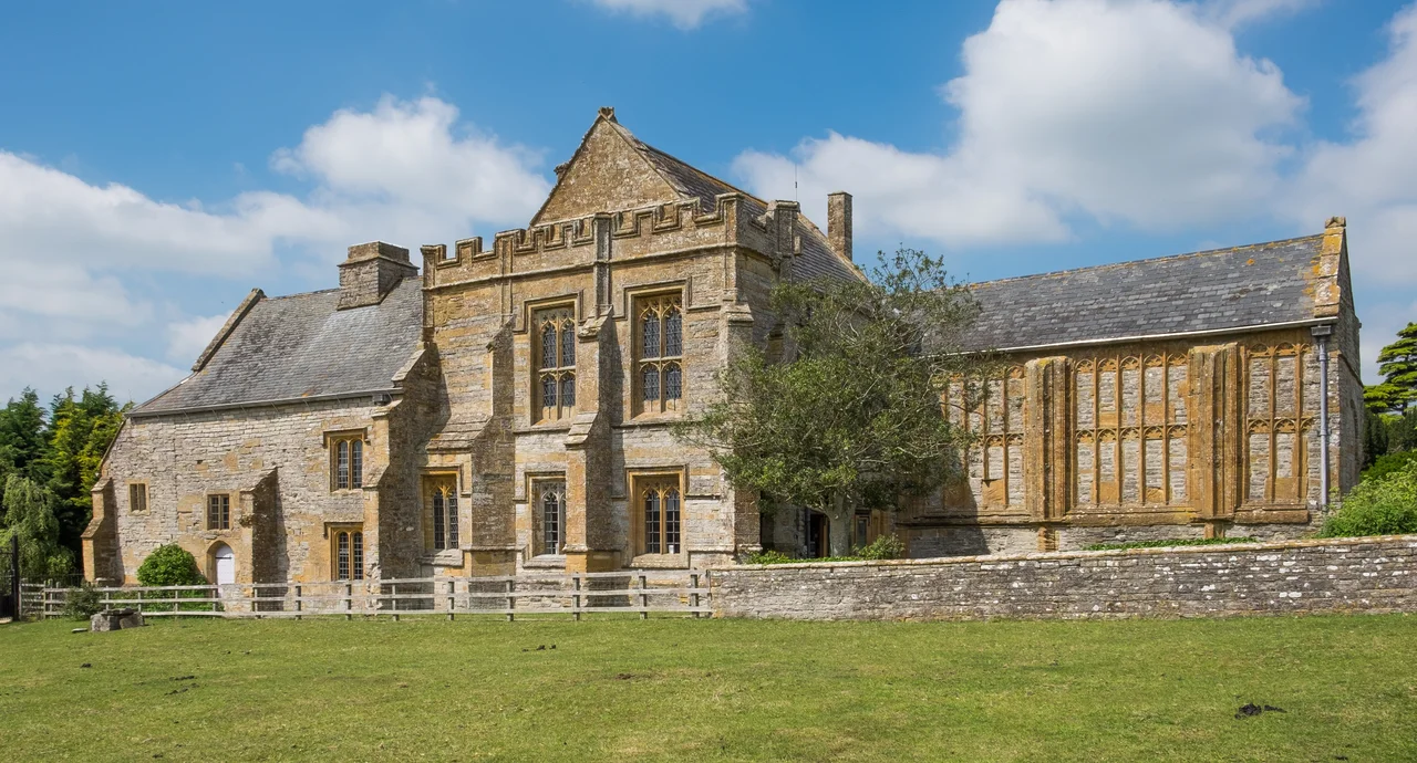

Muchelney Abbey
The name means 'big island' in Old English - mycel-eg, dry ground rising from marsh. In the 7th century the Levels around Muchelney were a sodden, half-flooded plain, and the abbey founded here in 693 stood quite literally on a small island, accessible by causeway only when the water dropped. By 1086 the monks paid their annual tax to William the Conqueror in eels: six thousand of them, caught in the local rivers and rhynes. Today the abbey is mostly outlines in the grass, but the Abbot's House still stands intact, and beside it a thatched two-storey lavatory that is unique in Britain.
An Island for Prayer
A religious building is believed to have stood on the site as early as 693, with a charter granted by Cynewulf of Wessex in 762. The Benedictines were not formally established until the 10th century. The refounders are not entirely clear - a document of 1535, drawn up for Thomas Cromwell's monastic accountants, named Centwine, Ine, Æthelstan and Æthelred as founders, though the charter of King Ine is now known to be a forgery. Tradition holds that Æthelstan's contribution was penance for the murder of Atheling Edwin in 933, or perhaps thanksgiving for victory at the Battle of Brunanburh in 937. What is certain is that Viking raids damaged the early buildings and that the rebuilt 10th-century abbey grew to become, by the high Middle Ages, the second-largest monastic foundation in Somerset, surpassed only by Glastonbury.
Six Thousand Eels a Year
The Domesday Book of 1086 records that Muchelney owned three islands in the Levels - Muchelney itself, Midelney, and Thorney - and that its annual tax was 6,000 eels caught from the surrounding rivers and marshes. Eels were currency, food, and tribute all at once, and the marsh that surrounded the abbey was simultaneously its inconvenience and its livelihood. The abbots accumulated land. They appropriated Perry Moor, drained sections of the Levels, and managed the embankments that contained the River Parrett. Around 1308 they built the Priest's House for the parish priest - it still stands, now owned by the National Trust. Between the 13th century and the dissolution, five Muchelney monks were sent to Canterbury College or Gloucester College at Oxford, sons of a small abbey punching above its weight in the medieval intellectual world.
Wyke and Broke
The abbey's last great building campaign came under two abbots whose names sound like a lawyers' partnership: William Wyke (1489-1504) and Thomas Broke (1505-1522). They rebuilt much of the complex, funded by leasing out the Demesne farm. The Abbey Church was 192 feet long and 52 feet wide. The Abbot's House - the only building to survive intact - dates from this period and shows what late-medieval monastic luxury actually looked like: a great chamber with an ornate fireplace, a carved settle, stained glass, a timber roof. Wall paintings still survive on the plaster, faded but legible, awaiting restoration. There are altogether about thirty monks here at the time, and they distributed £6 13s 4d a year in cash as alms to the poor - a generous sum for a small house.
The Surrender
In 1538 Henry VIII's commissioners arrived. The Dissolution of the Monasteries had been grinding through England for two years. The abbot and his small community surrendered the abbey and all its possessions to the king, signing the papers that ended eight centuries of prayer on the island. The buildings were demolished for their stone, which went into local farms, walls, and barns - which is why so many cottages around Muchelney have suspiciously well-cut blocks in their lower courses. Some of the decorative floor tiles from the monastic church were relaid in the neighbouring Church of St Peter and St Paul, where they survive. The property and the right to appoint the parish priest were granted to Edward Seymour, Earl of Hertford, later 1st Duke of Somerset and uncle to the boy king Edward VI. When Seymour was beheaded in 1552 the property reverted to the Crown. The Abbot's House passed through private hands. The Abbey Church became a quarry.
What Was Found in the Stones
In 1872 labourers gathering stone uncovered a blue coffin lid, and beneath it the pavement of the 14th-century lady chapel emerged, intact, the tiles still in their patterns where the medieval craftsmen had laid them. The discovery prompted growing local interest. In 1924 a community pageant involving around 500 people re-enacted the abbey's history from foundation to dissolution. Three years later, in 1927, the ruins were taken into public ownership by the Office of Works - the predecessor of English Heritage. The Abbot's House was designated a Grade I listed building in 1959. The ruins themselves are a scheduled monument.
The Lavatory That Survived
Of all the strange things to remain from a Benedictine abbey, the most unexpected is the monks' reredorter - the communal lavatory - which still stands two storeys high and thatched, the only one of its kind surviving in Britain. The reredorter sat above a flushing drain that emptied into the marsh, an engineering solution the Benedictines used in many of their houses but which has been preserved nowhere else. The barn west of the abbey is also a scheduled monument. Standing on the island today, you can walk the outlines of the great church in the grass, look up at the warm Ham stone of the Abbot's House, and sit in the same small lavatory where monks once sat at dawn and dusk, ringed by marsh and the call of waterfowl, on an island that was once - and to the eye still half is - just a slightly dry place in a great wet plain.
From the Air
Located at 51.02°N, 2.82°W on the Somerset Levels, two miles south of Langport. The abbey sits on a slight rise that becomes more obvious from the air during the winter flooding when surrounding fields fill with water. Recommended viewing altitude is 1,500-2,500 feet for clear sight of the abbey precinct, the parish church next door, and the medieval drainage pattern of rhynes that defines the surrounding land. Nearest airfields: Dunkeswell (EGTU) to the south, Bristol (EGGD) to the north, Exeter (EGTE) further southwest. The Polden Hills rise to the north, the Blackdown Hills to the south.
Nearby Stories
- Grand Pier, Weston-super-Mare 2.2 km away
- Royal Albert Memorial Museum 8.5 km away
- Royal Victoria Park 9 km away
- Siege of Lyme Regis 9.1 km away
- Dorset Museum 9.6 km away
- Stourhead 11 km away
- Porlock 17 km away
- Ewenny Priory 18 km away