.jpg)
New Exchequer Dam: The Wall That Buried a Town
On June 23, 1926, President Calvin Coolidge pressed a telegraph key from the White House, and turbines began spinning at a hydroelectric plant on the Merced River in central California. The old Exchequer Dam -- a 326-foot concrete arch -- had just entered service, creating a 14-mile lake and powering a 31-megawatt generating station. Forty years later, that dam would be swallowed whole. The New Exchequer Dam, completed in 1967, rose 490 feet above its foundations (479 feet above the river), encasing its predecessor as structural fill and flooding the town of Exchequer beneath a reservoir nearly four times larger. The town that gave the dam its name now exists only as a word on a map and a ghost visible in drought years, when falling water levels briefly expose the old arch like a fossil emerging from stone.
A Dam Inside a Dam
The engineering is remarkable for what it consumed. When farmers in the Merced River valley outgrew the old Exchequer Dam's 281,000 acre-foot capacity by the 1950s, the Merced Irrigation District proposed something audacious: rather than demolish the existing dam, they would build a much larger one just downstream and incorporate the old structure as an upstream toe, a buttress buried within the new embankment. New Exchequer is a concrete-faced, rock-fill dam -- its wall constructed in vertical zones of compacted, alternating layers of coarse and fine material, then armored with reinforced concrete on the upstream face. At the time of completion, it was the largest dam of its kind in the world. The reservoir it impounds, Lake McClure, holds more than one million acre-feet of water, enough to serve the irrigation district's sprawling farmland and generate hydroelectric power besides.
Leaks and Lessons
Pioneering engineering carries pioneering risks. New Exchequer was among the first high concrete-faced rock-fill dams ever built, and the untested design leaked -- sometimes dramatically, with seepage reaching 100 cubic feet per second. For nearly two decades the Merced Irrigation District managed the problem before the California Division of Safety of Dams ordered formal repairs in 1985. The leaks were sealed, but they had already taught the dam-building world a lesson: the concrete face of a rock-fill dam must be designed with far greater attention to joints and waterproofing than early engineers had assumed. New Exchequer became a case study, its problems informing the design of subsequent dams worldwide. The structure also proved its worth as a flood barrier, halting the devastating New Year's Day Flood of 1997 -- a storm system that overwhelmed rivers across California but met its match at Lake McClure.
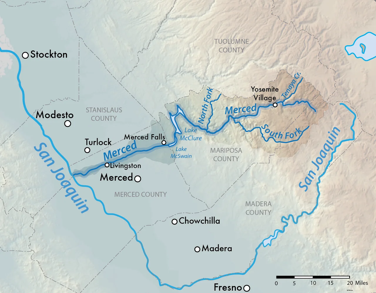
Feast and Famine
California's water story is one of extremes, and Lake McClure embodies both ends. The reservoir has never overflowed since the dam's completion, a fact opponents cite when the irrigation district proposes raising the spillway gates to add 70,000 acre-feet of storage. That proposal has drawn fierce resistance because it would partially flood a stretch of the Merced River designated Wild and Scenic -- one of the few remaining undammed sections of a river that flows from Yosemite's high country to the San Joaquin Valley floor. At the other extreme, three years of persistent drought drove the reservoir to its lowest recorded level in February 2015: just 63,489 acre-feet, less than seven percent of capacity. The exposed lakebed revealed contours of the landscape that existed before the dam -- a valley, a river channel, and perhaps a glimpse of the old Exchequer arch, still standing in the dark beneath all that missing water.
The Lake Above the Valley
Today Lake McClure serves double duty as infrastructure and recreation. Named for Wilbur F. McClure, California's State Engineer during the original dam's construction, the reservoir stretches through the Sierra Nevada foothills with 515 campsites, four boat ramps, and two marinas along its shores. Below the dam, an ogee-type gated spillway two miles to the north handles high-water releases, governed by flood-control rules tied to downstream flows at Stevinson. The dam stands 1,220 feet long and 1,000 feet wide at the base -- a mass of more than five million cubic yards of fill holding back a river born in Yosemite's glacial valleys. From the air, Lake McClure appears as a sinuous blue shape cut into golden-brown foothills, its arms reaching into side canyons, its surface reflecting the same Sierra light that once illuminated the town now resting beneath it.
From the Air
Located at 37.59°N, 120.27°W in the Sierra Nevada foothills of central California. From cruising altitude, New Exchequer Dam is visible as a massive embankment across the Merced River canyon, with Lake McClure extending eastward into branching side canyons. The reservoir's water level varies dramatically by season and drought cycle. The spillway is located approximately 2 miles north of the main dam. Merced Regional Airport (KMCE) lies about 20 miles west in the Central Valley. Castle Airport (KMER) in Atwater is roughly 25 miles northwest. The Merced River corridor downstream leads past McSwain Dam and toward the town of Snelling.
Nearby Stories
- The Curve Over the Canyon 5.8 km away
- Camp Mather 9.9 km away
- Twelve Thousand Bolts 10 km away
- Coarsegold, California 16 km away
- Merced National Wildlife Refuge 22 km away
- The Spinach Riot 35 km away
- The Man Who Auctioned a Sack of Flour Across America 59 km away
- Salinas and Steinbeck Country 91 km away