Nile
Herodotus, writing in the fifth century B.C., called Egypt 'the gift of the Nile.' Herodotus was right, but he was also thinking small. The Nile is the gift of eleven countries and five thousand years. It is the longest river in the world by most definitions - 6,695 kilometers from its headwaters in Burundi and Rwanda to its Mediterranean mouth at Rosetta, where the ancient Egyptian delta spills into the sea. Along the way it carries the story of Ancient Egypt, of Nubia, of Christian Ethiopia, of the Mahdist Sudan, of modern geopolitics over dams and water rights. Its basin spans eleven countries - Tanzania, Uganda, Rwanda, Burundi, the Democratic Republic of the Congo, Kenya, Ethiopia, Eritrea, South Sudan, the Republic of the Sudan, and Egypt - though the river's main course flows through Uganda, South Sudan, Sudan, and Egypt. To follow the Nile is to cross the Sahara's green edge, the savannas of East Africa, the high plateaus of Ethiopia, and the ruins of empires. Few rivers on earth have moved so many people so profoundly.
Two Rivers, One Name
The Nile is really two rivers that meet. The White Nile rises in the Great Lakes region of central Africa - Lake Victoria, fed by rains on the equatorial highlands of Tanzania, Uganda, Rwanda, and Burundi - and meanders north through enormous swamps in South Sudan before reaching Khartoum in Sudan. The Blue Nile rises at Lake Tana in the Ethiopian highlands, plunges down the Blue Nile Gorge, and arrives in Khartoum carrying 80 percent of the combined river's volume during the summer flood. At Khartoum the two rivers join, the White Nile broad and silty with African soil, the Blue Nile dark and fast with Ethiopian highland runoff. You can stand at their confluence and watch the two currents run side by side for hundreds of meters before the turbulence mixes them. The location is strategic and often restricted to photography - the confluence has been fortified for centuries.
Ancient Egypt and Its Neighbor
Most of the Nile flows through arid country. In the Egyptian and northern Sudanese Sahara, the river provides essentially all the water available for farming - a thin green ribbon in an ocean of sand. That geography is why Ancient Egypt emerged where it did. Pharaohs from roughly 3100 B.C. ruled a civilization whose agriculture, religion, and political power all depended on the river's annual flood. Upstream, contemporary with the pharaohs, the kingdom of Nubia grew up in what is now northern Sudan - its people trading gold and ivory, building pyramids at Meroe and Nuri that are less famous than Giza but equally remarkable. The relationship between Egypt and Nubia was complex: sometimes trading partners, sometimes mutual conquerors, always linked by the river that connected them. For 2,000 years after the Roman conquest of 30 B.C., the Nile Valley was ruled by foreign empires - Romans, Byzantines, Arabs, Ottomans, and finally the British. Since 1956, Egypt has been independent, and today is the most populous Arab country in the world.
Cities Along the River
From south to north, the Nile threads together an extraordinary sequence of cities. Khartoum, the Sudanese capital, sits at the Blue Nile and White Nile confluence - a city as of 2023 tragically convulsed by civil war, with military conflict continuing, ceasefires declared and broken, and travel there actively dangerous. Upriver into Egypt, Aswan sits above the Aswan High Dam (completed in 1970) and marks the traditional boundary between Egypt and Nubia. The stretch from Aswan downriver to Luxor is dense with temples and tombs - Kom Ombo, Edfu, Esna, the great Karnak and Luxor temples, the Valley of the Kings where Tutankhamun's tomb was discovered in 1922. Luxor to Cairo passes through the heartland of ancient Upper and Middle Egypt. Cairo - the largest city along the entire river - sits near the apex of the Nile delta and the Pyramids of Giza. Downstream of Cairo, the river splits into the delta's branches, and Alexandria occupies the western edge, where the Nile once had a mouth and no longer does.
A Classic Way to See It
For travelers, the classic Nile experience is the felucca cruise - sailing down the Egyptian portion of the river on a traditional lateen-rigged boat, the kind that Nile boatmen have been using for more than a thousand years. Modern cruise ships ply the Aswan-to-Luxor stretch in greater numbers, but the felucca is what makes you understand how the river works. You sail at the speed of wind and current. You stop where the boat needs to stop. At night, you tie up to a sandbank and eat dinner cooked on a small stove, under a sky the desert keeps clear of clouds. The full overland itinerary from Alexandria to Cape Town by train and bus - one of the classic African journeys - closely follows the Nile on its northern section before turning inland. For the traveler willing to plan around current political realities, no single journey on earth traces so long a thread of human history as following the Nile from its sources to its sea.
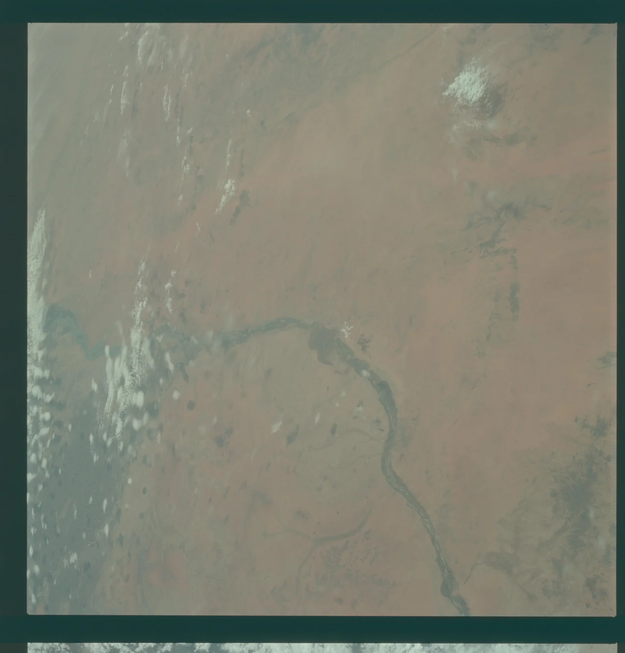
From the Air
The Nile flows 6,695 km from its most remote headwater source (sometimes traced to Burundi/Rwanda) to its mouth at Rosetta on the Mediterranean. Reference point for this entry is Khartoum's confluence at 15.64 degrees north, 32.51 degrees east. Major airports along the river include Khartoum International (HSSS), Aswan International (HESN), Luxor International (HELX), and Cairo International (HECA). From cruising altitude over Egypt, the Nile is unmistakable: a narrow green ribbon cutting through utterly barren desert on both sides. The contrast between cultivated floodplain and Sahara is one of the most visible human geography features on Earth from above.
Nearby Stories
- Esh Shaheinab 27 km away
- Naqa 56 km away
- Mahdist War 65 km away
- Musawwarat es-Sufra 100 km away
- Gezira State 101 km away
- Northern Sudan 215 km away