.jpg)
Nuggety Gully Water Race and Chinese Camp
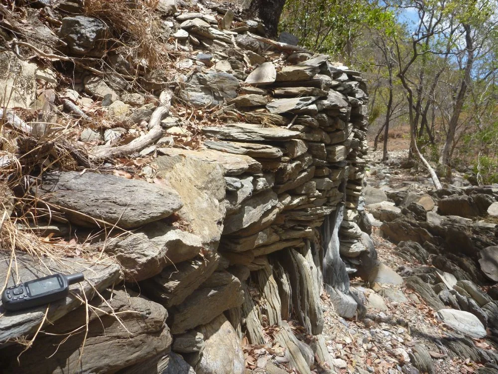
The walls are what remain. Threaded along the bed of a dry, rocky ravine southwest of Cooktown, hundreds of metres of carefully fitted stone climb the sides of Nuggety Gully - retaining walls, some stacked in two or three tiers, holding back the broken country as they have for well over a century. No mortar binds them; they hold by the skill of their placing alone. They were built in the 1880s by Chinese miners working the Star of Normanby diggings, and today they are recognised as the finest and most extensive surviving example of Chinese stonework in Queensland.
Gold in the West Normanby
Gold was first reported officially in the West Normanby River country, southwest of Cooktown, in November 1874 - a corner of the sprawling Palmer River goldfield that had set off one of the great rushes of the colonial era. The diggers came fast. By the end of January 1875 more than 600 men were working the field, many of them drifting across from the camp at Maytown. At first the mining warden barred Chinese miners from the diggings altogether. But the bar did not hold, and it was never going to: across the Palmer as a whole, Chinese miners would soon outnumber Europeans many times over. By February 1878 at least 200 Chinese were working the alluvial ground at the Normanby, panning the gravels for the gold that others had missed or abandoned.
The Men Who Built the Walls
These were not transient fortune-hunters so much as a working community, most of them from the villages of Guangdong in southern China. They had crossed an ocean and walked inland from the coast to reach this ground, and they worked it with a patience and method that even hostile observers conceded was effective. When a mining warden visited in May 1886, he counted thirty to forty Chinese men at the Normanby - some working the alluvials, others tending three vegetable gardens given over chiefly to maize, which sold readily to the miners at the reefs. The stone walls of Nuggety Gully are the physical record of that labour: terraces to work the creek, foundations for dwellings, and nine small earth platforms by the water that mark where the camp itself stood, two of them still holding the stones of fireplaces and ovens. It was, in every sense, a place where people lived.
Lives Lived Under Suspicion
The skill of the stonework should not soften the conditions that surrounded it. The Chinese on the Palmer arrived into open hostility, and the colony wrote that hostility into law. They were confined to ordinary claims even when they qualified for larger ones, discouraged from the more profitable reef mining, and in 1877 made to pay a punishing entry tax aimed squarely at them. They endured all of it and kept working. A nomination once described the larger stone structure at the camp as a fort from which Chinese miners supposedly hid and fired on Aboriginal people - a claim heritage experts have flatly rejected. It was an oven, not a fort. The error is worth naming, because it turned a domestic hearth - the most ordinary symbol of home - into an emblem of imagined menace, and in doing so distorted the lives of two peoples at once. What the stones actually testify to is far quieter: people cooking, sheltering, and getting on with the work of survival in a hard and unwelcoming place.
Why the Stones Survived
Most goldfield camps were ground back to nothing - reworked by later miners, scavenged for materials, erased by time. Nuggety Gully endured for an unglamorous reason: the country is so broken and the access so difficult that no one ever found it worth the trouble to mine the site again. That same isolation that once made the miners' lives harder ultimately protected what they built. The walls were added to the Queensland Heritage Register in 1992, valued as a rare and intact testament to the Chinese contribution to the colony's history - a contribution long pushed to the margins of the story. Stand in the gully now and the silence is almost total. But the stones are still squarely set, still doing their work, still speaking for the men who placed them.
From the Air
Nuggety Gully lies at approximately 15.98 degrees S, 144.93 degrees E, in remote ranges of the Mareeba Mining District near Lakeland, southwest of Cooktown in Far North Queensland. There is no settlement here - the site is a steep, dry, stone-walled ravine draining into Prospect Creek, set in rugged, sparsely vegetated goldfield country with very difficult ground access. The nearest airports are Cooktown (ICAO YCKN) to the northeast and Cairns (YBCS) further south; Lakeland is the nearest road locality. The terrain is broken and remote with few landmarks; the dry winter months offer the clearest conditions, while the summer wet brings heat, haze and afternoon storms. Carry adequate margins over this isolated country.
Nearby Stories
- Quinkan Rock Art 13 km away
- Endeavour Reef 15 km away
- Low Isles Light 24 km away
- Daintree National Park 24 km away
- Cooktown Cemetery 30 km away
- Old Laura Homestead 34 km away
- OK Mine & Smelter 55 km away
- Cod Hole 110 km away