Nusa Lembongan: Where the Seaweed Farmers Became Surf Guides
The surf break called Lacerations earned its name honestly. The shallow reef beneath it has opened skin on enough surfers to make the point, and yet they keep paddling out. That is the paradox of Nusa Lembongan -- an island small enough to walk across in an hour, remote enough that cars are nearly useless, and magnetic enough that surfers, divers, and backpackers have been finding their way here for decades. Eight square kilometers of coral-rimmed limestone rising from the Badung Strait, twelve kilometers southeast of Bali, Nusa Lembongan sits at the busy intersection of two oceans and two biological worlds. The Wallace Line runs through the strait to its east, marking the boundary where Asian fauna gives way to Australasian species -- a biogeographical frontier that Alfred Russel Wallace mapped in the nineteenth century and that the currents here still enforce.
Shipwrecks, Lacerations, and Playgrounds
Three reef breaks made Nusa Lembongan famous, and their names read like a warning label. Shipwrecks, on the island's northwest side, draws its name from the rusting hulks visible at low tide. Lacerations, further south, breaks over a reef so shallow that wipeouts come with consequences. Playgrounds, the most forgiving of the three, offers a faster, more playful wave that works across a wider range of tides and skill levels. Together they create a surfing triangle that has appeared on surf magazine covers and contest circuits for years. But the waves are only half the draw. Below the surface, the coral reefs that shape those breaks also support some of the richest marine life in the Indonesian archipelago. Divers come for manta rays, oceanic sunfish -- the enormous, flat-bodied mola mola that drift through the strait's deep channels -- and walls of coral that drop into blue water. Snorkelers find their own world in the shallows, where reef fish scatter between staghorn formations just meters from shore.
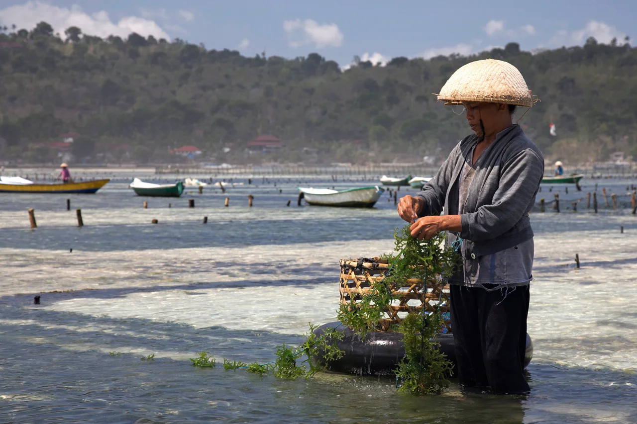
The Seaweed Cycle
Before the surfers arrived, Nusa Lembongan's economy floated on seaweed. Families farmed it in the shallows along the island's eastern shore, staking lines of Eucheuma and Gracilaria to wooden frames in the warm, nutrient-rich water. The dried product was exported for use in food processing and cosmetics -- carrageenan, the thickening agent in everything from ice cream to toothpaste. For years, the seaweed frames and the tourism infrastructure existed side by side, an improbable coexistence of agriculture and leisure. Then tourism won. By 2015, pollution and boat traffic from the growing number of speedboat services had degraded water quality enough to make seaweed farming unviable. The frames disappeared. But the story did not end there. When the COVID-19 pandemic shut down international travel in 2020, the tourists vanished overnight. With no visitors and cleaner water, seaweed farming quietly returned. Families who had traded harvest lines for guesthouse management went back to the shallows. The cycle revealed a truth about island economies: they are only ever one disruption away from reinvention.
Two Islands, One Bridge
A narrow suspension bridge connects Nusa Lembongan to its smaller neighbor, Nusa Ceningan, spanning a tidal channel so shallow that at low tide you could nearly walk across the exposed sand. The original bridge -- a swaying, yellow-painted structure wide enough for a single motorbike -- became one of the most photographed landmarks in the Nusa Islands. In October 2016, it collapsed, killing several people and injuring others. The rebuilt bridge is sturdier but still restricted to foot and motorbike traffic; cars cannot cross. Below the bridge, the estuarine channel shifts with the tides, creating currents that local fishermen read the way commuters read traffic patterns. Nusa Ceningan itself remains far quieter than its neighbor, a place of cliff edges, blue lagoons, and seaweed farms that never entirely disappeared. The two islands share an administrative village -- Lembongan Village governs both -- but their characters diverge. Lembongan looks outward to the tourist boats arriving from Sanur. Ceningan looks inward, content with its cliffs and its quiet.
Mangroves and Mola Mola
The northeastern corner of Nusa Lembongan is claimed not by tourists or farmers but by mangroves -- some 212 hectares of them, a surprisingly large forest for so small an island. These tangled root systems serve as nurseries for juvenile fish and crustaceans, buffer the coastline against storm surge, and trap sediment that would otherwise smother the surrounding coral reefs. Kayak tours thread through the mangrove channels at high tide, passing beneath canopies alive with herons and kingfishers. Conservation has become central to the island's identity, not just as an ecological imperative but as an economic one. Marine conservation organizations have partnered with local communities to establish reef restoration projects, and on the southwestern coast at Sunset Beach, volunteers participate in a release program for olive ridley turtles -- a vulnerable species whose hatchlings are raised in protected enclosures before being released into the Badung Strait. The logic is straightforward: the reefs and the marine life they support are the reason tourists come, and without them, the guesthouses and surf shops have no purpose.
From the Air
Nusa Lembongan sits at 8.68S, 115.45E, twelve kilometers southeast of Bali across the Badung Strait. From altitude, the island appears as a small, roughly triangular landmass with visible white sand beaches on its western shore and a dark mangrove area on its northeastern side. The narrow channel and bridge connecting it to Nusa Ceningan to the south are visible at lower altitudes. Nearest major airport is Ngurah Rai International Airport (WADD/DPS) in southern Bali, approximately 30 km northwest. The larger island of Nusa Penida is visible directly to the south-southeast. The Wallace Line runs through the Lombok Strait to the east. Tropical marine climate with clearest visibility during the dry season (April-October).
Nearby Stories
- The Mother Temple: Bali's Stairway on the Volcano 8.1 km away
- The Words Written on Leaves 17 km away
- The Day Seririt Fell Silent 31 km away
- Lake Segara Anak 43 km away
- Alas Purwo: Where Java Begins and the Surf Never Stops 54 km away
- The Silent Wave: Java's 1994 Tsunami Earthquake 287 km away
- When the Towers Fell: The Waru Wora Fire 374 km away
- Sumba's Hidden Kingdom of Wings 468 km away