Building a Capital From Scratch in the Borneo Rainforest
Jakarta is sinking. Not metaphorically -- the city is physically descending into the Java Sea. Decades of uncontrolled groundwater extraction have caused parts of North Jakarta to drop more than 2.5 meters in the past decade, and at the current rate, a third of Indonesia's capital could be submerged by 2050. So the Indonesian government decided to do something that sounds almost absurd in its ambition: build an entirely new capital from scratch, 1,240 kilometers away, in the rainforests of Borneo. They named it Nusantara, an old Javanese word meaning "archipelago" -- a name that invokes not just geography but the idea of a nation spread across 17,000 islands, finally governed from its geographic center rather than its overcrowded western edge.
Why Abandon a City of 11 Million?
Jakarta's problems run deep, and they compound each other. The city sits on swampy, low-lying ground at the mouth of thirteen rivers. Massive population growth -- from 1.5 million in 1950 to over 11 million today, with a metro area of 34 million -- has overwhelmed its infrastructure. Groundwater pumping has caused the land to subside, even as climate change raises the Java Sea. Flooding paralyzes the city regularly. Traffic congestion costs the economy billions annually. Air quality ranks among the worst in Southeast Asia. Indonesia has talked about moving its capital since the 1950s, under presidents Sukarno and Suharto, but it was Joko Widodo who finally committed in August 2019, selecting a site in East Kalimantan on the island of Borneo. The location was chosen partly for its central position in the Indonesian archipelago, partly for its relatively low risk of earthquakes, floods, and volcanic eruptions, and partly because much of the land was already government-owned.
A Forest City on Paper
The winning design concept, "Nagara Rimba Nusa" -- roughly "Forest Archipelago" -- envisions a city where 65 percent of the 2,560-square-kilometer site remains green space. On paper, Nusantara will be walkable and transit-oriented, with 80 percent of trips made by public transport. Plans call for two metro lines, a bus rapid transit system, autonomous minibuses, and a citywide network of cycling paths. A new toll road will connect the government core to Balikpapan, 47 kilometers to the south. Three airports will serve the capital: Balikpapan's Sultan Aji Muhammad Sulaiman Sepinggan International, Samarinda's Aji Pangeran Tumenggung Pranoto International, and a new Nusantara International Airport to be built in Penajam. The vision is deliberate and striking -- a counterpoint to Jakarta's organic, gridlocked sprawl. Whether the reality will match is another question entirely.
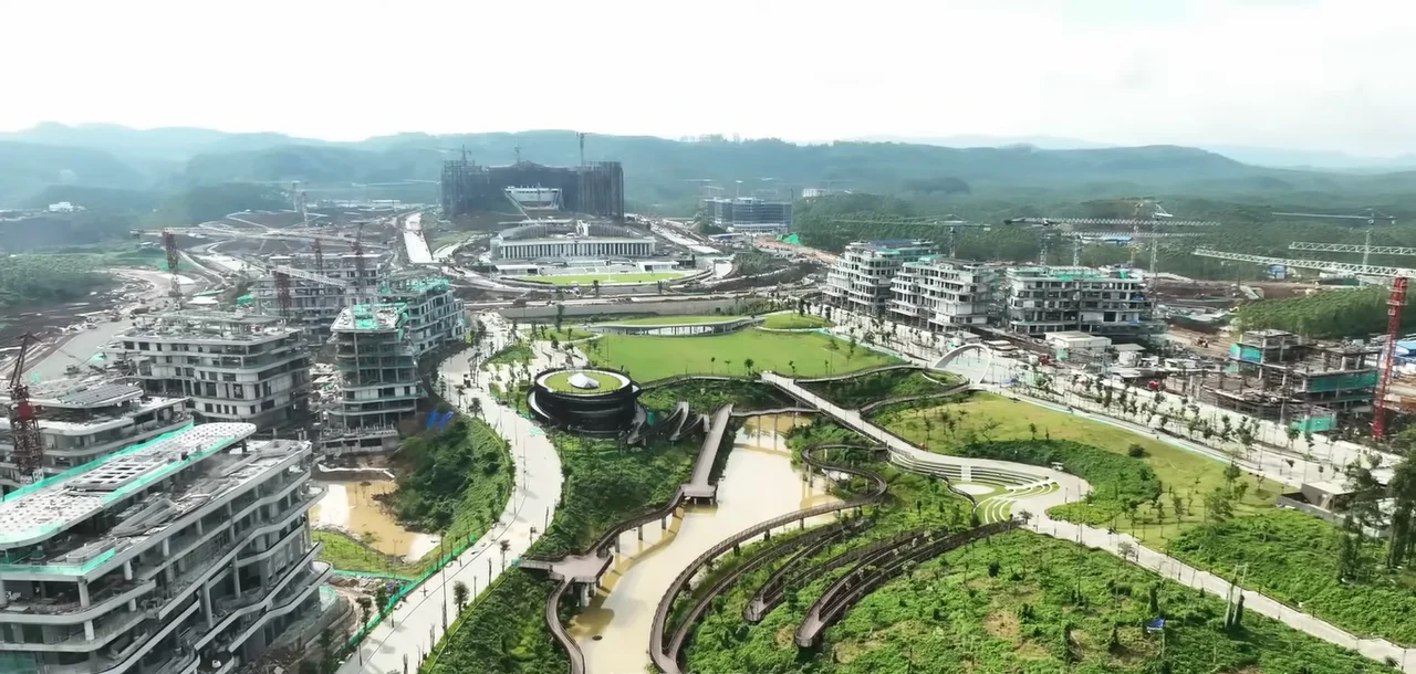
The Clearing in the Trees
Construction began in earnest in 2022, and satellite images show the transformation. Where dense tropical forest once stood, roads now radiate outward from a central government precinct. The Presidential Palace was completed and inaugurated in August 2024, a swooping modern structure meant to evoke the wings of Garuda, the national emblem. The Vice Presidential Palace followed in January 2026. But the ambitions have been scaled back. Under President Prabowo Subianto, who took office in October 2024, Nusantara was reclassified from full replacement capital to "political capital," with Jakarta retaining its economic primacy. State funding dropped sharply -- from roughly $2.7 billion in 2024 to approximately $380 million allocated for 2026. Private investment has partially filled the gap, exceeding $4 billion, but the pace of construction has slowed. As of late 2025, the city's population stood at 147,000, almost entirely in existing villages like Bumi Harapan and the district of Sepaku.
What Gets Lost in the Jungle
Environmentalists have not been quiet. The site occupies land in the regencies of Kutai Kartanegara and Penajam North Paser, regions that are home to orangutans, sun bears, proboscis monkeys, and Borneo's spectacular biodiversity. Much of the terrain is peat bog and swampland, ecosystems that store enormous quantities of carbon. Clearing and developing this land releases that carbon and destroys habitat that cannot be rebuilt. Indigenous Balik and Paser communities, who have lived on this land for generations, face displacement. The government's promise that 65 percent of the site will be green space offers some reassurance, but converting primary rainforest to managed parkland is not a neutral exchange. The rain that falls here -- over 3,200 millimeters a year -- once filtered through an ancient forest canopy. Now it runs off construction sites into Balikpapan Bay.
A Capital Between Two Futures
Nusantara is governed not by an elected mayor but by an appointed Authority Head at cabinet level, currently Basuki Hadimuljono. Four thousand civil servants are scheduled to relocate in 2026, with legislative and judicial buildings breaking ground in late 2025 and targeting completion by 2027. The city is twinned with Astana, Kazakhstan -- another purpose-built capital, transplanted from Almaty in 1997. The parallel is instructive. Astana took decades to become a functioning city, and its early years were marked by grandiose buildings standing half-empty on the steppe. Nusantara may follow a similar trajectory: impressive structures rising in clearings that still smell of freshly cut timber, waiting for the human density that gives a city life. Whether Nusantara becomes a visionary forest metropolis or an expensive monument to political ambition will depend on decisions still being made. For now, it remains one of the most audacious urban experiments on Earth -- a capital city being willed into existence in the middle of one of the planet's last great rainforests.
From the Air
Nusantara is located at approximately 0.97S, 116.71E on the east coast of Borneo in East Kalimantan, Indonesia. The site spans parts of Kutai Kartanegara and Penajam North Paser regencies. Nearest major airport is Sultan Aji Muhammad Sulaiman Sepinggan International Airport (WALL) at Balikpapan, approximately 47km south. Aji Pangeran Tumenggung Pranoto International Airport (WALS) at Samarinda serves the region from the north. From cruising altitude, the construction zone is visible as cleared areas within dense tropical forest, with roads radiating from a central government precinct. Balikpapan Bay is visible to the south.
Nearby Stories
- Ninety-Nine Names in the Sky Over Samarinda 23 km away
- Fire on the Water at Balikpapan 31 km away
- The Mahakam: Borneo's River of Kingdoms and Dolphins 48 km away
- The Bridge That Tried to Be Golden 59 km away
- Sixty Seconds Over Banjarmasin 152 km away
- Oil, Empire, and the Fight for Borneo 237 km away
- The Million-Hectare Mistake 252 km away
- The Ground Beneath Mamuju 285 km away