
Orford Ness
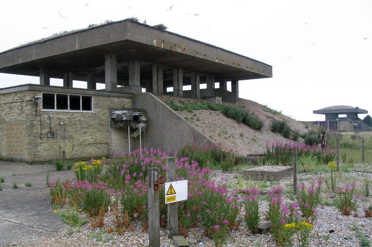
The pagodas are still there, low concrete buildings with heavy roofs designed to flex upward and vent the blast if something inside went wrong. Inside them, in the 1950s and 1960s, the Atomic Weapons Research Establishment shook, dropped, and pre-detonated the trigger mechanisms of British nuclear bombs to see whether the high explosive lenses would behave correctly under stress. Today the National Trust runs careful tours past these buildings, and a sign warns visitors to stay on the marked paths because not everything left behind on Orford Ness has been catalogued.
A Spit Made of Other Places
Orford Ness is a ten-mile shingle spit hooked along the Suffolk coast between Aldeburgh and Shingle Street, divided from the mainland by the River Alde and built almost entirely of flint pushed south by longshore drift. The material started life further north, eroded out of the cliffs of Dunwich and Covehithe, and the storm waves keep pitching it across the beach crest into stable ridges and coarser swails. It is Europe's largest vegetated shingle spit and covers about 2,230 acres, of which 890 are bare shingle, 556 are tidal river and mud and lagoon, 400 are grassland, and 330 are salt marsh. The habitat is internationally scarce, fantastically fragile, and one footstep too many can crush plants that took a century to colonise. Before about 1200 the spit was much shorter and Orford was an open-sea port. The shingle has been quietly closing the harbour ever since.
Where Radar Was Born
In February 1935, Robert Watson-Watt proved that radio waves could detect aircraft at a field in Northamptonshire, using a BBC transmitter at Daventry as the signal source. The Air Ministry was convinced. Watson-Watt's team moved to Orford Ness in May 1935 with portable receivers and began systematic trials; by the end of the year they could track targets at one hundred kilometres. Watson-Watt and his team then moved to nearby Bawdsey Manor and turned the work into Chain Home, the radar network that gave Fighter Command the precious extra minutes that mattered in the Battle of Britain. Orford Ness was also the site of the Orfordness Beacon set up in 1929, one of the first long-range radio navigation experiments. The peninsula was already the place where signal theory met the open sky before the war made the work essential.
The Pagodas and the Cold War
After the war the Atomic Weapons Research Establishment took over. The pagodas were built in the late 1950s and early 1960s for environmental testing, a polite phrase that meant putting the conventional explosive components of a nuclear weapon through extremes of vibration, temperature, and pre-detonation to confirm they would still work as designed. The roofs were engineered to lift off if a test went catastrophically wrong, venting the blast upward instead of sideways toward the rest of the site. No fissile material was used on the Ness, but the work was secret enough that the pagodas became the dominant feature of the southern peninsula. In the late 1960s an Anglo-American over-the-horizon radar called Cobra Mist was added in the north, designed to track Soviet aircraft and missiles by bouncing signals off the ionosphere. It closed in 1973 after persistent unexplained interference, and the building was later reused as the Orfordness transmitting station, broadcasting the BBC World Service in English to continental Europe on 648 kHz from 1982 until 2011.
Strange Stories and Strange Light
Closed to the public for most of the twentieth century, Orford Ness became a magnet for stories. A persistent legend held that German troops had attempted to land near Shingle Street during the war and been repelled with a wall of fire, an account official sources denied and that classified documents released in 1993 confirmed never happened. In December 1980, the flashes from Orfordness Lighthouse were implicated in the Rendlesham Forest UFO sightings just inland. The lighthouse itself was decommissioned in 2013 and demolished in summer 2020, the encroaching sea finally catching up. The National Trust now opens the site by ferry from Orford Quay on designated days, the Bomb Ballistics Building and the Black Beacon converted into viewing spots. The writer Rachel Woodward calls it a place of strange contrasts, a hostile and potentially dangerous site whose elemental nature has to be balanced against its inherent dangers. What is being conserved here is not celebratory. It is the physical record of what the twentieth century thought it had to do.
From the Air
Orford Ness lies at 52.081 N, 1.559 E, stretching about ten miles southwest from Aldeburgh past Orford to North Weir Point. Best viewed from 2,000-4,000 feet, where the shingle ridges and lagoons of the spit show as parallel curves against the brown of the marshes. Look for the distinctive concrete pagodas in the southern half and the long lattice masts of the former transmitting station. Nearby airfields: Wattisham (EGUW) 25 miles west, Norwich (EGSH) 35 miles north. The Ness is a restricted overflight area in places; check current notices.
Nearby Stories
- Beccles 7.6 km away
- The Food Museum 8.6 km away
- Old Buckenham Airfield 13 km away
- White House Farm murders 20 km away
- Walton-on-the-Naze 22 km away
- Four Days' Battle 22 km away
- Southern Bight 51 km away
- Battle of Lowestoft 56 km away