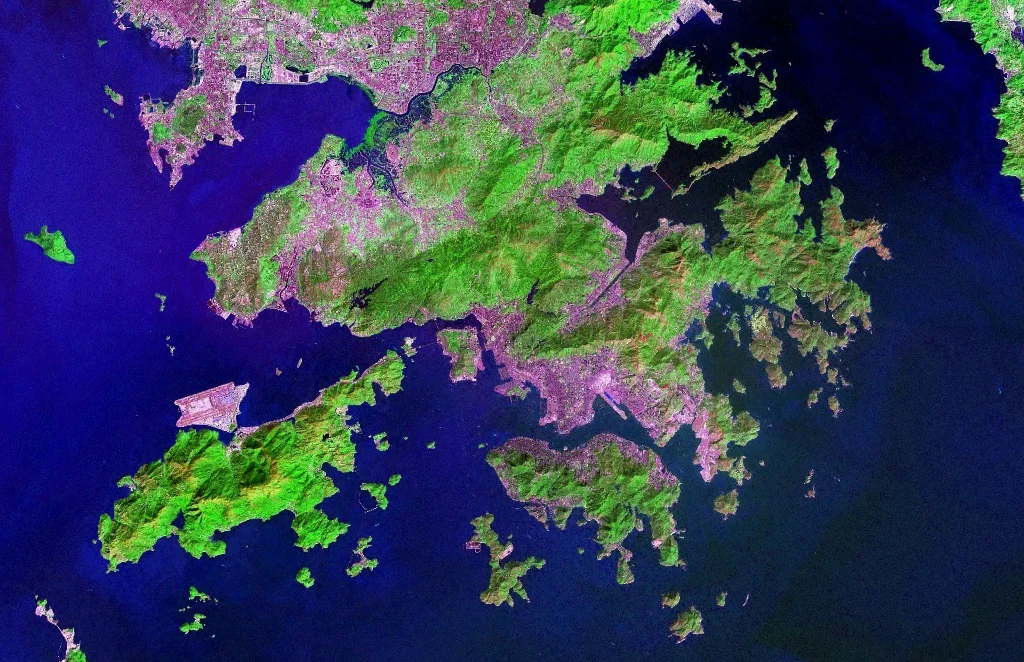

Outlying Islands, Hong Kong
Take the ferry from Central and within twenty minutes the towers of Hong Kong begin to recede. By the time you reach Cheung Chau or Peng Chau, you are in a different Hong Kong entirely — one of fishing villages, hiking trails, incense-thick temples, and coastlines where the South China Sea is still audible over the wind. There are 263 islands in Hong Kong over 500 square meters. Most people in the city have never visited most of them.
The Shape of the Territory
The 'outlying islands' is not a precisely defined category. Officially, it refers to all of Hong Kong's islands except Hong Kong Island itself and a handful of smaller islands close to its coast. The largest and most significant is Lantau, which at over 140 square kilometers is actually bigger than Hong Kong Island. Beyond Lantau, the islands range from substantial — Lamma, Cheung Chau, Peng Chau — to barely inhabited rock outcroppings visible from the ferry rail.
Geographically, the islands divide roughly by direction. Islands District in the south and southwest holds the most visited ones. Sai Kung District's islands to the southeast are wilder and more remote. Tai Po and North District in the northeast hold a scattering of smaller islands close to the mainland Chinese border, some of them accessible only by the small motorized boats called kai-to.
Late Development, Lasting Character
For most of Hong Kong's colonial history, inconvenient transport kept the outlying islands separate from the territory's rapid urbanization. Ferries ran on schedules that suited fishermen and farmers, not commuters. The result was that traditional village life persisted on Lamma, Cheung Chau, and Peng Chau long after it had been demolished in the city. Some of that character survives today, though altered by tourism and by the residents — many of them expatriates and artists — drawn to lower rents and a different pace.
Lantau is the exception. Its transformation began in earnest in the 1980s, when Discovery Bay was privately developed as an upmarket residential enclave with ferry service to Central's business district. Then came the defining change of the 1990s: the construction of Hong Kong International Airport on reclaimed land off Lantau's northern coast, bringing a road-rail bridge connecting the island to urban Kowloon, and turning the small settlement of Tung Chung into a new town adjacent to the terminals.
Where Tsing Yi Became the City
Not all outlying islands stayed outlying. Tsing Yi, in the late 1970s, was absorbed into Tsuen Wan New Town, connected to the mainland by road and rail bridges and developed into a dense residential and industrial district. From the air, the seams are visible — Tsing Yi's flat container terminals and petrochemical tanks against its older residential blocks, the bridge approaches cutting across what was once open water.
Hong Kong Disneyland Resort, which opened in 2005 on the northeastern shore of Lantau, brought another layer of transformation — and with it a light rail connection and planned road links that continue to extend the urban footprint into what had been rural land. The outlying islands are not static; they are a frontier that the city keeps advancing across, island by island.
The Rural Remainder
Away from Lantau's northern development corridor and Tsing Yi's industrial piers, much of the island territory remains genuinely rural. Lamma's Power Station Road, lined with seafood restaurants overlooking an absurdly photogenic harbor, is a kind of HK institution. Cheung Chau's narrow lanes — no private cars are permitted on the island — fill with weekenders every Saturday and Sunday, escaping the city for something that feels, briefly, like another era. Hikers cross Peng Chau and South Lantau in relative quiet.
These islands work as pressure-release valves for one of the most densely populated territories on earth. The South China Sea coastlines, the incense-filled tin-roofed temples, the seafood brought up in the morning — none of it is untouched or frozen in time, but neither has it been entirely consumed by the city that presses in from every direction.
The Ferry as Lifeline
The ferry network is the circulatory system of the outlying islands. From Central's ferry piers, regular services connect to Peng Chau, Cheung Chau, Lamma, and Lantau's Mui Wo. Discovery Bay runs its own private high-speed service. From Aberdeen harbor on Hong Kong Island's south side, ferries reach Lamma and the remote Po Toi Island group. Small kai-to boats fill in the gaps — Sam Ka Tsuen to Tung Lung Island, Ma Liu Shui and Wong Shek to the Grass Islands, Sha Tau Kok pier to Kat O near the mainland border.
For an island territory that prides itself on connectivity, the ferries are a reminder that not everything has been bridged or tunneled. Some of these crossings are still just a boat, some water, and the outline of an island getting larger as you approach.
From the Air
The outlying islands of Hong Kong center roughly on 22.2211°N, 114.0099°E, southwest of Hong Kong Island. From the air, the scale of the island territory becomes clear: Lantau dominates the western approach, its peaks rising to over 900 meters at Lantau Peak; the smaller islands of Cheung Chau, Peng Chau, and Lamma lie scattered to the south and southeast. Hong Kong International Airport (VHHH) occupies reclaimed land off Lantau's northern coast. Approach and departure corridors for VHHH cross the northern outlying islands, making this one of the most visually dramatic approaches to any major airport. Suggested viewing altitude: 3,000–5,000 ft on the western approach, with Lantau's ridgeline to the south and the Pearl River estuary opening to the west.
Nearby Stories
- Lok Ma Chau Loop 2.3 km away
- Portas do Cerco 2.3 km away
- Kweilin Incident 17 km away
- Wanshan Archipelago Campaign 34 km away
- Nanxiong Formation 115 km away
- Battle of Nanpeng Island 148 km away
- Heyuan 169 km away
- Cape Maobitou 632 km away