Oyapock
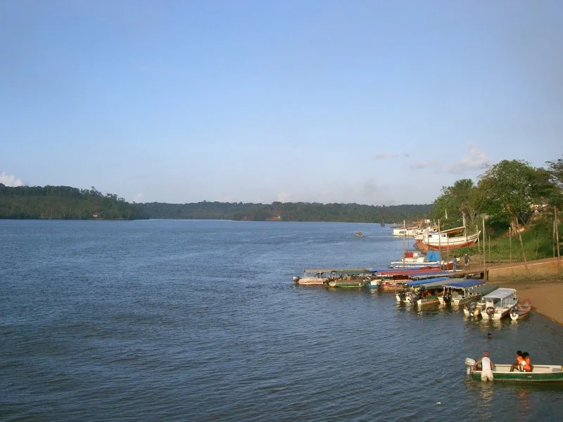
A river can be many things at once: a road, a larder, a border. The Oyapock is all three. It runs 403 kilometers from the Tumuk Humak mountains down to the Atlantic, and for most of that length it marks the boundary between the French department of French Guiana and the Brazilian state of Amapá. For centuries it carried the boats of Wayana and Palikur Indigenous peoples, then the expeditions of Englishmen and Dutchmen, then the survey lines of four competing empires. Its name has been spelled Japoc, Yapoc, Iapoco, Wiapoco, even called the Vicente Pinzón River after the Spanish explorer who sailed past in 1500. The current official spelling - Oiapoque in Portuguese, Oyapock in French - was settled only in 1900, when Swiss diplomats ended a lingering territorial dispute.
From Mountain to Sea
The Oyapock rises in the Tumuk Humak mountain range - a remote highland that also gives birth to tributaries of the Amazon itself - and runs north through Guianan moist forest until it reaches the Atlantic. At its mouth, the river's estuary forms a broad bay bordered on its southern side by Cape Orange. Cape Orange is the northernmost point of Brazil's coastline. This causes persistent confusion. Because the border between Brazil and French Guiana meets the ocean at the Oyapock, and because Cape Orange is the country's northernmost coastal point, many Brazilians grow up believing the cape or the river mouth is the northernmost point of all of Brazil. It isn't. The true northernmost point is Monte Caburaí in Roraima state, hundreds of kilometers inland and almost a full degree of latitude farther north. The confusion reached formal textbooks for decades before being quietly corrected.
Wiapoco, 1608
Europeans arrived at the Oyapock long before any of the current spellings of its name existed. The Englishman Robert Harcourt led an expedition that established a short-lived settlement on the Wiapoco - as he called it - in 1608, just one year after Jamestown. Harcourt's expedition failed: the colony couldn't sustain itself against tropical disease, uncertain supplies, and hostility from groups that were not interested in hosting more Europeans. The Dutchman Jan van Ryen tried again in 1627 with similarly poor results. These attempts were dress rehearsals for the more sustained colonization elsewhere in the Guianas, but they mark the Oyapock as one of the earliest European footholds anywhere on the South American mainland. None of those settlements persist today. The river kept its shape and its indigenous inhabitants while flags rose and fell along its banks.
A Border Fought Over for Centuries
The Oyapock's status as a border has been contested since the beginning of European mapping. France claimed territory south of the river. Portugal (and later Brazil) claimed territory north of it. For two centuries the dispute simmered without resolution, the Contestado region between Cape Orange and the Araguari River trading hands on paper while its Indigenous inhabitants continued their lives largely unaffected. The question finally went to arbitration. In 1900, Swiss President Walter Hauser delivered the decision: the border would run along the Oyapock. Brazil got the contested territory. France accepted the ruling. The name Oiapoque has been the official Portuguese form ever since, though French official use prefers Oyapock. Swiss arbitration also produced the definitive spelling in Brazilian Portuguese, making the Oyapock one of the rare borders settled not by war but by lawyers in Geneva.
The Bridge That Wouldn't Open
For most of the twentieth century, crossing the Oyapock meant a boat. Then in 2011 a bridge was completed between the Brazilian town of Oiapoque and the French town of Saint-Georges-de-l'Oyapock - French Guiana's first international land border connection of any kind. Completion wasn't the same as opening. Payment delays for construction crews, staffing problems at the Brazilian customs facility, and minor disagreements between Paris and Brasília kept the bridge closed for six years. It sat empty, a completed piece of infrastructure photographed by curious travelers who still had to take boats across. Finally, the inauguration ceremony took place on March 18, 2017, and at 8:00 on March 20, 2017, the bridge opened to members of the public. Cars now cross daily in both directions, and a new chapter in the Oyapock's border-river history began.
In a Name
Brazilians use the expression "do Oiapoque ao Chuí" - from the Oyapock to the Chuí - to mean "from one end of Brazil to the other," the way Americans say "from coast to coast." The phrase fixes this river forever in the national imagination as Brazil's northern edge. But the river keeps living its own older and stranger life. Small villages line its banks: Camopi and Clevelândia do Norte, places where French citizens and Brazilian citizens live a few kilometers apart but speak different languages and use different currencies. An Indigenous ring around the Centaur Chariklo, discovered by astronomers in 2013, was named "Oiapoque" after the river - planetary science reaching into South America for its vocabulary. A river has many lives. This one carries a border, a history of failed English settlements, a Swiss arbitration, a modern bridge, a national saying, and now a ring in the outer solar system.
From the Air
Coordinates 2.187°N, 53.286°W (midpoint of the river). Recommended viewing altitude 6,000-10,000 feet to trace the river's course. Landmarks: Tumuk Humak mountains (source, inland), Oyapock River Bridge between Oiapoque and Saint-Georges-de-l'Oyapock (2017 crossing), Cape Orange at the river's mouth (northernmost point of Brazilian coastline), and Bay of Oyapock opening to the Atlantic. Nearest airports: Oiapoque (SBOI) near the river's mouth; Saint-Georges (SOOG) across the border; Cayenne - Félix Eboué (SOCA) 200 km west. Weather: tropical; river visible year-round but most dramatic during December-July wet season when channels run full.
Nearby Stories
- Oiapoque 183 km away
- Saint-Georges (French Guiana) 227 km away
- Saint-Laurent-du-Maroni 339 km away
- Paramaribo swamp forests 444 km away
- Amazon River 458 km away
- Santarém, Pará 513 km away
- Guajará Bay 600 km away