Saint-Georges (French Guiana)
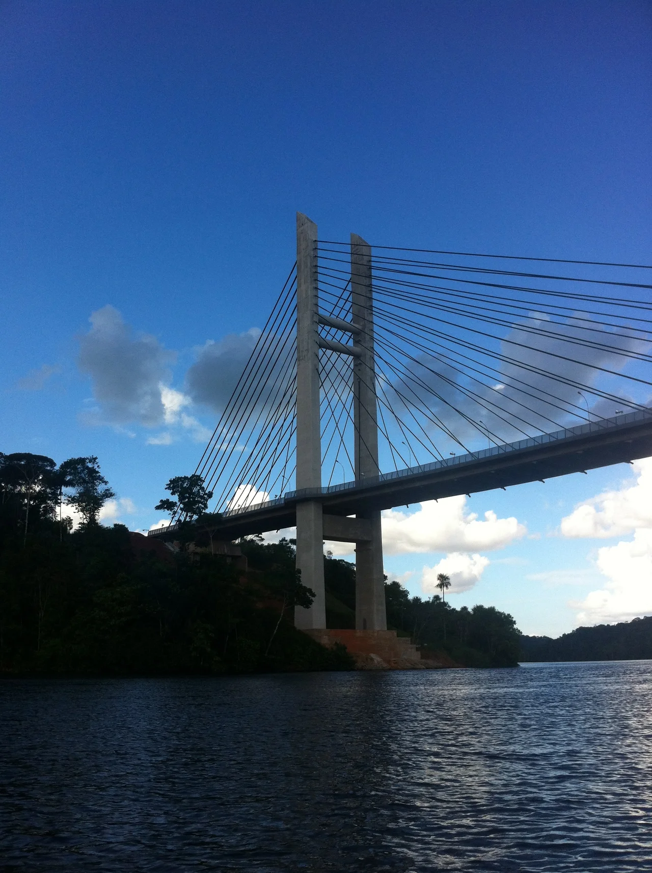
The Oyapock River does something unusual: it forms an international border between France and Brazil. France, in this context, means an overseas department on the coast of South America, and the border is seven thousand kilometers from Paris. On the French bank is Saint-Georges, also called Saint-Georges-de-l'Oyapock — a small, lively river town where a detachment of the French Foreign Legion keeps office hours, the signs are in French and the menus are in French and Portuguese, and crossing into Brazil used to mean hopping into a wooden canoe with an outboard. That changed in 2017, when a 378-meter cable-stayed bridge over the Oyapock finally opened after nearly a decade of finished concrete waiting for the diplomats to sort out how it would be used.
The Border Everyone Forgot
For most of its existence, Saint-Georges was what you had to pass through if you wanted to cross between French Guiana and the Brazilian state of Amapá by boat. The town across the river, Oiapoque, sits a few kilometers upstream on the Brazilian side. The two settlements grew up as mirror-image river ports, connected by a regular canoe traffic of traders, smugglers, day laborers, and the occasional backpacker who had come down the BR-156 highway through Amapá and wanted to see what the other side looked like. Immigration procedures were improvised: find the office, hope it was open, get the stamp if you could. The border's informality suited everyone and no one.
The Bridge That Took Nine Years to Open
Construction of the Oyapock River Bridge finished in 2011. It took another six years to open. Both countries had built their halves, but the binational protocols — immigration, customs, currency rules, vehicle requirements, cross-border policing — turned out to be harder than the concrete. The bridge sat empty. Rain fell on it. Foliage crept up the approaches. Finally, in March 2017, the first vehicles crossed. As of 2025, crossing the Oyapock by boat is no longer legal if you plan to continue deeper into either country. Local residents still hop back and forth by canoe under a kind of tolerated ambiguity, but the bridge is now the front door. The crossing may close at night and very early in the morning, but it operates nearly all day.
What It's Like to Cross
You can walk across the bridge, and if you want to understand the geography of the border you should. The approaches from either town are long, and the walk from the populated part of Saint-Georges to the populated part of Oiapoque is a two-hour proposition. The practical approach is to take a taxi from Saint-Georges to the French immigration checkpoint at the foot of the bridge, walk the twenty-plus-minute span itself across the river, clear Brazilian immigration on the other side, and continue by taxi or hitchhiking from there. Some of the French border police have a reputation for being friendly to hitchhikers, which is not a phrase typically associated with border police anywhere. There is no local public transport between the towns. Rental cars have historically been a problem at the border; check before assuming a particular vehicle is permitted across.
A Town in Its Own Right
Even with the bridge bypassing its waterfront, Saint-Georges remains a real place rather than a checkpoint. The Foreign Legion detachment has its quarters in town. The town hall — the Mairie — occupies a colonial-era building at the center of the small grid of streets, facing the square where the Saturday market takes place. The river itself is the main attraction: fishing, kayaking, and rafting are the standard offerings, and the Oyapock is wide enough and swift enough to reward an afternoon on the water. There is an airstrip but no scheduled passenger flights. From Cayenne, French Guiana's capital, the approach is by bus — with a transfer in Régina — or by car along the Route nationale 2, which is the only significant road running east from the Cayenne region. The road, to put it mildly, does not serve many towns in between. Régina and the Hmong village of Cacao in the Roura commune are essentially the only waypoints.
What the Oyapock Connects
Saint-Georges is a small town carrying a disproportionately large geographical significance: the only officially sanctioned land border between the European Union and Brazil, a fifty-meter-wide river separating two currencies, two legal systems, two languages, and two continents' worth of history. The crossing is not busy by the standards of international borders. A few hundred legal crossings a day, some cargo, a trickle of tourists mostly coming or going overland between Macapá and Cayenne. From the air, the arrangement reveals itself clearly: the green expanse of rainforest, the brown sinew of the river, the pale concrete span across it, and, on either side, the small river towns whose residents have, for generations, understood the border as mostly a technicality.
From the Air
Coordinates 3.891°N, 51.802°W, on the French-Guianese bank of the Oyapock River. Recommended viewing altitude 2,000–3,500 feet to see the 378-meter cable-stayed Oyapock River Bridge spanning the border, with Oiapoque, Brazil a few kilometers upstream. Nearest active airport with passenger service is Cayenne–Félix Eboué (SOCA) about 190 km northwest by road; Macapá International (SBMQ) in Brazil lies 480 km south. Equatorial climate year-round; the river is broad and often hazy at dawn.
Nearby Stories
- Salvation Islands 121 km away
- Oyapock 195 km away
- Saint-Laurent-du-Maroni 251 km away
- Paramaribo swamp forests 469 km away
- Guajará Bay 650 km away
- 2025 United Nations Climate Change Conference 678 km away
- Ver-o-Peso 683 km away
- Nadir Crater 3823 km away