Guajará Bay
The Tupinambá called it Paraná-Guaçu, the Great River-Sea, which captures it better than the Portuguese name that replaced it. Guajará Bay is not really a bay in the ordinary sense. It is a wide brown meeting-place where the Guamá and Acará rivers end and where their combined flow pushes north toward Marajó Bay and the Atlantic. The water rises and falls twice a day with the ocean tide pushing hundreds of kilometers up the Amazon. It has been, for at least four centuries, the front door of the entire eastern Amazon, the water you had to cross to reach anywhere important, and on January 12, 1616, three small Portuguese ships crossed it for the first time.
The Ships
The fleet was modest by European standards: the patache Santa Maria da Candelária, the caravelão Santa Maria das Graças, and the large speedboat Assunção. Aboard were 150 men, led by Captain Francisco Caldeira Castelo Branco, who took the grandiose title of Discoverer and First Conqueror of the Amazon. They dropped anchor at what the native Tupinambá called Mairi, on the eastern shore of the bay. The engineer-major Francisco Frias de Mesquita went ashore and began laying out the Forte do Presépio, a wooden fortification that would give the new settlement a defensible position. Castelo Branco called the place Feliz Lusitânia. The problem, from a Spanish legal perspective, was that under the 1494 Treaty of Tordesillas, the entire Amazon basin belonged to Spain. The solution was the Iberian Union, the temporary dynastic merger that had joined the two crowns in 1580, making the distinction functionally irrelevant.
The Battles
The fort had to earn its keep almost immediately. In the decades after 1616, Guajará Bay was contested water. Dutch, English, and French ships pushed into the estuary looking to establish trading posts and alliances with indigenous groups, seeking access to the spices, hardwoods, and medicinal plants known collectively as the drogas do sertão. None of them succeeded in settling permanently on the bay. The Portuguese pushed them steadily northward until they found themselves in the Guianas, where their descendants remain: French Guiana, Suriname, and Guyana exist in part because the Portuguese kept the Amazon mouth and nobody else could break through. The bay was the gate, and the gate held.
The Ecosystems
Guajará Bay is tidal freshwater, not salt. Mangroves line the quieter shallows. Igapó, the seasonally flooded forest that is one of the signature ecosystems of the Amazon, fringes the river mouths. Floodplain várzea spreads behind the levees. The surrounding upland is tropical rainforest, the Atlantic Forest giving way to the Amazon biome. The insular portion of Belém municipality, a scatter of 42 islands totaling 329.9 square kilometers, lies offshore in the bay; these are the islands that supply açaí to the city's famous waterfront market every morning. The largest and most visited is Mosqueiro Island, an 11,000-hectare land mass to the north of Belém whose 17 kilometers of beaches draw weekend crowds escaping the capital's equatorial heat.
The Name Mosqueiro
There is a specific story behind Mosqueiro's name that has nothing to do with mosquitos. The Tupinambá who lived on the island had developed a technique for preserving fish called moqueio, in which fish were smoked on wooden racks over low fires. A moqueio was the structure where this smoking happened. Early Portuguese writers adopted the word, spelled it Mosqueiro, and applied it to the island where the practice was widely observed. The name has survived for four hundred years. The fish smoking has mostly not. Today Mosqueiro is a resort district, connected to Belém by the Governador Almir Gabriel Bridge, but the etymology holds: the word on the maps is a Tupi-Guarani word from a vanished culinary technique.
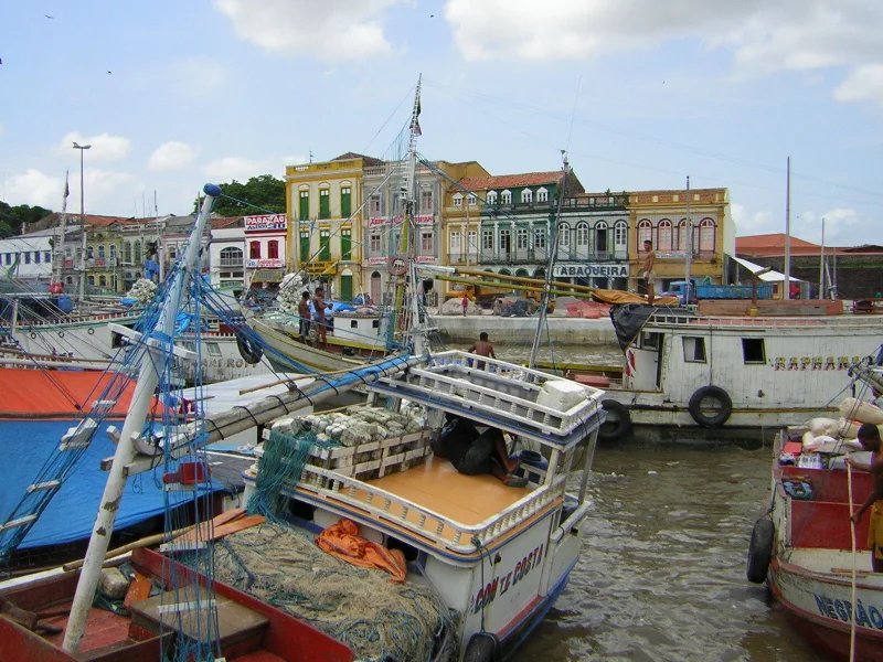
Present Pressures
The bay that was once a highway of empire is now a working harbor and a compromised ecosystem. Water pollution from disorderly coastal occupation and inadequate sanitation, mangrove loss, and sedimentation are the familiar problems of a bay adjacent to a metropolitan area of more than a million people. The city's growth has pushed up against and sometimes into the water, informally and unplanned. Pará state authorities and environmental organizations run conservation and awareness programs, creating protected zones and undertaking reforestation, though the pressures persist. The fair at Ver-o-Peso, the sheds along the Avenida Boulevard Castilhos França, the cruise ships that occasionally call at the port, all depend on the water. The water has a long memory. It knows what passed this way before.
From the Air
Guajará Bay lies at 1.4310°S, 48.5154°W, immediately west of downtown Belém. From altitude the bay reads as a wide tidal basin with three visible river mouths (Guamá from the east, Acará from the west, and the bay outflow to the north toward Marajó Bay), bordered by Belém's dense urban waterfront on the east and the island forests of Mosqueiro and Combu to the west and north. Recommended viewing altitude 3,000-5,000 feet. Nearest airport is Belém/Val de Cans International (SBBE), 7 km northeast. The bay's brown-white water contrasts sharply with the surrounding green forest from the air.
Nearby Stories
- São Miguel do Guamá 40 km away
- Santa Inês 344 km away
- Parcel de Manuel Luís Marine State Park 390 km away
- Xingu-Tocantins-Araguaia Moist Forests 396 km away
- Baixada Maranhense Environmental Protection Area 410 km away
- Marabá, Pará 432 km away
- USS Chiron 448 km away
- Oyapock 621 km away