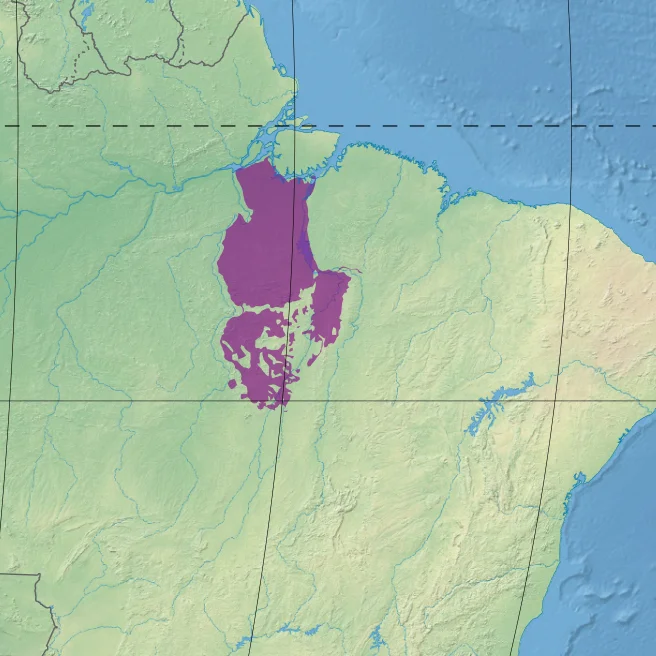
Xingu-Tocantins-Araguaia Moist Forests
The Trans-Amazonian Highway slices straight through it, and you can trace the damage from the air. On either side of the BR-230, the forest has been scraped back to pasture and soybean, and what remains has been stripped of its biggest trees. Between the Xingu River on the west and the Tocantins on the east, a 26-million-hectare ecoregion carries a grim distinction: after the Tocantins-Pindare forests next door, this is the most deforested corner of the Amazon. But fly low enough, or follow the blackwater tributaries upstream, and the other story emerges - jaguars, hyacinth macaws, spider monkeys, and river dolphins still moving through forest that refuses to surrender.
Between Two Rivers
The ecoregion is defined by water. The Xingu draws its western boundary and the Tocantins its eastern, both great rivers running south to north, draining the Brazilian Shield into the Amazon. Between them, the Araguaia carves its middle and lower basin through the heart of the region before joining the Tocantins. These are blackwater rivers, stained the color of strong tea by tannins leached from decaying leaves, carrying little sediment, reflecting the sky like polished obsidian. Smaller rivers braid off them - the Pacajá, the Anapu, the Bacajá, the Fresco, the Parauapebas, the Catete - each one lined with white-sand igapó forests that flood for months each year. The land tilts gently from sea level near the Amazon to 396 meters at the Carajás Mountains in the south, where the forest begins to break apart into cerrado and seasonal woodland.
Forests Planted by Hands Long Gone
The rainforest here is drier than the forests further west, and it shows. The canopy reaches forty meters in the north but thins southward, and there are fewer epiphytes clinging to the trunks, fewer orchids spilling from the branches. Liana forests cover large tracts of the richer southern soils - more open than true terra firme rainforest, the canopy dropping to twenty-five meters, the understory crowded with huge vines from half a dozen plant families. In some places the forest is dominated by babaçu palms or stands of Brazil nut, and scientists suspect the babaçu groves were originally planted by people - the signature of an agriculture that predates the highway by centuries. The endemic trees have names that read like a roll call of this place alone: Cenostigma tocantinum, Ziziphus itacaiunensis, Bauhinia bombaciflora.
What Still Moves in the Trees
Biologists have catalogued 153 mammal species here - modest by Amazon standards, but 90 of them are bats and the rest include jaguars, cougars, South American tapirs, and white-lipped peccaries that move in herds of fifty or more. Eight species of primates live in the canopy, among them the white-cheeked spider monkey and Azara's night monkey, both endemic to this ecoregion and the Tapajós-Xingu forests just to the west. The bird list runs to 527 species. Hyacinth macaws, the largest parrots in the world, flash cobalt blue against the green. Scarlet macaws, egrets, hawks, falcons, and parakeets fill the soundscape. In the blackwater rivers below, giant otters hunt in family groups, Amazon river dolphins surface to breathe, and black caimans - reaching five meters - slide through the shallows.
The Highway and the Smelter
The Trans-Amazonian Highway was cut through in the 1970s as a nationalist dream of integration, and it opened the forest to everything that has happened since. BR-230 runs west to east across the ecoregion; BR-422 runs north to south along the Tocantins. The land adjacent to both roads has been cleared for pasture and cropland. What forest remains has been high-graded for its most valuable species - mahogany, ipê, jacaranda - and many of the species that depended on them have gone locally extinct. Near Marabá, the Carajás iron mine, one of the largest in the world, pulls ore from the mountains and feeds smelters that demand endless tons of wood charcoal. Between 2004 and 2011 the ecoregion lost habitat at 0.94 percent per year. The World Wildlife Fund classes it Vulnerable. Warming temperatures will push tropical species upslope in search of cooler ground, but in a flat, deforested basin there is nowhere for most of them to go.
What Remains
Conservation has not surrendered. The Tapirapé Biological Reserve and Tapirapé-Aquiri National Forest hold intact forest in the south, near the Carajás range, and smaller reserves and indigenous territories preserve pockets elsewhere. The populated river towns - São Félix do Xingu on the Xingu, Marabá on the Tocantins, Porto de Moz near where the Xingu meets the Amazon - are staging points for both the destruction and the resistance. From the cockpit of a small plane, the pattern is unmistakable: roads run straight through the green, and the forest unzips in neat rectangles along them. But off the roads, the blackwater rivers still wind through country where, if you listened from a canoe at dawn, the howler monkeys would tell you the forest is not yet finished speaking.
From the Air
Centered roughly at 4.71 S, 50.86 W in the eastern Amazon basin of Pará state, Brazil. The ecoregion spans from near sea level along the Amazon to 396 m in the Carajás Mountains to the south. Visual landmarks include the Xingu and Tocantins rivers on the west and east flanks and the Trans-Amazonian Highway (BR-230) running east-west. Nearest airports: Carajás (SBCJ) and Marabá (SBMA). Cruise at 8,000-12,000 ft for the best view of the river network; expect tropical haze and heavy afternoon convective buildups year-round.
Nearby Stories
- Tapirapé-Aquiri National Forest 99 km away
- Carajás National Forest 127 km away
- Marabá, Pará 150 km away
- Serra do Pardo National Park 206 km away
- Terra do Meio Ecological Station 255 km away
- Tapajós–Xingu moist forests 371 km away
- Ver-o-Peso 382 km away
- Guajará Bay 416 km away