Carajás National Forest
U.S. Steel prospectors went looking for manganese in the 1960s and stumbled into something else entirely: a mountain range sitting on one of the richest iron ore deposits ever found. The accidental discovery beneath the Serra dos Carajás set in motion everything that followed - the displacement of communities, the building of a thousand-kilometer railway, and eventually, the odd legal creation of a national forest that exists largely to keep one mining company's trucks rolling. Fly over today and you see both Amazons at once: emerald canopy stretching to the horizon, and a red-orange wound where humanity extracts the iron that becomes the world's steel.
The Accidental Discovery
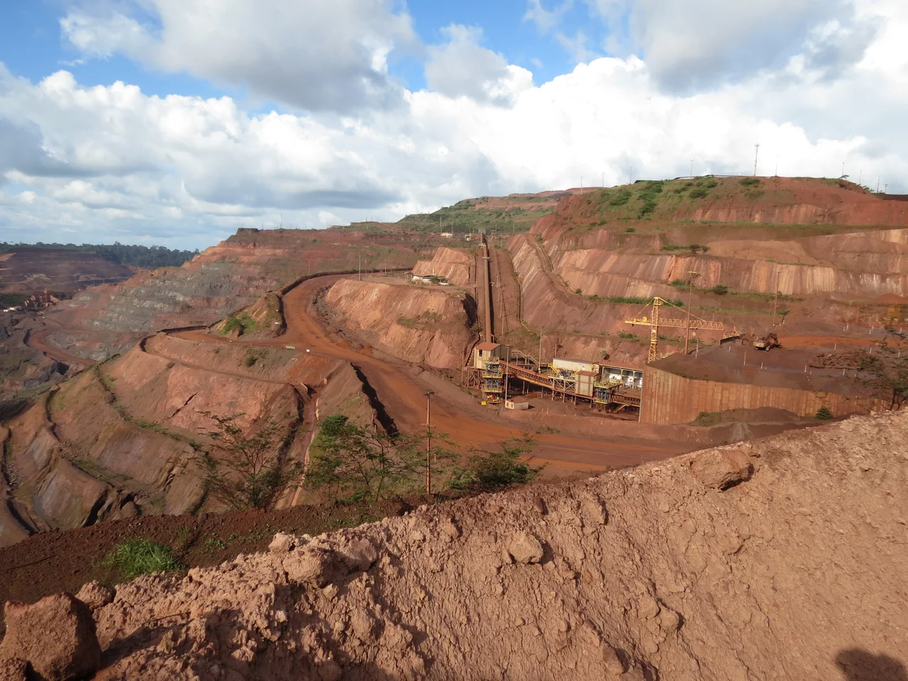
The story sounds like something invented for a documentary, but it actually happened. A U.S. Steel helicopter, grounded by weather atop a flat mountain in the eastern Amazon, led geologists to notice the distinctly rust-colored rocks underfoot. The Serra dos Carajás - a complex of mountains stretching roughly 160 kilometers, their tops curiously flat at 620 meters and above - turned out to be one of Earth's greatest iron ore repositories, along with substantial manganese reserves. A joint venture formed in 1970, with the Brazilian mining giant Vale holding 51 percent and U.S. Steel the remainder. By 1977, Vale had bought out its American partner entirely. Mining began in 1985, and it has not stopped since. In 2008 alone, the Carajás Mine produced 301 million tonnes of iron ore.
A Forest Drawn Around a Mine
The national forest designation, on paper a triumph of Amazon conservation, came with an asterisk. Decree 2.486, signed on 2 February 1998, created a protected area of roughly 412,000 hectares - but the creation also served a quieter purpose. By designating the zone as a national forest rather than a strict reserve, the Brazilian government avoided the requirement to submit the mining concession to a congressional vote. The IUCN classifies Carajás as a Category VI protected area, meaning sustainable use of natural resources is explicitly permitted. The forest is administered by the Chico Mendes Institute for Biodiversity Conservation, named for the rubber tapper assassinated in 1988 for defending the Amazon - a name that sits uncomfortably on a territory defined around the world's largest iron operation.
Life Above the Iron
Vale occupies roughly three percent of the concession area. The remaining ninety-seven percent remains forested, which is why Carajás has become one of the better-studied biodiversity hotspots in the Amazon. Researchers have catalogued 594 bird species, 131 reptiles, 68 amphibians, and 44 large and medium-sized mammals across the reserve. The protected list includes the jaguar, Panthera onca, still the apex predator of this rainforest, and Uta Hick's bearded saki - a small primate with a characteristic beard and a range so narrow that Carajás holds nearly its entire known population. The company runs the Vale Zoo and Botanical Park, open to the public, a gesture toward the sustainable mandate that accompanies the extraction.
The S11D Expansion
In March 2012, Vale announced it had secured an installation license for the S11D project, the largest capital expenditure in the company's history at 19.671 billion US dollars. S11D extended the mining footprint into new areas of the Serra dos Carajás, deepening the central tension that has defined this place since the first helicopters landed. Canaã dos Carajás, a municipality that barely existed before the 1980s, swelled into a mining boomtown of tens of thousands. Roads, rail, and riverine infrastructure radiated outward, changing land use across eastern Pará. Critics argued that "sustainable use" had become a legal veneer for industrial transformation. Supporters pointed to the genuine protection of the forest canopy across the overwhelming majority of the concession.
Green Lungs, Red Earth
Flying over Carajás, the scale of the paradox is immediate. The mine's terraced pits spiral into the earth in geometric rings, their reddish iron-rich soil a sharp contrast to the dense green around them. Beyond the pit, the forest extends largely intact, ringed by the Tapirapé-Aquiri National Forest, the Tapirapé Biological Reserve, and the Gelado Environmental Protection Area - a continuous block around the Carajás Mineral Province that, on a satellite map, reads as one of the Amazon's better-defended regions. Whether that defense can hold as extraction expands, and whether the communities displaced by decades of mineral development will ever share equitably in the wealth extracted from beneath them, remain the open questions of this strange, ambiguous place.
From the Air
Centered at 6.06°S, 50.17°W in the state of Pará, Brazil. Best viewed from 8,000-12,000 feet AGL - the flat mountain tops are distinctive from altitude, and the Carajás Mine's terraced iron pits appear as a bright red-orange spiral surrounded by deep green canopy. Serra dos Carajás Airport (SBCJ, ICAO CJS) sits at Parauapebas, just north of the forest. Weather is consistently warm (21-28°C) with heaviest rains December through April.
Nearby Stories
- Tapirapé-Aquiri National Forest 33 km away
- Marabá, Pará 69 km away
- Serra dos Martírios/Andorinhas State Park 115 km away
- Xingu-Tocantins-Araguaia Moist Forests 124 km away
- Juscelino Kubitschek de Oliveira Bridge 235 km away
- Serra do Pardo National Park 321 km away
- Chapada das Mesas National Park 335 km away
- Pan Am Flight 202 381 km away