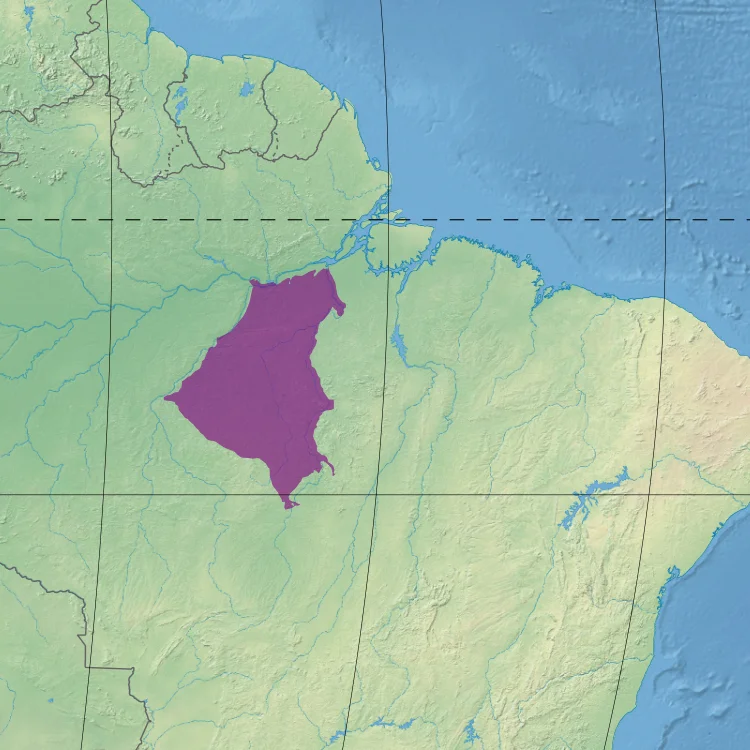
Tapajós–Xingu moist forests
The rivers decide who lives where. A white-nosed saki monkey, with its distinctive pale snout and black body, is common throughout the Tapajos-Xingu moist forests - and nowhere else. Cross the Tapajos River to the west, and it vanishes. Cross the Xingu to the east, and it is gone again. For this ecoregion's endemic species, these two enormous tributaries of the Amazon are not just landscape features. They are the edges of the world. This is biogeography at its most literal: 336,698 square kilometers of forest between two natural barriers that have shaped evolution for millions of years.
The Shape of the Land
The ecoregion sits in the eastern Amazon basin, wedged between the Tapajos River to the west and the Xingu to the east. To the north lies the main stem of the Amazon itself, with the port city of Santarem marking the mouth of the Tapajos. To the south, the rugged Serra do Cachimbo marks the ecoregion's boundary - a line of low mountains that act as another barrier to the movement of species. Elevations range from a mere 5 meters along the Amazon floodplain to 198 meters in the south. The terrain rides on the ancient Brazilian Shield, its soils often surprisingly rich in nutrients, though the higher elevations tend toward poorer substrate. Almost all the major rivers running through the ecoregion are blackwater - dark with tannins leached from decaying plant matter, clear of suspended sediment, stained the color of strong tea. The largest is the Iriri, a tributary of the Xingu.
An Equatorial Rhythm
The climate here runs on an equatorial monsoon schedule. Temperatures vary little - slightly cooler in July, slightly warmer in April, with an annual mean just under 27 degrees Celsius. What changes dramatically is the rain. February brings 313.9 millimeters on average, a torrential wet-season peak. July brings just 37.7 millimeters, during what functions here as a dry season. Rain falls on roughly 240 days of each year. This steady warmth and heavy rainfall supports a forest that is mostly evergreen, mostly terra firme - not subject to flooding - and mostly intact in the areas most distant from roads. Along the riverbanks, where the blackwater rivers overflow seasonally, forests flood annually and develop into what Brazilians call igapo - forests where trees grow directly from the water during the wet months, their trunks ringed with dark tidemarks when the water recedes.
Life Between the Rivers
Biologists have recorded 161 species of mammals and 556 species of birds in the ecoregion, with more likely waiting for a formal description. Beyond the white-nosed saki, the forest holds the red-bellied titi, the white-cheeked spider monkey, the collared peccary, the jaguar, and the South American tapir. The rivers are home to the spectacled caiman and the much larger black caiman, Amazon river dolphins known as botos, and Amazonian manatees. Among the birds, seven species of macaw include the hyacinth macaw - the largest flying parrot in the world, cobalt blue and unmistakable. The hoatzin, that strangest of birds that smells like cow manure and whose chicks have claws on their wings, nests along the blackwater streams. The harpy eagle - one of the world's most powerful raptors - hunts sloths and monkeys in the canopy. Endemic trees include Cenostigma tocantinum and Ziziphus itacaiunensis, names that read like coordinates of a very particular botanical neighborhood.
A Vulnerable Ecoregion
The World Wildlife Fund classes the Tapajos-Xingu moist forests as Vulnerable, along with the adjoining ecoregions to the east. Roads are the primary reason. Once a highway cuts through the forest, colonists follow, then loggers, then ranchers, then the major infrastructure projects that finish the job. Between 2004 and 2011, the ecoregion lost 0.38 percent of its habitat every year - a rate that compounds into something catastrophic across decades. Miners working informal gold operations pollute the rivers with mercury, the same poison that made Serra Pelada notorious downstream. Global warming adds another threat: tropical species under climate stress typically migrate uphill to cooler elevations, but flat, low ecoregions like this one offer almost no uphill to migrate to. Amazonia National Park protects both banks of the Tapajos near Itaituba across nearly 10,000 square kilometers, but it is chronically underfunded. Tapajos National Forest does little to protect the land near Aveiro. The forest stands. For how long depends on choices still being made.
From the Air
The Tapajos-Xingu moist forests ecoregion is centered near 5.91 S, 54.44 W covering approximately 336,700 square kilometers between the Tapajos and Xingu rivers in Para, Brazil. Elevations mostly under 200 meters. Expect dense forest canopy with river courses as primary visual reference - particularly the Iriri, Jamanxim, Crepori, Curua, and Curua Una. Urban centers at Santarem (SBSN/STM), Aveiro, and Altamira (SBHT/ATM) provide airfield options. Recommended viewing altitude 5,000 to 8,000 feet AGL to appreciate the river geometry. Expect daily convective activity and afternoon thunderstorms year-round, with wet season (October through April) bringing particularly heavy rainfall.
Nearby Stories
- Altamira National Forest 35 km away
- Serra do Pardo National Park 89 km away
- Jamanxim National Forest 184 km away
- Terra do Meio Ecological Station 187 km away
- Tapajos Hydroelectric Complex 196 km away
- Fordlândia 239 km away
- Tapajos Environmental Protection Area 268 km away
- Gol Transportes Aéreos Flight 1907 480 km away