Papenburg
Papenburg is a seaport with no sea. It sits about forty kilometers up the river Ems from the North Sea coast, in the flat peat country where Germany blurs into the Netherlands, and yet the title is technically correct - the Ems is deep enough here that ocean-going ships can reach the town, making Papenburg Germany's southernmost saltwater port without a coastline. Canals lace the old center. Sailing-ship replicas, polished and stubborn, are tied up along the quays as if the nineteenth century never quite ended. And on the northern edge of town, behind chain-link fence, sits one of the largest enclosed shipbuilding halls on the planet, where cruise liners are assembled in a place that looks, from any approach road, like nowhere a cruise liner should be.
A City Built on Peat
Papenburg began in the 1630s as a Fehnkolonie - a peat colony - one of a chain of settlements stretched across the bogs of the Dutch-German borderland. The model came from across the border, in the Veenkoloniën of Groningen: cut a canal into the moor, drain the surrounding bog, harvest the peat for fuel, and use the canal to ship the dried turf to market. The canal becomes the village's main street. The houses face the water. Centuries later the peat is mostly gone but the canals remain, threading through the districts of Untenende, Obenende, and Aschendorf - the last of which was already an old settlement when Papenburg itself was founded. Each district kept its own character. Walking from one to another, you can feel the town's history broken into chapters.
Sailing Ships in the Canals
Out of the peat trade came shipping. Out of shipping came shipbuilding. By the nineteenth century Papenburg had more than twenty shipyards along the Ems and its branches, building wooden brigs and schooners for North Sea trade. Many of those yards are gone now, but the town keeps the memory afloat. Tied up in the canals are sailing-ship replicas - the Thekla von Papenburg among them - working museums of what the place used to make. The water around the old center is shallower than it looks. It was never about depth. It was about getting a hull launched, floating it to the Ems, and pushing it out toward the open coast.
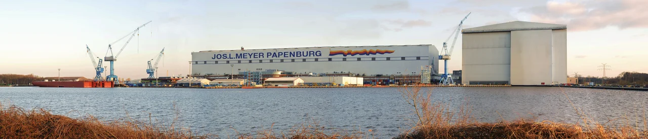
What the Big Hall Hides
The Meyer Werft shipyard, founded here in 1795 by Willm Rolf Meyer to build small wooden vessels, never left. Seven generations of Meyers later it is one of the most modern shipyards in the world, employing more than 3,450 people in halls so large that the cruise ships are essentially built indoors, weather-proofed against the long North German winter. The biggest of those halls is among the largest enclosed buildings on Earth by usable volume. From a distance the structures look like flat-roofed warehouses; only when you compare them to the small town around them does the scale register. The shipyard is now an anchor site on the European Route of Industrial Heritage - an admission, in effect, that Papenburg's industrial present is already a historic monument.
The Long Ride to the Sea
When a finished ship leaves Papenburg, the whole region pays attention. The hull has to travel about thirty-six kilometers down the Ems, stern-first, towed and nudged through a river that is narrower than the ship is long. People line the banks. Cars park along the dikes for hours. The conveyance can take more than a day depending on tides and on the Ems barrage - a movable barrier completed in 2002 that lets the water be dammed up to float the hulls free. Before the barrage, the trip had to be timed to natural high water and the available window was brutally short. Now the engineering is a little kinder, but the spectacle has not faded. The ships are too big for the river, and that is part of why people come.
Around the Edges
Beyond the shipyard, Papenburg keeps its everyday rhythms. There are bike routes in every direction - the Ems-Radweg, the Deutsche Fehnroute, the Dollard Route - that thread through the canal-lined neighborhoods and out into the peat-and-pasture countryside. Cyclists from the Netherlands cross the border so casually that mobile phones drift onto Dutch networks before anyone notices. South of town, in the village of Heede, stands the so-called dicke Linde, a linden tree estimated at six to eight hundred years old, its trunk close to seventeen and a half meters around - a single living thing that has stood through Papenburg's entire transformation from peat moor to cruise-ship capital.
From the Air
Papenburg sits at 53.07°N, 7.40°E on the south bank of the Ems, about 10 km east of the Dutch border. From cruising altitude the shipyard's enormous building halls are unmistakable - flat white rectangles dwarfing the town beside them. Recommended viewing altitude 2,500-5,000 feet. Nearest airports: Groningen Eelde (EHGG) about 55 km west, Bremen (EDDW) about 95 km east, Münster Osnabrück (EDDG) about 110 km south. Follow the Ems channel northward to see the famous river passage route the cruise ships take from yard to sea.
Nearby Stories
- Stadskanaal 5 km away
- Warsingsfehn 7.6 km away
- Dinklage 8.4 km away
- Delfzijl 11 km away
- 1st Panzer Division (Bundeswehr) 14 km away
- Varel 15 km away
- Meppen 19 km away
- Coevorden 20 km away