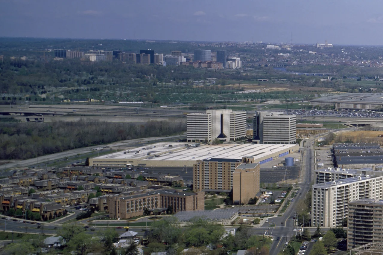

Pentagon City
When Morris Cafritz and Charles H. Tompkins bought 190 acres in southeast Arlington for $1.5 million in 1946, the parcel was mostly empty fields and warehouses. The Pentagon, a five-sided monster of a building that had been completed five years earlier, dominated the immediate skyline to the north. Arlington National Cemetery sat just beyond. The Potomac River ran a mile east. The land had no name. The developers called what they were planning Pentagon City. For most of the next thirty years, the development moved slowly - a Western Electric telephone manufacturing plant in the 1950s, a few high-rise apartment buildings in the 1960s on Hayes, Fern, and Joyce Streets. The real transformation began on July 1, 1977, when the Pentagon City Metrorail station opened on the Blue Line. The empty field next to the new station rapidly filled with development. Forty-eight years later, Pentagon City is one of the densest, busiest, and most economically consequential districts in the Washington region.
Cafritz Buys the Fields
The Pentagon was completed on January 15, 1943 - a wartime emergency project designed by George Bergstrom and built in sixteen months. The building's footprint covered 29 acres; its five concentric rings of corridors stretched 17.5 miles in total length. Around it, much of southern Arlington remained farmland and brownfield. Real estate developer Morris Cafritz, who had built much of the residential D.C. that arose between the two world wars, partnered with Tompkins to acquire a 190-acre block south of the Pentagon in 1946. The price was $1.5 million. The plan was speculative - the developers expected federal employment to keep growing around the Pentagon, and they expected suburban housing demand to follow. Through the late 1940s and 1950s, the land slowly developed in a piecemeal pattern. Western Electric opened a telephone manufacturing facility on part of the property in the 1950s. That facility was later converted to a small shopping mall called Pentagon Centre. High-rise residential buildings began appearing in the 1960s.
The Metro Station and the Mall
The opening of the Pentagon City Metro station on July 1, 1977, transformed the development calculus. The Washington Metro - then in its first decade - was establishing the high-density development patterns that would shape the entire region. Pentagon City sat at the intersection of the Blue Line (and later the Yellow Line), one station south of the Pentagon itself, with direct connections to downtown Washington. Within ten years, the empty field next to the station had filled with development. The Fashion Centre at Pentagon City, a four-story enclosed shopping mall topped by the twelve-story Washington Tower office building, opened in 1989. The Fashion Centre became one of the highest-grossing malls per square foot in the region, drawing both local residents and the considerable tourist traffic generated by the nearby Pentagon and the National Mall a Metro ride across the Potomac. MCI Communications occupied the Washington Tower office space in the 1990s as its Consumer Markets headquarters. The Pentagon City Metro station became, and remains, one of the busiest in the Metro system.
The Baseball Stadium That Didn't Happen
In 2003, the Virginia Baseball Stadium Authority proposed five Northern Virginia sites as possible homes for the Montreal Expos, which Major League Baseball was preparing to relocate. Three of the five proposed sites were in Arlington County: Pentagon Centre, an undeveloped parcel closer to the Pentagon, and a site in Rosslyn. The Pentagon Centre proposal was divisive. Local residents organized a visible campaign against it - the Arlington Coalition for Sensible Transportation collected signatures, lobbied the Arlington County Board, and ran door-to-door campaigns. The Arlington County Board sided with the opponents and opposed all three Arlington locations. The final Virginia bid was for a site near Dulles International Airport. Major League Baseball ultimately announced in fall 2004 that the Expos would relocate to Washington, D.C. itself - becoming the Washington Nationals - and play in a new stadium on the Anacostia waterfront in Southeast D.C. Pentagon City's character as a residential and retail district was preserved; the city had narrowly avoided being transformed into a stadium neighborhood.
TSA, DEA, Amazon
The neighborhood's office stock has reflected its proximity to the Pentagon. The Transportation Security Administration is headquartered here. The Drug Enforcement Administration occupies a major office complex on Army Navy Drive, along with the DEA's Museum and Visitors Center. Defense contractors and federal agencies fill many of the surrounding buildings. The most consequential corporate arrival came in November 2018, when Amazon announced that Pentagon City - alongside the Long Island City neighborhood of New York City - would host one of two new East Coast headquarters, branded HQ2. Long Island City withdrew within months after political backlash. Pentagon City did not. Amazon began construction of its HQ2 campus, anchored by the Metropolitan Park development. The first two HQ2 buildings - the WAS17 Merlin and WAS19 Jasper towers - opened in 2023. The planned Helix building, designed as a spiraling glass structure, was announced for future development but remains paused as of 2026.
Robert A.M. Stern's Apartments
On Fern Street, next to the neighborhood's Costco store, the eight-phase Metropolitan Park development by Kettler has been replacing older warehouses with high-density residential buildings throughout the 2000s and 2010s. The first two phases - Gramercy at Metropolitan Park (completed in late 2007) and The Millennium at Metropolitan Park (late 2009) - were designed by Robert A.M. Stern. The pattern repeats across Pentagon City: high-rise luxury rentals and condos around the Fashion Centre, with names like The Metropolitan at Pentagon Row, Pentagon Row, Park View, the Southampton Condominium, and the Claridge House. Pentagon Row, on the west side of the Fashion Centre mall, includes a Whole Foods, smaller retailers, and an outdoor plaza that hosts an ice rink in winter and a free concert series in summer. Virginia Highlands Park, immediately south, provides green space, basketball courts, tennis courts, and softball fields. The Aurora Hills branch of the Arlington Public Library and a firehouse anchor the southern edge. South of the park, the residential character shifts to the single-family Aurora Highlands neighborhood. Two miles from the National Mall, a Metro ride from downtown, two miles north of Reagan National Airport - Pentagon City has become exactly what the 1946 developers imagined, only at multiples of the scale they could have foreseen.
From the Air
Pentagon City is centered approximately at 38.8639 N, 77.0594 W, in southeastern Arlington County, Virginia. Best viewed from 1,500 to 3,000 feet AGL. The Fashion Centre at Pentagon City Mall with its rooftop Washington Tower is the most distinctive visual element from above. The Pentagon's five-sided footprint sits immediately north. Reagan National Airport (KDCA) lies one mile east. The site sits inside the Washington Flight Restricted Zone; GA overflight prohibited. Pentagon City is the southern end of the Pentagon-to-Reagan National corridor of high-density development.
Nearby Stories
- Gunston Hall 1.1 km away
- 2023 Baltimore Shooting 4.9 km away
- Battle of Middleburg 6.6 km away
- Crownsville Hospital Center 10 km away
- Battle of Loudoun Heights 13 km away
- First Battle of Rappahannock Station 20 km away
- Howard County, Maryland 21 km away
- Harriet Tubman Underground Railroad 50 km away