
Pheneus
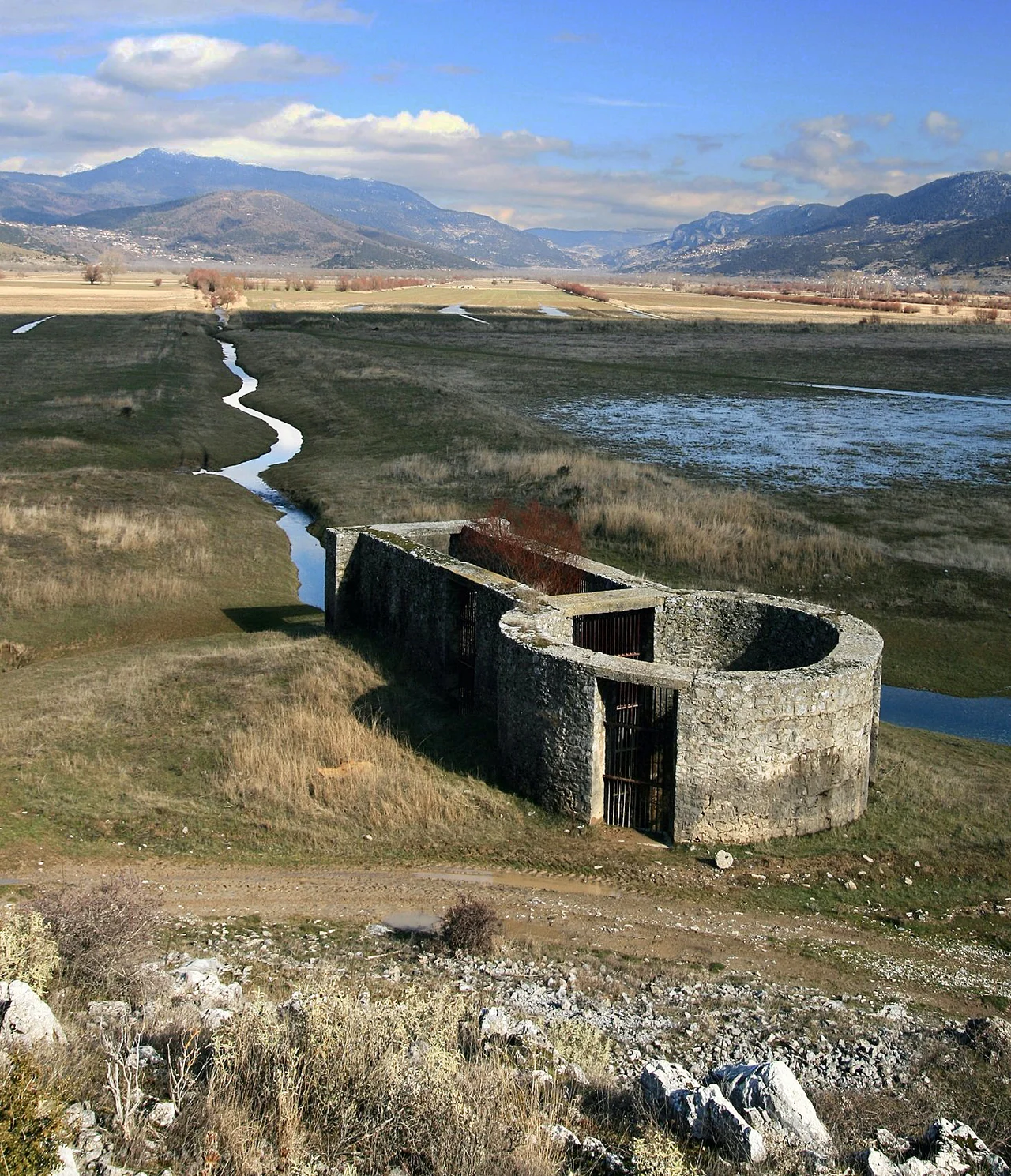
The plain of Pheneus has a problem that Heracles supposedly solved, and that reality keeps reversing. The valley is a closed karst basin — mountains on every side, no natural surface outlet for the water that collects in it. In antiquity, myth explained this with characteristic directness: Heracles had dug channels to drain the floods. Pausanias, visiting in the 2nd century AD, noted that the canal attributed to the hero had become useless and the river had resumed its ancient, irregular course. William Martin Leake, riding through in 1806, could still see one bank of the canal as a conspicuous feature of the landscape. In 1821 the underground drainage channels — the katavothres, the natural sinkholes in the limestone — became blocked, and water rose until it had destroyed a substantial area of cultivated land. It did not drain again until 1832, when the channels reopened and the floodwaters rushed down into the Ladon and the Alpheius, overflowing all the way to Olympia. Pliny the Elder had counted five such catastrophes in the ancient period alone.
Shut In On Every Side
Pheneus occupied the northeast corner of ancient Arcadia, its territory the Pheniatis bounded by the Achaean towns of Aegeira and Pellene to the north, the Stymphalia to the east, the Cleitoria to the west, and the Caphyatis and Orchomenia to the south. The territory was approximately twelve kilometres in length and twelve in breadth — compact, self-contained, and entirely hemmed in by mountain offshoots of Mount Cyllene and the Aroanian chain. Two streams descended from the northern heights and joined in the middle of the valley; the combined river bore the ancient names Olbius and Aroanius. What sounds like an idyllic enclosed valley was in practice a hydraulic trap. Without the katavothres — the natural limestone ponors that swallowed the collected water — the plain would simply fill. And the katavothres, unlike Heracles, could not be relied upon.
A City Famous for Its Myths
Pheneus was celebrated more in mythological literature than in political history. Homer listed it in the Catalogue of Ships in the Iliad — its forces led by Agapenor. Virgil, in the Aeneid, placed the exile Evander here, connecting Pheneus to the founding mythology of Rome itself. Its deepest association, however, was with Heracles: the canal, the drainage work, the hero's labour in a valley that nature refused to drain. When Pausanias arrived, he found a city in complete decay. The acropolis held a ruined temple of Athena Tritonia and a bronze statue of Poseidon Hippius. On the descent from the acropolis was the stadium; on a neighbouring hill, the tomb of Iphicles, the mortal half-brother of Heracles. The principal deity of the city was Hermes, and his temple was the most active surviving monument. A temple of Apollo Pythius stood 15 stadia north on the road to Achaea, already ruined in Pausanias's time. The road northwest led toward Nonacris and what the ancients associated with the river Styx — the icy waterfall on the slopes of Aroania that Pausanias described as cold enough to shatter stone vessels.
Roads in Every Direction
Despite its isolation, or perhaps because of it, Pheneus was a hub of mountain roads. Pausanias traced them carefully. North: through the Pheneatic plain toward Aegeira and Pellene, past the ruined Apollo temple. Northwest: toward Nonacris and the Styx. West: along Heracles's old canal and then over the mountain to Cleitor. South: through a narrow ravine — a φάραγξ, a gorge — toward Orchomenus, the road passing the village of Caryae between mountains named Oryxis and Sciathis, each with a subterranean channel draining water from the pass. East: across Mount Geronteium toward Stymphalus, past a mountain called Tricrena — the three fountains — and another called Sepia, where the mythical king Aepytus was said to have died from a snakebite. Each road had a story; each pass had a name. In a landscape where every valley was a world unto itself, the roads between them mattered enormously.
What the Yellow Line Means
Pausanias noticed a yellow discolouration on the mountain rock around the Pheneatic plain — a horizontal band at considerable height that the locals pointed to as evidence of the ancient flood level, proof that the water had once reached catastrophic depth. Pausanias was sceptical. He thought the line more likely resulted from the difference between rock that was regularly moistened near the base and rock that dried completely above — a differential weathering effect that would produce exactly such a colour change over time. He was probably right, and his reasoning is a small example of ancient empirical thinking at its best. But he also acknowledged the floods themselves were real. Eratosthenes had described a particularly severe event in which backed-up water eventually burst through the katavothres, rushed into the Ladon and Alpheius, and flooded the plain of Olympia. The 1821–1832 episode confirmed that such events were not simply mythological. The katavothres failed, the plain filled, and the ancient cycle repeated itself in modern times, in the same valley, in the same way.
The Modern Village on the Ancient Hill
The site of Pheneus is near the modern village of Archaia Feneos, formerly called Kalyvia, in the municipal unit of Feneos. Leake, visiting in 1806, identified the ruins on the insulated hill above the plain and mapped the remains of the ancient city. The identification of the exact acropolis location has generated some scholarly debate: Pausanias described it as precipitous on every side with only partial artificial fortification, but the surviving summit is modest and gently sloped. Leake suggested the whole hill served as the acropolis and that the lower town occupied the plain below. Whatever the precise configuration, the remains stand where Pausanias placed them — on a hill surrounded by the same karst-flooded plain, backed by the same ring of Arcadian mountains, in a landscape that has changed less than most of Greece and more than it sometimes appears.
From the Air
Pheneus lies at approximately 37.916°N, 22.296°E in the northeastern Arcadia uplands, within a closed karst basin clearly visible from altitude as an enclosed mountain valley with no surface drainage outlet. The plain appears flat and cultivated; the surrounding mountains are rugged limestone country. Nearest major airport: LGRX (Araxos/Patras), approximately 75 km to the northwest. Recommended viewing altitude: 6,000–10,000 feet to appreciate the enclosed basin topography and the ring of mountain passes that Pausanias described. The northwest road toward Nonacris and the Styx waterfall area of Mount Aroania/Chelmos is traceable as a valley corridor from this altitude.
Nearby Stories
- Siege of Corinth (1463) 2.1 km away
- Aigeira 2.7 km away
- Oblou Monastery 3.7 km away
- Isova 4.9 km away
- Mantinea 5.2 km away
- Arkadiko Bridge 8 km away
- 1981 Gulf of Corinth Earthquakes 11 km away
- Battle of Lalas 20 km away