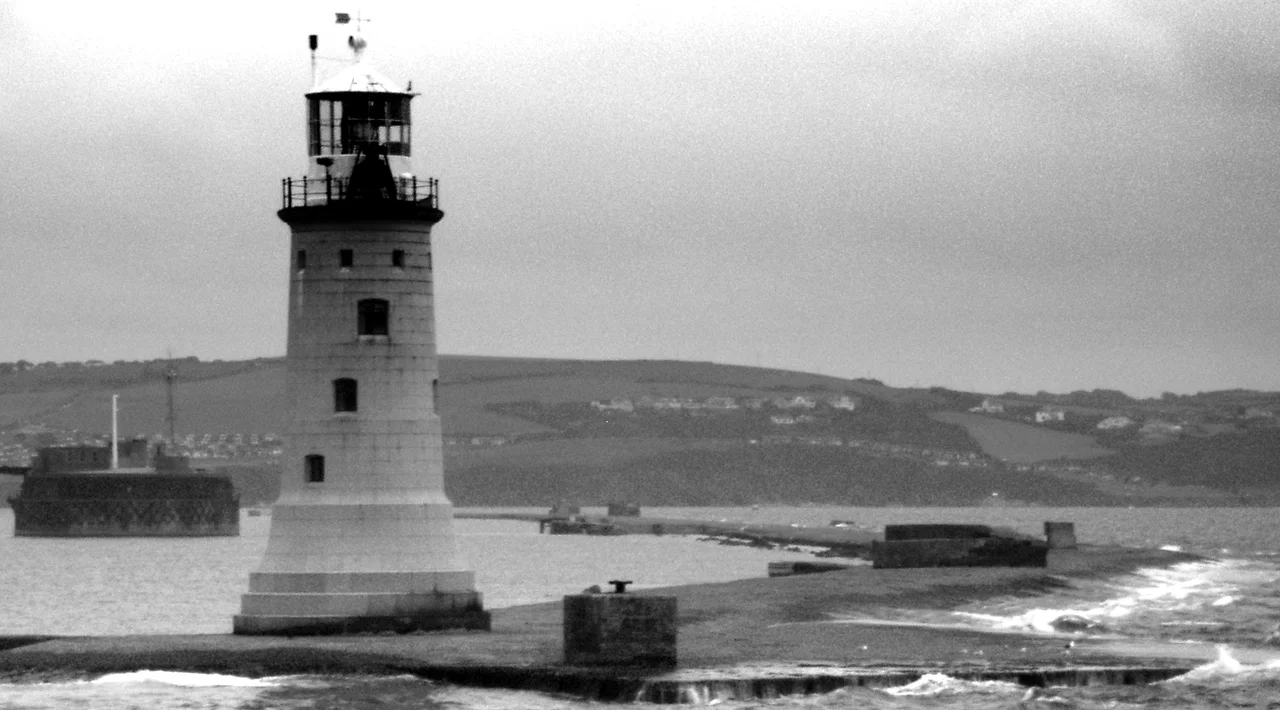

Plymouth Breakwater
Napoleon Bonaparte, sailing past on his way to permanent exile on St Helena in July 1815, looked out at the half-finished line of stone stretching across Plymouth Sound and called it a grand thing. He was the recently defeated emperor of the most powerful empire in Europe, and he knew engineering when he saw it. The Plymouth Breakwater was an act of national audacity. Four million tons of stone, quarried, shipped, and dumped into 10 metres of open water across a mile and a half of exposed sea. It was begun in 1812 as the Napoleonic Wars dragged on, conceived to make Plymouth Bay a safe anchorage for the Channel Fleet. It cost £1.5 million in the money of the day, an almost incomprehensible sum. And when Napoleon passed by, he was looking at the largest engineering project in Britain.
Lord St Vincent's Order
It was John Jervis, the Earl of St Vincent and former First Lord of the Admiralty, who commissioned the breakwater in 1806 as Napoleon's threat to Britain was reaching its peak. The Royal Navy needed a deep-water anchorage on the south coast where the Channel Fleet could shelter, refit, and watch for the French. Plymouth Sound was deep enough, wide enough, and well-placed, but it was exposed to the south-westerly storms that drove great seas through its mouth. A stone wall across the entrance, properly engineered, would convert the Sound into one of the largest sheltered harbours in Europe. St Vincent appointed John Rennie, the great Scottish civil engineer, and Joseph Whidbey, who had sailed with Vancouver on the Pacific voyages and knew the practicalities of harbour work, to plan the thing together. In 1811 the order to begin construction came down, and Whidbey was made Acting Superintending Engineer.
Four Million Tons
The foundation stone was laid on Shovel Rock on 8 August 1812. The construction method was straightforward in concept and almost unimaginable in execution: quarry the stone on shore, load it onto specially designed ships, sail to the line marked across the Sound, and tip the rock over the side. Repeat four million times. The fleet of about a dozen stone-carrying ships was innovatively designed by Rennie and Whidbey for the specific task. The quarrying yielded an unexpected bonus: Whidbey reported many fossils discovered as the rock was worked, and he wrote a paper for the Royal Society on the bones found in the limestone caves. By 1814, only two years in, the breakwater was already sheltering ships of the line. Storms in 1817 and 1824 forced changes to the profile and the height, the great seas teaching the engineers what they had not anticipated. John Rennie died in 1821 before the work was finished. His sons George and Sir John completed what their father had begun.
The Lighthouse at the Western End
Construction of the granite lighthouse at the breakwater's western tip began on 22 February 1841 and finished on 9 November 1843. The design came from Walker & Burgess for the Admiralty, with William Stuart superintending the build. The light is 23 metres above the sea. When Trinity House took over management, they fitted a second-order catadioptric lens array made by Henry Lepaute of Paris, showing a fixed red light with a white sector indicating the safe anchorage to the north-east. From 1854 a second white light was added lower in the tower, marking the channel between two shoals named the Draystone and the Knap. The fog bell sounded four strokes every minute when the sea was thick. In 1920 the lighthouse was converted to run automatically on acetylene gas, and the resident keepers departed for the last time. Today the main light still flashes once every ten seconds, white with a red sector to the north-east, watching ships into Plymouth as it has done for 180 years.
The Sea Fort in the Middle
In 1860 a Royal Commission established by Lord Palmerston produced a comprehensive plan for the defence of Plymouth and the other Royal Dockyards. The Breakwater Fort was the seaward keystone of that plan. Designed by Captain Siborne and begun in 1861, this oval masonry sea fort was built on Shovel Rock, 35 yards inside the breakwater itself, with its foundations driven into the same submerged ridge that anchored the eastern end of the wall. The main structure was completed in 1865. After several changes of plan it was finally armed in 1879 with fourteen 12.5-inch and four 10-inch rifled muzzle-loading guns in armoured casemates, an extraordinary concentration of firepower designed to dominate the entrance to the Sound. The fort was disarmed before the First World War but kept its uniform: it became a signal station, then from 1937 an anti-aircraft training school, and was finally released by the military in 1976.
The Eastern Beacon
At the eastern end of the breakwater, opposite the lighthouse, stands a much smaller and stranger structure: a 9-metre beacon with a spherical cage on top. Local tradition holds that the cage was designed as a life-saving device, a refuge for sailors wrecked on the low-lying breakwater in a storm. With waves breaking clean over the structure in a severe blow, anyone clinging to the stones would be swept away within minutes. The cage, if you could reach it, offered something to climb into and hold onto until help arrived. Whether that origin story is precisely correct or not, the beacon and its cage are unmistakable from any boat approaching the Sound. Together with the lighthouse and the fort, they make the breakwater one of the most heavily marked stretches of stone in British waters: a mile and a half of human stubbornness, holding back the Atlantic for two centuries, so that the great grey ships behind it could lie safely at anchor.
From the Air
Plymouth Breakwater lies across the entrance to Plymouth Sound at 50.334 degrees north, 4.149 degrees west, running roughly east-west for 1.56 km in approximately 10 metres of water. From the air, the structure is unmistakable: a straight line of stone stretching across the mouth of the Sound, with the white granite lighthouse on its western tip, the oval Breakwater Fort sitting 35 yards inside the wall, and the smaller beacon with its spherical cage at the eastern end. The breakwater shelters ships anchored in the great bowl of the Sound to its north. Nearest controlled airport is Newquay (EGHQ), 40 miles west; Exeter (EGTE) is 50 miles east-northeast. Devonport naval activity may impose restrictions; check NOTAMs before approaching the Plymouth area at low altitude.
Nearby Stories
- Davidstow Circuit 3.7 km away
- Golden Hind 3.9 km away
- Powderham Castle 4.4 km away
- Fowey Lifeboat Station 5.1 km away
- Okehampton Castle 12 km away
- Battle of Plymouth (1652) 19 km away
- Goonhilly Satellite Earth Station 44 km away
- German Submarine U-672 73 km away