.jpg)
Plymouth Hoe
The story is probably not true, but it has refused to die for four hundred years. On a July afternoon in 1588, with the Spanish Armada sighted off the Lizard and the English fleet straining at its anchors in the Sound below, Sir Francis Drake was playing bowls on the green grass of Plymouth Hoe. Word came that the Spanish were almost upon them. Drake, the legend says, looked at the rink, looked at the messenger, and replied that there was plenty of time to finish the game and beat the Spaniards too. Then he played out the end, walked down to his ship, and sailed out to do precisely that. Historians have been politely sceptical for centuries; the story does not appear in the contemporary sources. But every guidebook still tells it, every statue gestures toward it, and on a sunny afternoon when the bowls clubs are out on the Hoe greens, you can almost believe it.
The Sloping Heel
The name is older than England, older than Drake by a thousand years. Hoh in Anglo-Saxon means a sloping ridge shaped like an inverted foot and heel, the form a person makes when lying on their stomach. Sutton Hoo, the great Suffolk burial site, takes its name from the same word. Plymouth's Hoe is exactly that shape: a long limestone ridge running parallel to the sea, ending in low white cliffs that drop to the water. Until the early seventeenth century, two huge outline figures were cut into the turf of the Hoe, the giants Gog and Magog of medieval legend, sometimes also called Goemagot and Corineus. The figures were periodically recut and cleaned, exposing the white chalk beneath the grass, and they would have been visible for miles from the sea. No one knows exactly when they were last maintained or how they finally vanished, but the practice itself is unmistakably ancient. Plymouth has been marking this ridge since before there was a Plymouth.
Smeaton's Tower
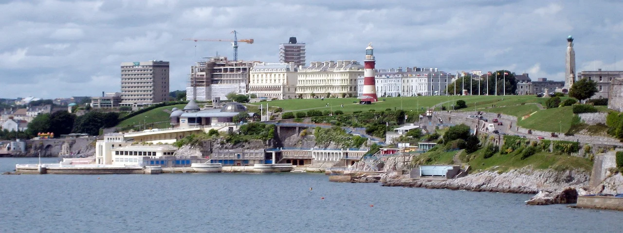
The tallest landmark on the Hoe is a lighthouse that does not light anything. Smeaton's Tower is the upper third of John Smeaton's Eddystone Lighthouse, built in 1759 on the Eddystone Rocks fourteen miles south in the open Channel. Smeaton's design revolutionised lighthouse construction: he used interlocking stones cut so that each course locked into the one below, and the whole tower curved upward like the trunk of an oak tree. It survived 120 years of Atlantic storms. By 1882 the rock beneath it was undermined and a replacement was built; the old lighthouse was carefully dismantled, hauled back to Plymouth, and rebuilt stone by stone on the Hoe in tribute to its designer. You can climb the spiral stairs inside, look out from the lantern room where the keepers once tended the oil lamps, and remember that this same view of Plymouth Sound was the view Smeaton's keepers never saw because they were always fourteen miles further out, alone on their rock.
The Royal Citadel
In the late 1660s, just after the Restoration of Charles II, the new king ordered the construction of a massive star-shaped stone fortress on the eastern end of the Hoe. It replaced an earlier Tudor fortress and was built to do two things. The first was straightforward: defend the port of Plymouth from any foreign fleet attempting to force the Sound. The second was less straightforward. During the Civil War, Plymouth had famously stood with Parliament against the King, and the Royal Citadel's guns pointed inland as well as out to sea. It was, in a polite sense, a reminder. The Citadel remains a working military installation more than three and a half centuries later, the longest-serving fortified position in Britain. Set into the citadel's southern fortifications is the Citadel Hill Laboratory of the Marine Biological Association, which since the 1880s has been one of the world's foremost institutions for the study of life in the sea.
The Memorials and the Tinside Lido
Along the northern edge of the Hoe stands the great Naval War Memorial, its central obelisk designed by Robert Lorimer and unveiled in 1924 to commemorate the Royal Navy dead of the First World War. Edward Maufe added the sunken garden of names in 1954, after the Second World War had added many more. Beside it stands the Armada Memorial, opened in 1888 to mark three hundred years since Drake's fleet sailed from this very water. A statue of Drake himself, sculpted by Joseph Boehm and a copy of the original in Drake's home town of Tavistock, was placed on the Hoe in 1884. Below the cliffs, the curved white concrete of Tinside Lido juts into the sea: a 1930s outdoor swimming pool built into the limestone foreshore, most of the works carried out to provide jobs for Plymouth's unemployed during the Depression. The lido still opens each summer, the same Art Deco crescent it has been for almost a century.
What Plymouth Looks At
From the cliff edge of the Hoe, on a clear day, you can see most of the city's reasons for existing. Plymouth Sound opens out below, the breakwater two miles offshore lying across its mouth like a punctuation mark. Drake's Island sits in the middle distance. The Hamoaze runs to the north, with Mount Edgcumbe rising on the Cornish side. The cross-Channel ferries to Roscoff and Santander come and go from Millbay. Royal Navy warships move in and out of Devonport. Yachts run before the wind, fishing trawlers thread the channels, and once a year in August the British Firework Championships fill the night sky over the Sound. The Hoe is where Plymouth comes to look at itself. It is also where Plymouth has always come to look outward, toward whatever might be approaching from the open sea: the Armada, the U-boats, the next storm, the next ship coming home.
From the Air
Plymouth Hoe sits at 50.364 degrees north, 4.142 degrees west, atop low limestone cliffs forming the seafront of central Plymouth, immediately south of the city centre and overlooking Plymouth Sound. From the air, the Hoe is unmistakable: a long green ridge running east-west, with the red-and-white striped Smeaton's Tower as the central landmark, the star-shaped Royal Citadel at its eastern end, and the Naval War Memorial obelisk to the west. Tinside Lido's curved white pool projects from the cliff face below. The Hoe commands views south across the Sound to the Breakwater and west across the Hamoaze to Mount Edgcumbe. Nearest controlled airport is Exeter (EGTE), 38 miles northeast; Newquay (EGHQ) is 40 miles west. Plymouth Sound has heavy maritime traffic and Devonport restricted airspace lies just to the north.
Nearby Stories
- Davidstow Circuit 3.7 km away
- Golden Hind 3.9 km away
- Powderham Castle 4.4 km away
- Fowey Lifeboat Station 5.1 km away
- Okehampton Castle 12 km away
- Battle of Plymouth (1652) 19 km away
- Goonhilly Satellite Earth Station 44 km away
- German Submarine U-672 73 km away