Poechos Reservoir
A billion cubic meters. That is what the engineers held back when they closed the Poechos Dam in 1976, and the scale was the point. Peru was in the middle of a military government that had nationalized the country's oil fields and promised its coastal farmers that the Piura valley would never again go thirsty. The Chira River, fed by Ecuadorian rains, would be tamed into irrigation canals stretching 42 kilometers south. The reservoir that rose behind the dam now holds enough water to irrigate 350 square kilometers of desert and generate electricity for a region that once went dark whenever the grid blinked. Seen from above, it is an improbable blue shape pressed against the border with Ecuador.
A Dictator's Dam
General Juan Velasco Alvarado seized power in 1968 and moved immediately against the International Petroleum Company, nationalizing the Talara refinery and creating Petroperu. Infrastructure followed ideology. If the revolution was going to redistribute the country's wealth, it needed to redistribute its water too. Construction on the Chira-Piura project began on June 24, 1972. Yugoslav contractor Energoprojekt built the main dam under supervision from the Peruvian subsidiary of British firm Binnie & Partners. Four years later, on June 4, 1976, the reservoir was inaugurated. The rock-filled Poechos dam stretched nine kilometers across the valley with a maximum height of 55 meters. The excavation required nine million cubic meters of earth and rock. It was, by any measure, a monumental piece of engineering for an agrarian reform that treated water as a public good.
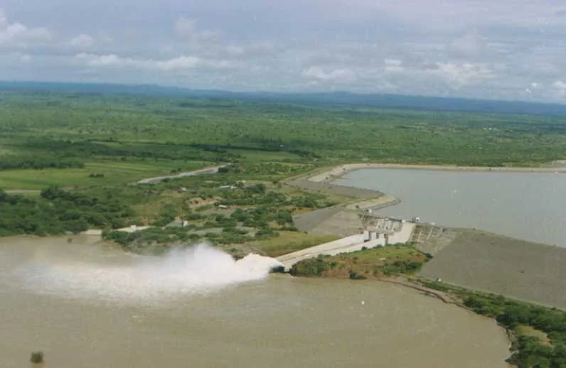
Four Phases of Concrete
The original dam was only the beginning. Phase one built the reservoir itself, the overflow structures capable of handling 10,000 cubic meters per second during floods, and a drainage channel in the lower Chira with more than 1,000 gates and outlets. Phase two, running from 1978 to 1985, added a 42-kilometer main canal and 60 kilometers of protective embankments along the Piura River, locking down a river system that had historically flooded unpredictably. Phase three, finished in 1997, extended irrigation canals north and south, covering another 220 square kilometers of farmland. The final phase, completed in 2004, brought in the 12.5-megawatt Curumuy plant and the 15.4-megawatt Poechos I hydroelectric station. The whole system sits at 98 meters above sea level, about 50 kilometers north of the city of Piura and 30 kilometers from the Ecuadorian border.
Desert, Remade
Before the dam, northern Peru's coastal valleys survived on whatever the Chira and Piura rivers chose to deliver. El Nino years brought catastrophic floods. La Nina years brought drought. Farmers planted cotton and rice on the strength of old almanacs and the hope that the rains would not betray them. After the dam, the calculation changed. The main irrigation canal carries 45 cubic meters per second. The Norte canal irrigates 150 square kilometers. The Sur canal, about 35 kilometers long, adds another 70 square kilometers. Suddenly the valley could support rice and sugarcane and mangoes and lemons on a commercial scale. The original brief had been to revitalize Piura, and on that narrow metric the project worked. Piura became one of Peru's most productive agricultural regions, and the city of the same name grew into a commercial hub for the north.
The Sediment Problem
Every reservoir ages. The Chira River carries sediment from the Andean foothills, and for five decades that sediment has been settling into the bottom of Poechos. The dam was designed for a billion cubic meters of useful capacity. Studies today suggest the reservoir has lost a significant fraction of that volume to silt, and each El Nino year, which brings extraordinary runoff, accelerates the problem. The Poechos I plant, operated by SINERSA, still generates about 60 gigawatt-hours per year for Electronoroeste, the regional utility. But engineers debate how long the reservoir can continue to function at full capacity, and whether a companion dam upstream might extend its life. Poechos was designed as a permanent answer to a seasonal problem. Time and sediment are proving that every answer is provisional.
From the Air
Located at 4.67 degrees south, 80.50 degrees west, in the Lancones district of Sullana province, just south of the Ecuadorian border. From altitude the reservoir appears as an irregular blue shape against the tan of the surrounding desert and the dark green of irrigated farmland to the south. Nearest airport is Capitan FAP Victor Montes Arias (SPLO) in Talara, about 70 kilometers west. Piura's Capitan FAP Guillermo Concha Iberico (SPUR) lies 80 kilometers south. Best visibility is during the dry season, May through November. The reservoir is clearly visible as a blue corridor winding through otherwise dry foothills.
Nearby Stories
- Tambogrande 1.5 km away
- Ayabaca province 9.2 km away
- Ignacio Escudero District 21 km away
- Los Organos 38 km away
- Cerros de Amotape National Park 40 km away
- Loja Province 41 km away
- Marañón Dry Forests 169 km away
- Easter Island: The Mystery of Rise and Collapse 3899 km away