
Pui O
In 1669, the Qing Emperor's coastal evacuation order was lifted. The Great Clearance — which had forcibly removed populations from China's southern coast to deny resources to Ming loyalist forces at sea — was over, and the villages along Lantau's shore could be resettled. Pui O was one of five Lantau communities repopulated that year. The others were Tung Sai Chung, Tai O, Shek Pik, and Mui Wo. The people who returned to Pui O had to rebuild from the ground up. They also had to contend with pirates.
Shaped by Bay and Mountain
Pui O is not simply a beach. It is a bay formed by the convergence of two geographic features: the Chi Ma Wan Peninsula, which curves around to the southwest, and the lower slopes of Sunset Peak, which press down from the east. Between them, a valley opens toward the South China Sea. A river drains that valley, and other smaller streams join it, all of them gathering in an estuary of wetland before reaching the coast. Where the estuary slows, the soil is rich with tidal silt. Pui O's villagers recognised this. They enclosed the wetland and converted it into rice paddies — a practical transformation of landscape that is recorded in the name of the hamlet Ham Tin, which reflects the character of that reclaimed ground. At the shore, the interplay of sea currents and river flow built a long beach, technically a spit — a finger of sand extending from the interaction of two water systems.
Walled Against Pirates
During the Qing dynasty, Lantau's coastal villages lived under persistent threat from pirates working the South China Sea. Pui O's four main villages — Lo Wai, San Wai, Lo Uk, and Ham Tin — were constructed as walled villages specifically to enable defence. The walls were practical engineering, not symbolic. A walled village in this tradition typically presented blank exterior walls to the outside, with only a single gate, making it difficult to breach quickly. Several Lantau villages, despite making their living from the sea, deliberately sited themselves at some distance from the shoreline for the same reason: proximity to the water increased exposure. This tension between livelihood and safety shaped the settlement patterns of the entire south Lantau coast. The walls have not all survived intact, but the four villages remain, and Lo Wai, San Wai, Lo Uk, and Ham Tin are all recognised under the New Territories Small House Policy.
29 Historic Buildings
The Antiquities and Monuments Office lists 29 historical buildings and features in Pui O — a density that reflects how much survived here when so much elsewhere in Hong Kong did not. The most significant is the Tin Hau Temple in Ham Tin, at Chung Hau. Tin Hau, the goddess of the sea, is the most widely worshipped deity along the South China coast, protector of fishermen and maritime communities. This particular temple was built during the Ming dynasty — the same era that ended with the Qing conquest and the Great Clearance. It was rebuilt in 1798, and repaired again in 1947, 1974, and 1995. The Cheung Ancestral Hall in Lo Wai, also known as Yue Tak Tong, was probably built in the late Qing dynasty. These structures are not museum pieces — they serve communities that have been on this land for centuries, maintained by people who have reasons to maintain them.
The Buffalo and the Wetland
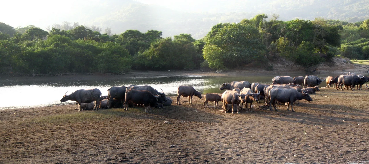
Water buffalo still graze at Pui O. They are descended from animals once used to work the rice paddies — ploughing the waterlogged fields, doing the heavy work of cultivation in conditions that would exhaust other animals. The paddies are gone now, the farming economy that required them long since transformed. But the buffalo remain, feral and free-ranging, moving through the estuary wetland and onto the beach. Pui O is one of the very few places in Hong Kong where this still happens. Mangrove grows on both sides of the estuary between Ham Tin and the beach — a transitional ecosystem between land and sea that provides habitat for a range of species. The water buffalo wade through it, unhurried. It is a sight that belongs to a different century — or perhaps to no particular century, just to a place that has kept something others have lost.
Trails and Routes In
The Lantau Trail passes through Pui O, threading this coastal community into the island's larger system of walking routes. Mountain bike tracks on the Chi Ma Wan Peninsula connect to a broader network. Pui O is on the South Lantau Road; buses on New Lantao Bus routes 1, 2, 3M, and 4 connect it to Mui Wo and other points. A branch road, Chi Ma Wan Road, cuts across the peninsula to Chi Ma Wan itself. The village is accessible, but not immediately so — which is part of what it has preserved. Visitors who arrive find a place that has been inhabited for a very long time, shaped by geography and history in ways that the landscape still carries.
From the Air
Pui O is located at approximately 22.240°N, 113.977°E on the south coast of Lantau Island. From 2,500 feet, the bay's distinctive shape is apparent: the Chi Ma Wan Peninsula curves around to the southwest, and the valley opening from Sunset Peak is visible to the east. The estuary wetland shows as a green-grey zone behind the beach. The four village clusters of Lo Wai, San Wai, Lo Uk, and Ham Tin can be distinguished from the air as distinct settlement patterns within the broader valley. Hong Kong International Airport (VHHH) lies approximately 16 nautical miles to the north-northwest. Lantau South Country Park occupies the high ground to the north and east. The South China Sea extends south with Cheung Chau Island visible to the southeast.
Nearby Stories
- Lok Ma Chau Loop 2.3 km away
- Portas do Cerco 2.3 km away
- Kweilin Incident 17 km away
- Wanshan Archipelago Campaign 34 km away
- Nanxiong Formation 115 km away
- Battle of Nanpeng Island 148 km away
- Heyuan 169 km away
- Cape Maobitou 632 km away