Rocas Atoll
At cruising altitude, Rocas Atoll is an almost-perfect oval drawn onto the Atlantic in white surf and turquoise water. From the International Space Station, where Expedition 22 photographed it in 2010, the ring shows up as a luminous eye staring back at orbit. From sea level, if you could reach it - and almost nobody can - it is a noise first: waves slamming into a coral rim, millions of seabirds arguing about real estate, nothing else. Rocas is the only atoll in the entire South Atlantic Ocean, 260 kilometers northeast of Natal and 145 kilometers west of Fernando de Noronha. There is no city here. There is barely any land. What there is, is geology being unusual enough to be singular.
The Shape of an Oddity
Most atolls live in the Pacific and Indian oceans, where volcanic seamounts and warm-water corals cooperate on a scale the Atlantic rarely permits. Rocas exists because a volcanic high rose close enough to the surface, long enough ago, for coral and red calcareous algae to build a rim around it and then for the volcano to slip back down. The ring is 3.7 kilometers long and 2.5 kilometers wide, the enclosed lagoon up to six meters deep and roughly 7.1 square kilometers in area. Two tiny islets break the surface inside the ring: Cemitério Island in the southwest, Farol Cay in the northwest. Together they add up to 0.36 square kilometers of dry land - less than the footprint of a midsized airport. The highest point on the whole atoll is a sand dune six meters tall. Weather matters here. So does luck.
Two Lighthouses, One Horizon
The Brazilian Navy keeps a working lighthouse at the northern end of Farol Cay, maintained continuously since the 1960s. A few hundred meters away, its predecessor still stands - a derelict 1933 tower that nobody had any reason to demolish. Together they make the atoll's only architecture: two slender verticals on an expanse of horizontal. The islets themselves are overgrown with coarse grass, scrubby bushes, and a scatter of palm trees. The non-avian residents are blunt: crabs, spiders, scorpions, sand fleas, beetles, and the kind of large roaches that suggest a long acquaintance with undisturbed ground. The birds, by contrast, arrive in clouds - noddies, boobies, and frigatebirds, all treating the place as a preferred node in their ocean lives.
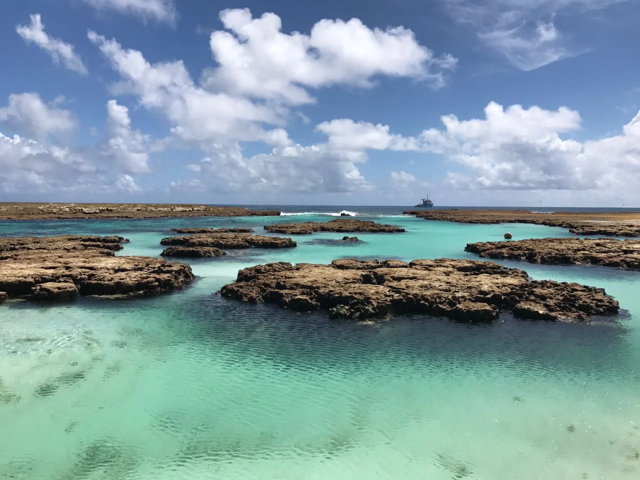
A Ring Nearly Closed
The coral ring around Rocas is almost sealed, but not quite. On the north side a 200-meter-wide channel cuts through the rim, and on the west a much narrower gap does the same. Twice a day the tide slams seawater through those openings, flushing the lagoon, recharging it with cooler Atlantic inputs. That exchange is what keeps the place alive as a nursery: reef fish spawn inside the calm lagoon; sharks, turtles, and dolphins move through the channels to feed. The mineralogy is unusual too. The "rocks" in Rocas are mostly not rock in the igneous sense; they are cemented carbonate built by coral and by coralline red algae, the latter thriving here at a surprisingly high latitude. The whole formation is sometimes called an algal-coral atoll for that reason.
Remoteness as Policy
UNESCO inscribed Rocas as a World Heritage Site in 2001, recognizing it as a critical feeding ground for marine life in a stretch of ocean that does not have many such places. The atoll and the waters around it sit inside the Atol das Rocas Biological Reserve, the most restrictive conservation category Brazil offers, and are now closed to tourism. Only researchers with permits set foot on Farol Cay. The remoteness that saved the atoll has also limited it: few scientific studies have been done here, and even the invertebrate fauna is still being catalogued. That is the strange bargain of the place. Rocas is undisturbed because it is hard to reach, and we know comparatively little about it because it is undisturbed. From altitude, all of this reads as a single bright oval, a punctuation mark in the South Atlantic, easy to miss unless you are looking for it.
From the Air
Rocas Atoll at 3.87°S, 33.80°W, roughly 260 km northeast of Natal, Rio Grande do Norte, and 145 km west of Fernando de Noronha. From 8,000-12,000 feet the oval coral ring - 3.7 km long, 2.5 km wide - is unmistakable against open ocean; look for the two islets (Cemitério southwest, Farol Cay northwest) and the narrow surf line marking the almost-closed rim. Nearest runway is on Fernando de Noronha (SBFN) eastward; Natal's Greater Airport (SBSG) lies on the mainland coast to the southwest. No airstrip on the atoll itself. Trade-wind clouds and ocean haze can obscure the feature in the wetter January-June months.
Nearby Stories
- Touros 170 km away
- 1986 João Câmara earthquake 242 km away
- Açu, Rio Grande do Norte 372 km away
- Guajiru 532 km away
- Emboaca 599 km away
- Nadir Crater 2309 km away
- Orango National Park 2536 km away
- Loango Slavery Harbour 5013 km away