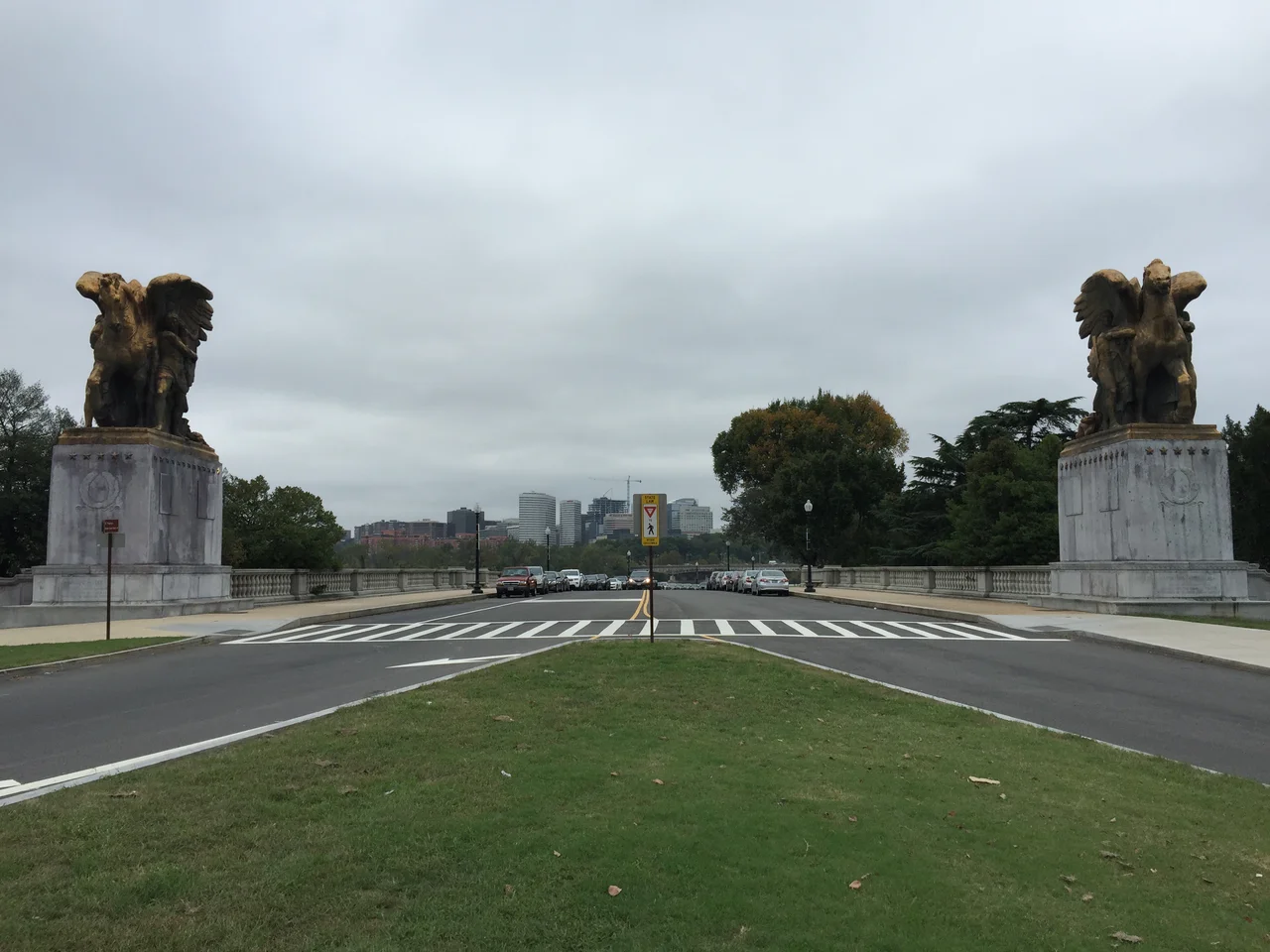

Rock Creek and Potomac Parkway
Every weekday at 6:45 in the morning, four or five United States Park Police officers throttle up their motorcycles, drop into traffic on the Rock Creek and Potomac Parkway, and start placing barricades. By 9:30 a.m., the entire four-lane road has been reversed - what was northbound is southbound, what was southbound is closed. In the afternoon, between 3:45 and 6:30 p.m., they do it again in the other direction. The changeover takes thirty minutes from end to end, which means the parkway functions as a one-way commuter chute for only about two real hours each rush. The rest of the time it does what it was designed to do in 1923: carry cars slowly through a wooded river valley, framed by sculpture, parallel to a creek the rest of Washington forgot.
A Parkway, Not a Highway
The distinction matters. The Rock Creek and Potomac Parkway, built between 1923 and 1936, was conceived in the era when Americans believed roads could be works of landscape art - winding, scenic, hostile to commerce. Trucks have never been allowed. Stone-faced bridges arch the creek; mature trees press against the shoulders; the road never moves in a straight line for long. The National Register of Historic Places added it in 2005, calling it one of the best-preserved examples of the earliest stage of motor parkway development. It runs from the traffic circle around the Lincoln Memorial up to Beach Drive near Calvert Street, just south of the National Zoo, threading a path along the Potomac and then up Rock Creek through some of the wealthiest residential neighborhoods in the city. The southern entrance is flanked by The Arts of Peace, two gilded equestrian groups by James Earle Fraser titled Music and Harvest and Aspiration and Literature. Both were erected in 1951.
The Daily Reversal
Reversible-lane highways exist elsewhere in America. Reversible roadways - the entire road flipping direction - are nearly extinct. Drivers entering during a changeover sometimes find themselves alone on four empty lanes wondering whether they have made a serious mistake. After the District eliminated its peak-hour reversible setup on Connecticut Avenue in 2020, the National Park Service began studying whether the parkway should follow. A 2024 Department of Transportation study found that crashes spike disproportionately during the one-way windows, blaming heavy traffic, the parkway's narrow nineteenth-century geometry, and signage that confuses unfamiliar drivers. The Park Service opened public scoping for an environmental assessment in the winter of 2024-25. The motorcycles, for now, still roll out twice a day.
Landmarks at Speed
Even at thirty-five miles an hour the parkway delivers an extraordinary roll call of monuments. The southern entrance passes the Lincoln Memorial and the Arlington Memorial Bridge. The Kennedy Center for the Performing Arts looms next, an at-grade intersection at F Street separating it from the road. Just past F, the Watergate complex - the Saarinen-curved hotel-apartment-office complex whose name became shorthand for political scandal - sits at the river bend. Beyond Virginia Avenue the parkway slips inland and follows Rock Creek itself, ducking under Pennsylvania Avenue, M Street, P Street, the Dumbarton Bridge, the Charles C. Glover Bridge carrying Massachusetts Avenue, and finally the William H. Taft and Duke Ellington Bridges at Connecticut Avenue. Some of these bridges are notable on their own merit; the Taft Bridge, completed in 1907, is one of the largest unreinforced concrete structures ever built.
The Trail Alongside
Where the parkway carries cars, a paved trail carries everyone else. The Rock Creek Park Trail runs the full length, from the Lincoln Memorial to Connecticut Avenue, and continues north along Beach Drive. The Shoreline section along the Potomac, the oldest piece, predates 1967. The middle stretch has a stranger origin. In 1971, the Park Service shut down a lane of the parkway north of Virginia Avenue for a week to see if Washingtonians would try commuting by bicycle. They did - so enthusiastically that the experiment created traffic jams. Rather than keep the lane, the Park Service paved the bridle paths that had run alongside the creek since the park's founding, extending the trail to Calvert Street in September 1971 and another two miles to Bluff Bridge in 1972. In 1981 a separate cyclist bridge appeared next to the rebuilt L Street bridge. By 1997 the Shoreline section had been repaved and realigned. The cyclists came first and the city followed.
The Hidden Valley
From the air, the parkway and creek together carve a wooded green stripe right through the densely built capital - a vein of forest that runs from the Potomac up past the National Zoo and continues into Maryland. The contrast is the point. On either side stand embassies, the Naval Observatory, Georgetown, Adams Morgan, Kalorama. Between them lies a roughly half-mile-wide canyon of oaks and creekside boulders, kept wild because Congress in 1890 set aside Rock Creek Park as one of the first federally protected urban parks in the country. Driving the parkway, you see almost none of the surrounding city. You see stone bridges, water, light filtering through hardwoods - and, twice a day, a motorcade of Park Police executing one of the strangest commuting choreographies in America.
From the Air
The Rock Creek and Potomac Parkway runs from about 38.8889 degrees N, 77.0500 degrees W at the Lincoln Memorial north to roughly 38.9214 degrees N, 77.0500 degrees W near the National Zoo, threading the wooded valley of Rock Creek and the western shore of the Potomac. From the air the corridor reads as a continuous green ribbon through dense Washington urbanity, broken only by the stone-arched bridges (Taft, Duke Ellington, Glover, Dumbarton) crossing over the canyon. Best viewed at 1,500 to 2,500 feet AGL; the FRZ around Washington restricts general aviation, and the prohibited area P-56A covers the Mall just east. Nearest airports are Ronald Reagan Washington National (KDCA) 3 nm south, College Park (KCGS) 6 nm northeast, and Washington Dulles (KIAD) 22 nm west.
Nearby Stories
- Gunston Hall 1.1 km away
- 2023 Baltimore Shooting 4.9 km away
- Battle of Middleburg 6.6 km away
- Crownsville Hospital Center 10 km away
- Battle of Loudoun Heights 13 km away
- First Battle of Rappahannock Station 20 km away
- Howard County, Maryland 21 km away
- Harriet Tubman Underground Railroad 50 km away