_viewing_south_west_from_north_east,_August_2020.jpg)
Rough Tor
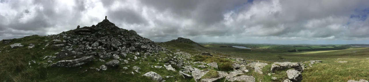
Locals once called it Router, and into the late twentieth century some still did. Then the spelling tightened on the maps and the older sound thinned out, but the hill itself has barely flinched. Rough Tor rises 1,313 feet above the wind-flattened heath of Bodmin Moor, its granite crown bristling with weathered outcrops that look, from a distance, like the spine of something half-buried. A mile to the south-east stands Brown Willy, Cornwall's highest point. Between them, the De Lank River wakes up from a moorland source and starts its run to the sea. Walk the path from the car park at Roughtor Ford and you climb into a landscape that has been continuously occupied, contested, and remembered for five thousand years.
A Crown Built by Hand
The summit is not simply rock. It is rock and intention, layered. Sometime in the Neolithic, people climbed this hill and began building a tor enclosure - rough stone walls woven between the natural outcrops, originally ringing the entire crown with stone-lined openings. Inside that ring, archaeologists have traced terraces cut into the slope, foundations for circular wooden houses, and cleared patches that may have been small garden plots. To stand among those tumbled walls now is to share a footprint with a community that chose this exposed height deliberately. They lived here. They farmed here. They watched the weather come in from the Atlantic just as visitors do today, only with far more at stake.
The Bronze Age Neighbourhood
By the Bronze Age, the moorland around Rough Tor had become something close to a small city of stone. On the southern slopes, the remains of dozens of hut circles still huddle in clusters, grouped around three or four larger enclosures that probably held livestock. A field system fans out across the slope, partially overwritten by medieval boundaries that came thousands of years later. Two hundred metres from the tor stands Fernacre stone circle. A little further off, the more famous Stannon circle traces another ring on the gentle slope of Dinnever Hill. Cairns and burial monuments dot the surrounding ground. This was not a remote outpost. It was a centre.
St Michael on the Summit
Long after the Bronze Age communities had drifted away, the summit was sanctified again. A medieval chapel was built into the side of one of the cairns at the top of the tor, dedicated to St Michael and recorded in the fourteenth century. It is the only known hilltop chapel on Bodmin Moor. From the summit, an ancient trackway across the moor was clearly visible below, and historians suspect the chapel served travellers as both shrine and waymark - a small flame of stone and prayer at the highest point a moor-walker would see for miles. There are remains of a second medieval building at the foot of the summit, and a hermit may have tended a beacon nearby. The chapel is long ruined, its dedication outlasting its walls.
Wrestlers, Tourists, and Du Maurier
In the 1800s, Cornish wrestling tournaments were held on the slopes of Rough Tor as part of larger moorland festivals - prize bouts on the granite turf, audiences spread out across the heath. By 1927, a Ward Lock travel guide was recommending the tor to visitors, calling its scenery "wildly grand, rugged and bleak" and suggesting they hire a vehicle in Camelford for the trip. A decade later, Daphne du Maurier wove the tor into Jamaica Inn, her 1936 novel of smugglers and moorland menace - the bleakness rebranded as gothic atmosphere. Even Tasmania carries a faint echo. Matthew Flinders, charting the colony's north, named a mountain Row Tor in apparent reference to this Cornish summit; the spelling eventually shifted, but the homonym remains.
Three Tors, One Ridge
What walkers usually call Rough Tor is really three. Showery Tor sits to the north, sometimes nicknamed Flat Cap Ned for its distinctive capstone. Little Rough Tor stands between, and Rough Tor proper crowns the southern end of the ridge. A logan stone - a massive boulder balanced so that it rocks in the wind - sits among the summit outcrops, the kind of geological accident that Neolithic builders likely treated as sacred. The path from the car park is gentle for a Cornish hill, about a mile and a half each way, but the wind off the moor is rarely gentle with it. You climb past the war memorial to the 43rd Wessex Division, past the cleared platforms of vanished Bronze Age homes, into a sky that on a clear day shows you the whole of Bodmin Moor folding south toward the coast.
From the Air
Located at 50.596°N, 4.624°W on Bodmin Moor in north Cornwall. Summit elevation 400 m (1,313 ft). Recommended viewing altitude 2,500-4,000 ft AGL to take in the broader moor and the twin ridge with Brown Willy a mile to the south-east. Visual landmarks: Crowdy Reservoir sits 1.5 nm north-east; the A39 follows the coast 6 nm to the west; the small town of Camelford lies 3 nm north-west. Nearest civilian airports: Newquay (EGHQ) 22 nm south-west, Exeter (EGTE) 56 nm east. Watch for sudden weather closures - Bodmin Moor generates its own cloud layer and visibility can drop quickly even on sunny days.
Nearby Stories
- Gunnislake 1.5 km away
- Tehidy Country Park 4.2 km away
- Caerhays Castle 8.1 km away
- Bude 15 km away
- Hope Cove Lifeboat Station 26 km away
- Appledore Lifeboat Station 29 km away
- Godrevy Lighthouse 34 km away
- Action of 17 November 1917 82 km away