Santo Antônio do Rio Abaixo
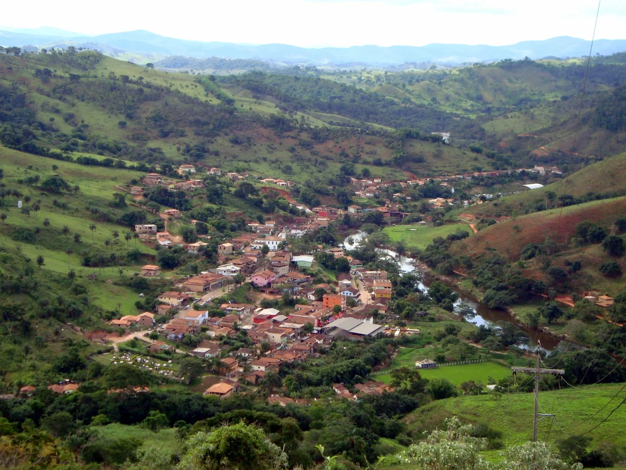
Manuel de Borba Gato found gold at Sabará in 1695 - the discovery that would detonate the entire Minas Gerais gold rush - and he kept moving. He followed the Santo Antônio River north to the town of Ferros, then pushed further. Portuguese prospectors from the Duarte and Alvarenga families found the same river's alluvial shelves heavy with gold dust, and they built their wattle-and-daub huts on the right bank. They named the place for its patron saint and for the direction the water carried them: Santo Antônio do Rio Abaixo - St. Anthony of the River Below. The river gave them their living. The river named their town. Three centuries later, the river is still here, still running over the rocks with the white rapids that now draw swimmers instead of gold panners, and the town still holds 1,760 people who live along its banks.
A Queen's Permission
By 1787, the settlement had grown to about 400 people clustered along the Santo Antônio. That year, a man named José Ferreira Santiago wrote to Queen Maria I of Portugal requesting permission to build a chapel for himself and his neighbors. The queen - who was famously pious, eventually suffering a breakdown attributed partly to her religious obsessions - granted the request on 10 March 1788. Chapel construction began. This is how colonial Brazil worked: a village of gold miners in the deep interior wrote a letter across the Atlantic, waited months for an answer, and only then broke ground. The queen's stamp of approval was required for sacred buildings, sanctifying what would otherwise be a mere shed in the woods. Rio Abaixo's first chapel went up under royal sanction, and the village acquired the status of a place on the map.
From District to Municipality
For almost two hundred years, Santo Antônio do Rio Abaixo was part of something larger. On 4 January 1875, it was formally made a district of Conceição do Mato Dentro, the nearest town of consequence. Life in a district is different from life in a municipality - no mayor, no council, no right to set local ordinances. Residents had to go elsewhere to have things decided for them. Political emancipation came slowly. The state government created the municipality on 30 December 1962, and it was installed on 1 March 1963. On 30 June of that year, the first elections were held for mayor, deputy mayor, and city council. The winners were sworn in on 3 September 1963, more than 250 years after the first Portuguese huts went up by the river. For the first time, Santo Antônio do Rio Abaixo governed itself.
A Town Losing Its Old Buildings
The colonial architecture of Rio Abaixo was never monumental. There were a few colonial-style houses, a parish house, a mill at the entrance of the town, the old church, and the mansions of surrounding farms. Since the 1980s, the town has lost much of this. The mill at the entrance is gone. The parish house beside the church - perhaps the oldest building in town - has been demolished. What remains are a handful of farmhouses in the countryside around the urban center, and the church itself, which still anchors the view from the rapids. Small towns lose their pasts in ways that big cities rarely do. There are no protected districts, no preservation funds, no tourists arriving in numbers sufficient to make historical buildings pay for themselves. The old wood rots. The new brick goes up. The place remembers less than it once did.
The River, the Falls, the Peak
Mount Cristal rises to 897 meters above the town - not a dramatic peak by Brazilian standards, but it dominates the local skyline and marks the upper reach of the municipality's terrain. Below the mountain, the Santo Antônio River runs over rapids that are the town's main draw. Within municipal limits, the Peixe River adds its own cascades and waterfalls, some of them destination-worthy: the Cristal Falls, Chuvisco Falls, Bahia Falls, Angico Falls, Martins Leite Falls, Limão Falls, Ribeirão Falls, and Domingo Falls. Natural pools gather where water breaks over stone. Fluvial beaches at Tabuleiro and Vieiras offer sandy stretches along the river. The town is 190 kilometers from Belo Horizonte by MG-010, BR-381, and BR-120 - far enough to be unreachable as a casual day trip, close enough for weekenders escaping the city heat.
What Is Not Treated
The Wikipedia article on Santo Antônio do Rio Abaixo includes a sentence many Brazilian tourism pages omit: the wastewater produced by the city is not treated and is discharged raw into the Santo Antônio River. This is the municipal reality beneath the picturesque surface. A town of 1,760 people with no sewage treatment plant, discharging directly into the same river whose rapids draw its visitors. The sentence sits in the article as a piece of civic honesty. Rural Brazil is full of such places - too small to justify infrastructure investments, too poor to self-finance, caught in the gap between the grandeur of the waterfalls and the unfunded reality of how a community handles its waste. The river does what rivers do. It keeps moving. It carries what is given to it downstream, toward the Doce.
From the Air
Coordinates 19.23°S, 43.25°W place Santo Antônio do Rio Abaixo 190 km north of Belo Horizonte via MG-010, BR-381, and BR-120. Recommended viewing altitude 3,500-5,000 feet AGL. Mount Cristal (897 m) is visible to the north. The town sits in the Doce River basin. Nearest airport is Tancredo Neves International (SBCF) at Belo Horizonte, 190 km south. Usiminas Airport (SBIP) at Ipatinga is roughly 150 km east. Waterfalls on the Peixe River are visible from low altitude in clear weather.
Nearby Stories
- Sumidouro State Park 4.1 km away
- Morro Velho 13 km away
- Coronel Fabriciano 27 km away
- Serra dos Cocais 32 km away
- Paraopeba 48 km away
- Minas Gerais 66 km away
- Pico do Itambé State Park 66 km away
- Vila Império 97 km away