Coronel Fabriciano
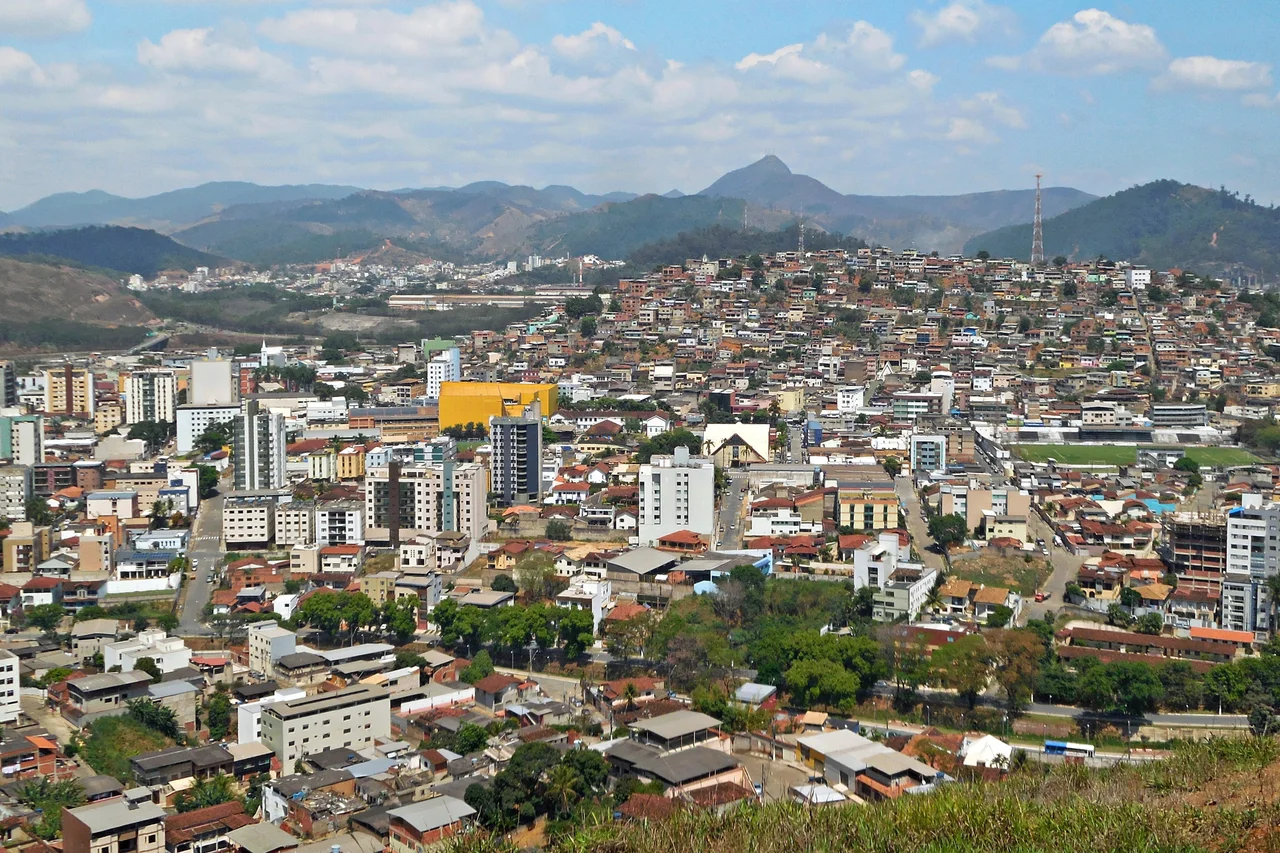
Here is an unusual civic achievement: Coronel Fabriciano founded itself in 1948, grew fast enough to need two steel mills, and then watched those mills walk out the door. The neighboring districts that hosted them - Ipatinga and Timoteo - broke off in 1964 as independent municipalities, taking the furnaces and the tax base with them. Fabriciano became the middle town of the Vale do Aco, the Steel Valley, squeezed between two successful offspring. What it kept was the hills: the Serra dos Cocais rising out of the eastern suburbs, with waterfalls and rock outcrops the bigger steel cities cannot match.
First Named for a Stream, Then a Colonel
The original name of the place, when it was still forest, was Barra - for the confluence of the Caladao Stream with a larger river. When the railroad arrived and a small station opened, the settlement began calling itself Calado, meaning Quiet. It got renamed briefly after a politician named Raul Soares, then reverted to Calado. In August 1938 it took on the present name in honor of Lieutenant Colonel Fabriciano Felisberto Carvalho de Brito, on the centennial of his birth. The first proper house with ceramic tiles and a finished floor was built in 1928 - everything else before then had been rough railroad shacks. It was still that primitive only a century ago.
The Steel Came, and Kept Going
Brazil industrialized fast in the mid-20th century, and Minas Gerais built the mills. Usiminas - one of the giants - was constructed in territory that was then part of Fabriciano. Acesita, later known as Aperam South America, was built in what was also then Fabriciano. The mills attracted workers, the town grew, and by 1964 both industrial neighborhoods had enough population and political clout to break away and become cities in their own right. Ipatinga, home of Usiminas, is now larger than its parent. Timoteo, home of Aperam, is a few kilometers south. Fabriciano got the administrative bones of the original municipality but not the industrial revenues. It is the donor parent of one of the most important steel regions in South America.
Serra dos Cocais
The mountains the city kept are worth flying over. The Serra dos Cocais rises sharply to the east of town, a chain of granite outcrops with the evocative names Brazilian rural geography specializes in: Pedra Dois Irmaos, the Two Brothers; Pedra do Caladao, Silent Stone; the Cachoeira do Escorregador, which translates roughly as Slide Waterfall - a broad sheet of rock over which a stream slides rather than falls. The Trilhas da Mamucha are a network of trails that weave among the rocks. The city's Jeep Club has turned the ridges into a regional hub for four-by-four rallies, and in 2008 Fabriciano hosted a round of the state's 4x4 Regularity Championship. Parachute jumping, mountain biking, and trekking round out the list.
Eucalyptus Economy
Without the steel mills, Fabriciano's economy tilts toward trade, services, and a particular form of agriculture that transformed the countryside: eucalyptus monoculture. The fast-growing Australian trees cover thousands of hectares around the city, harvested on short rotations for Cenibra - a Brazilian-Japanese cellulose factory in nearby Belo Oriente - and for local charcoal kilns. Eucalyptus plantations are controversial in Brazil. They grow fast, they sequester carbon, and they also drink groundwater faster than native forests and support far less biodiversity. The regulation and ecology of these plantations is an ongoing policy debate across Minas Gerais. The trees are what you will see from the air across much of the landscape.
A Mid-Sized City With a Saint
Coronel Fabriciano had about 110,000 residents as of a 2020 estimate by IBGE, Brazil's census agency, and a Human Development Index of 0.755 - classified as high by the UN. It is the second-largest city in the Vale do Aco metropolitan area, with the third-largest GDP. The patron saint is Sao Sebastiao, martyred around 288 AD, and the city celebrates its official birthday on January 20, his feast day, rather than on the December 27, 1948 date when the Legislative Assembly of Minas Gerais actually created the municipality. The Saint Sebastian Parish Church dates from 1949, the year after emancipation. These are the landmarks of a working Brazilian city: mid-sized, mid-latitude, mid-altitude at 240 meters, with a sub-tropical climate averaging 22 degrees Celsius and enough steel history to matter, even if most of it now lives next door.
From the Air
Located at 19.52 degrees S, 42.63 degrees W on the Piracicaba River in the Vale do Rio Doce of Minas Gerais. Best viewed from 4,000 to 6,000 feet AGL to appreciate the contrast between the urban core, the neighboring Usiminas and Aperam steel works in Ipatinga and Timoteo (directly adjacent), and the Serra dos Cocais rising to the east. At 240 meters elevation, the terrain is rolling. Nearest airport is Usiminas Airport in Ipatinga (SBIP), about 8 nm east; Belo Horizonte/Confins (SBCF) is 105 nm west. In the approach, look for the dark blocks of eucalyptus plantations contrasting with surviving patches of Atlantic Forest.
Nearby Stories
- Santo Antônio do Rio Abaixo 12 km away
- Santa Bárbara, Minas Gerais 21 km away
- Morro Velho 28 km away
- Feliciano Miguel Abdala Private Natural Heritage Reserve 41 km away
- Vila Império 55 km away
- Robert Quayle (1814 ship) 73 km away
- Governador Valadares, Minas Gerais 97 km away
- Pedra Azul State Park 136 km away