Scharhörnbake
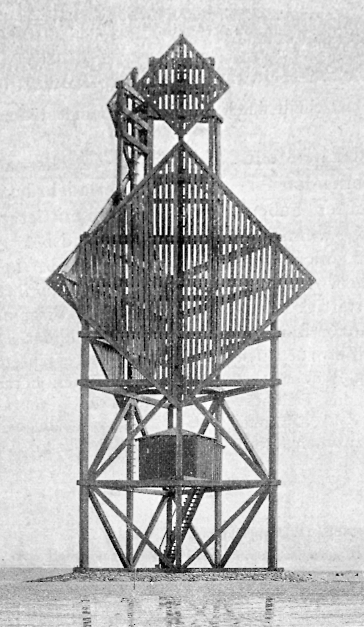
It was not a lighthouse. It carried no flame, no lamp, no light at all. The Scharhörnbake was a daymark - a structure tall enough and distinctive enough to be seen by a captain in daylight against the unbroken grey of the German Bight - and for three centuries and eighteen years it was the most important one on the German North Sea coast. The City of Hamburg first erected it in 1661 on a sandbank called Scharhörn, on the south side of the Elbe estuary. Storms knocked it down. Wars required it taken down. Each time, Hamburg rebuilt it. By the late nineteenth century, in its final and strangest form, the Scharhörnbake looked like two great wooden diamonds stacked on top of each other, rising to 29.1 meters above the sand. It was the tallest daymark on the entire coast.
Why Hamburg Cared
The story of Scharhörnbake is, before anything else, a story about Hamburg's commerce. Trade ships approaching the Elbe from the open North Sea had to thread between the Scharhörn Reef and the surrounding sandbanks, then run upriver past the Vogelsand to reach the port. Many did not make it. Hamburg had been maintaining marks around the reefs since 1440 - more than two centuries before the Scharhörnbake itself was first built. The system worked by lines of bearing. A captain coming in from the sea would look first for the Rothe Ton, a buoy off his starboard. Beyond it, he had to line up the Scharhörnbake with the older Great Tower Neuwerk - a medieval sea tower already standing on the nearby island - and steam straight along that bearing. Holding the two structures in alignment meant he was in the safe channel. Drifting off it meant rocks.
Three Bearings
There were three of these alignments, each painstakingly maintained. Holding the Scharhörnbake on the Great Tower Neuwerk delivered the captain into the approach. Holding the Nordbake to obscure the small Blüse Neuwerk lighthouse pointed him toward Scharton, the channel before the Vogelsand sandbank. Holding the Werkbalger Bake pointed him toward Butterton, the channel afterward. Each navigation aid had to be built large, kept maintained, repaired after every winter storm. The Great Tower Neuwerk was Hamburg's oldest sea tower - it already existed; the Scharhörnbake was the tallest. The cost and effort of maintaining both for centuries says something hard to overstate about the importance of the Elbe to the medieval and early modern city. Hamburg's wealth was the river's mouth, and the river's mouth was Scharhörn.
A Room for the Shipwrecked
Around 1840, Hamburg added something unusual to the daymark: a small room. The Scharhörnbake became a refuge beacon. If your ship broke up on the reef and you could swim or wade to the sandbank, you could climb inside the tower and find emergency provisions, refreshed routinely by the city, waiting for the next patrol boat or rescue crew. From 1840 until 1965, that room was kept stocked. How many lives it saved is not recorded. By the 1920s, plantings of marram grass and other dune stabilizers had transformed the sandbank Scharhörn into an actual permanent island, and shacks began appearing on it starting in 1929. The refuge function gradually became obsolete; the shacks could do the job. But the room remained, a strange small interior in the wooden lattice of a navigation aid, in case a sailor still needed it.
What Remains
The end came in 1979, after 318 years. Storms had taken it down many times; wars - the form and position varied with each reconstruction because Hamburg sometimes removed it to confuse enemy ships - had taken it down deliberately. By the late twentieth century the channel system had been remade with modern lighthouses, electronic radar, GPS waypoints, none of which required a tall wooden tower planted on a sandbank. The Scharhörnbake came down for the last time. What is left today is the boulder stone foundation near Nigehörn, the small younger sand island just west of Scharhörn. The two diamonds stacked on a wooden frame, the tallest daymark on the coast for sixteen years between 1898 and 1914, exist now in old maps and in two illustrations from a 1721 Elbe chart - the kind of artifacts that survive when the structure itself is finally gone.
From the Air
The site of the former Scharhörnbake lies at 53.95°N, 8.41°E on the sandbank Scharhörn, just south of the Elbe estuary in the German Bight. Today only the boulder foundation remains, near the small adjacent sand island of Nigehörn. The nearest landmark is the island of Neuwerk to the northeast, with its medieval Great Tower (Großer Turm Neuwerk) still standing - a useful navigational reference both historically and visually from the air. The nearest aviation reference is Nordholz/Cuxhaven (ETMN) to the south. The whole area is within the Hamburg Wadden Sea National Park; overflights must respect the strict bird sanctuary protections. Recommended viewing altitude 1,500-2,500 feet for the sand island chain, the Elbe approach channels, and Neuwerk with its surviving great tower.
Nearby Stories
- German Trawler V 1101 Preussen 6.6 km away
- JadeWeserPort 8.4 km away
- Taktisches Luftwaffengeschwader 71 "Richthofen" 8.5 km away
- SM UC-45 9.9 km away
- HMS Ariel (1911) 13 km away
- Wöbbelin Concentration Camp 181 km away
- Ludwigslust Palace 188 km away
- Lilleø 194 km away