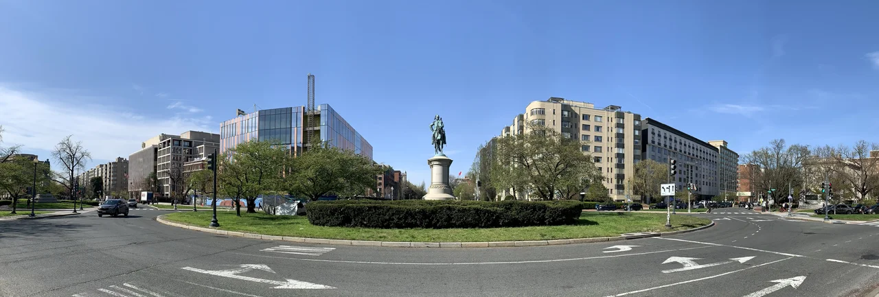

Scott Circle
Scott Circle is not, and has never been, a circle. On Pierre L'Enfant's 1791 plan it was a rectangle. The Ellicott revision made it a bigger rectangle. By the late 1870s the city had started calling it a circle anyway - Scott Square became Scott Circle without anyone bothering to make the geometry honest - and the shape on the ground today is a bow tie of pavement straddling the intersection of Massachusetts Avenue, Rhode Island Avenue, and 16th Street NW. The central ellipse, ringed by an actual roundabout, has been pedestrian-impossible to reach since 1941, when a tunnel for 16th Street was dug straight through underneath. The general it is named for, Winfield Scott, sits on a bronze horse in the middle of the inaccessible ellipse, facing south down 16th Street toward the White House he once expected to occupy.
Jamaica
Before Scott, the patch of ground at the high end of Sixteenth Street was called Jamaica. Nobody quite knows why. A small stream called Slash Run cut through it, a tributary of Rock Creek that drained the slopes between Dupont Circle and Logan Circle before disappearing into the Potomac. When the federal city began annexing this area in the 1860s and 1870s, Slash Run was buried in a sewer line along with the water and gas mains, and the rectangle that had been Jamaica was redeveloped as an upscale residential square. Massachusetts Avenue got concrete paving; Rhode Island Avenue and 16th Street got wooden blocks. The neighborhood quickly filled with the brick and brownstone rowhouses of the Gilded Age, and the central park was envisioned as a recreation ground for the families along the edges.
Why It Is Called Scott
Winfield Scott was the most decorated American general between Washington and Grant - he commanded U.S. forces in the Mexican War, devised the Anaconda Plan that ultimately won the Civil War for the Union, and ran unsuccessfully for president in 1852. Henry Kirke Brown sculpted his fifteen-foot bronze equestrian statue, originally intended for what is now McPherson Square. Congress changed its mind and in 1872 ordered the statue moved to the Massachusetts-Rhode Island intersection, where it was erected in 1874. The square took its name from the statue. From his bronze saddle Scott looks straight south down 16th Street to Lafayette Square and the White House - exactly the sight line that would, sixty-seven years later, dictate which avenue got the underpass.
The 16th Street Underpass
By 1940, when the city completed an underpass at Thomas Circle just to the south, Scott Circle had become 'one of the worst remaining traffic bottlenecks in the city.' The square's residents had largely moved out and been replaced by embassies, professional associations, and apartment buildings - the AAAS, the National Democratic Club in the old Bell House, the Peruvian Embassy in the William Windom House, the General Scott Apartments where the Pendleton and Cameron mansions had stood. More traffic, less neighborhood. The 1941 plan to dig a tunnel under the circle triggered a small civic war between two camps of lobbyists. Frank B. Steele led residents along 16th Street, arguing the tunnel should follow Massachusetts Avenue and spare their property values and street trees. F. Scott Avery led the Massachusetts Avenue camp, who produced old records showing Slash Run still ran beneath the avenue's pavement and drilling results showing weaker foundation soil. The National Capital Park and Planning Commission, with Interior Secretary Harold Ickes weighing in, sided with the Massachusetts Avenue lobby. Construction began February 3, 1941. The Cayuga Construction Company moved the Scott statue intact - bronze still attached to its granite base - and then put it back when the tunnel was finished on December 29, 1941. There was no opening ceremony. The District commissioners had planned to lead the first traffic through, but their car was beaten by several other cars, a truck, and a bus.
The Bow Tie
The shape that resulted is not what anyone would draw on a planning map today. The central ellipse, holding Scott on his horse, is surrounded on all sides by traffic and has no pedestrian crossings. To its east, a triangle of land between Massachusetts Avenue and Rhode Island Avenue holds the Daniel Webster Memorial, designed by Gaetano Trentanove and dedicated in 1900. To its west, a matching triangle holds the Samuel Hahnemann Monument, dedicated in 1900 to the German physician who founded homeopathy. The two side triangles plus the central ellipse form a horizontal bow tie. Corregidor and Bataan Streets - named after the World War II battles - border the wings. The Webster triangle is mainly hedges. The Hahnemann triangle has benches, mature trees, and the only seating in the entire complex. The original idea of a neighborhood recreation ground died with the residential neighborhood it was built to serve.
Embassy Row Begins Here
Scott Circle marks the eastern start of Embassy Row, the stretch of Massachusetts Avenue running northwest toward the Naval Observatory that became the diplomatic spine of Washington in the mid-twentieth century. The Peruvian Embassy that occupied the Windom House was torn down in 1964 to make room for the original Australian Embassy, which opened in 1969 and was itself demolished in 2020 for a larger replacement. The Embassy of the Philippines was built nearby in 1993, and the Embassy of Tunisia took over the AAAS headquarters. Three hotels - the Marriott Courtyard, Wyndham, and Governor's Inn - filled in around them. The National Education Association replaced the Williams and Guggenheim mansions and the demolished Hotel Martinique in 1968. What had been one of the most desirable residential addresses in the District by 1900 was, by 2000, almost entirely a working diplomatic and institutional quarter - the kind of place visitors arrive in by Town Car and leave the same way.
From the Air
Scott Circle sits at 38.9072 degrees N, 77.0365 degrees W, at the intersection of Massachusetts Avenue, Rhode Island Avenue, and 16th Street NW, about eight blocks due north of the White House. From the air the bow-tie shape and the bronze equestrian statue at its center are obvious, framed by the modernist mid-rise office buildings of the surrounding embassies and institutional headquarters. Best viewed at 1,500 to 2,500 feet AGL; the entire site lies within the Washington FRZ and the prohibited area P-56A. Nearest airports are Ronald Reagan Washington National (KDCA) 3 nm south, College Park (KCGS) 7 nm northeast, and Washington Dulles (KIAD) 23 nm west.
Nearby Stories
- Gunston Hall 1.1 km away
- 2023 Baltimore Shooting 4.9 km away
- Battle of Middleburg 6.6 km away
- Crownsville Hospital Center 10 km away
- Battle of Loudoun Heights 13 km away
- First Battle of Rappahannock Station 20 km away
- Howard County, Maryland 21 km away
- Harriet Tubman Underground Railroad 50 km away