Serra do Gandarela National Park
More than 60 percent of the drinking water for Belo Horizonte comes from a single river, the Das Velhas, and the Das Velhas gets much of its flow from a single range of hills 40 kilometers away. The hills are iron-bearing, which is the problem. The Quadrilátero Ferrífero - the Iron Quadrangle of Minas Gerais - has been mined for two centuries, and by 2010 the companies that operate there were closing in on the Serra do Gandarela. What was at stake was not just a mountain but the recharge zone of the aquifer that supplies a metropolis of five million people. The federal decree that created Serra do Gandarela National Park on October 13, 2014, was the compromise that emerged from that fight. The compromise is still contested.
The Water Beneath the Iron
The Serra do Gandarela holds the largest intact remnant of Atlantic Forest left in Minas Gerais. Most of it is in excellent condition, protected until recently by rugged terrain that made logging uneconomical. Springs feeding the Das Velhas, the Piracicaba, and the Doce rivers all rise from these slopes. The Das Velhas alone provides more than 60 percent of Belo Horizonte's water and 45 percent of the water for the metropolitan region. The quality is exceptional; the water reaches the treatment plants clean enough to require minimal processing. Over 100 caves perforate the range, some containing archaeological sites and species found nowhere else. This is the kind of landscape that water policy experts look at and describe as regionally irreplaceable - the aquifer recharge zones of an entire urban corridor, all concentrated in one range of hills.
The Fight That Almost Lost the Water
In 2010, at the request of civil society organizations, the Chico Mendes Institute for Biodiversity Conservation drafted a proposal for a 38,220-hectare national park. That proposal was never enacted. The mining company Vale had a 4-billion-real iron ore project called Apollo queued up for the same terrain, and the political fight that followed was bitter. Public discussions began on April 10, 2012. The federal decree of October 13, 2014, did create the park - but at 31,270 hectares rather than 38,220. The area of the Apollo project was excluded from the park's boundaries. Roberto Vizentin, then president of ICMBio, defended the reduction as a compromise that accepted the high pollution risk from mining because the region's Human Development Index was low enough that the jobs mattered. The social organizations that had pushed for the original proposal were not satisfied. Parts of the aquifer recharge zone they had specifically wanted protected remained outside the park's borders.
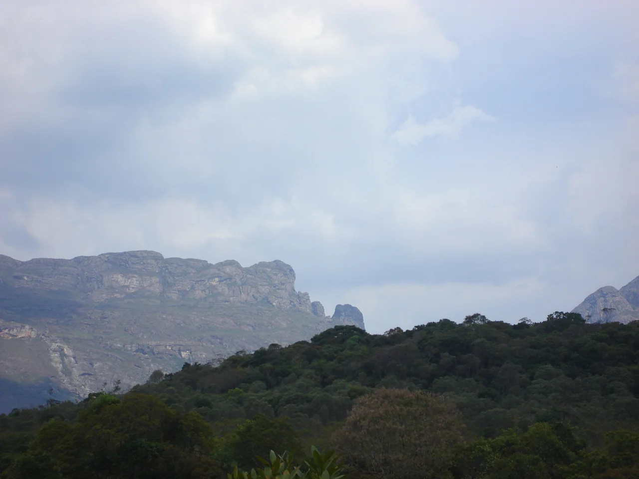
The Last Atlantic Forest
Inside the park boundaries, what survives is a piece of Brazil that once stretched from Rio Grande do Sul to Rio Grande do Norte but has been reduced to about 12 percent of its original extent. The Iron Quadrangle is a transition zone where Atlantic Forest meets Cerrado - the vast Brazilian savanna of the central highlands - and species from both biomes overlap here. The result is unusual biological diversity. Jaguars still live in the park, along with cougars, ocelots, and maned wolves. The brown howler monkey and the masked titi are both present. The chaco eagle, a large raptor rare throughout its range, nests here. The cinereous warbling finch, the collared peccary, the southern tamandua, the long-nosed armadillo - the list of resident mammals and birds reads like a checklist of species considered vulnerable or threatened elsewhere in southeastern Brazil. Serra do Gandarela is their last large connected forest in this part of the country.
Rock Fields and Rare Flora
The vegetation is more varied than the Atlantic Forest designation suggests. Rock fields - campos rupestres - cover the ridgelines where thin soil lies over iron-rich outcrops. Graminous fields, savannas, and proper forests alternate across the slopes. Several plant species in the park carry vulnerable conservation status: Lychnophora pinaster and Lychnophora ericoides, small shrubs endemic to the rocky highland habitats; Dalbergia nigra, the Brazilian rosewood hunted nearly to extinction for its dense black timber; Ocotea odorífera, an aromatic tree once logged commercially for its scented wood; Melanoxylon brauna, and the orchid Oncidium warmingii. The iron-bearing crust that made this land valuable to mining is the same geology that created the unique soil chemistry these endemic species depend on. Preserving the plants means keeping the rocks undisturbed.
The Argument That Continues
The national park exists. The water flows. But the compromise that created it did not end the argument, because the Apollo iron ore project remains a permitted activity on lands immediately adjacent to the park's boundaries. Environmental groups continue to push for expanded protection. Mining interests continue to push for expanded access to the ore body beneath the surface. The communities living near the park, some of whom were unhappy with the original park boundaries because they restricted traditional land use, have their own complicated position. What Serra do Gandarela illustrates, more clearly than many parks, is that conservation in a mineral-rich country is always a negotiation - between a drinking water supply and a revenue stream, between a forest that took millions of years to develop and an ore body that took a billion years to form. The 2014 decree settled one round. There will be others.
From the Air
Serra do Gandarela National Park is centered at 20.07 degrees south, 43.66 degrees west, about 40 km southeast of Belo Horizonte. The park covers 31,270 hectares across eight municipalities, primarily Santa Bárbara, Rio Acima, Raposos, Itabirito, and Ouro Preto. Recommended viewing altitude 5,000-8,000 ft AGL for terrain clearance; the range reaches around 1,500 m elevation. The park appears as a forested highland rising sharply from the mining-scarred valleys around it - the contrast with the iron ore operations to the east and north is visually dramatic. Belo Horizonte Confins (SBCF) is about 60 km to the northwest; Pampulha (SBBH) is about 45 km northwest. Morning fog is common in the valleys; afternoon thunderstorms dominate the wet season November through March.
Nearby Stories
- Kubitschek Residence Museum 22 km away
- Inconfidência Mineira 28 km away
- Crucilandia 29 km away
- Robert Quayle (1814 ship) 53 km away
- Paraopeba 67 km away
- Serra dos Cocais 74 km away
- Viçosa, Minas Gerais 79 km away
- Our Lady of the Rosary Church, Lavras 120 km away