Crucilandia
Some towns change names the way others change decades. Crucilandia, in the hills southwest of Belo Horizonte, has been called at least six different things in the last two centuries - Barra, Campo das Flores, Gamba, Santa Cruz das Aguas Claras, Dom Silverio, and finally, since a 1943 decree, the hybrid Latin-Germanic coinage that means simply Land of the Cross. Seven thousand six hundred people live there today, on 167 square kilometers of rolling hills 97 kilometers from the state capital. The town is small enough that its river and its patron saint share a lineage, and large enough to have held onto its festivals through eighty years of modernization.
The Cross by the Clear Stream
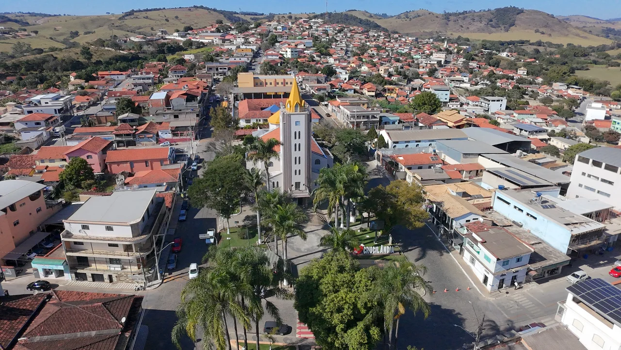
The earliest plausible origin story involves Fernao Dias Paes Leme, the legendary Paulista bandeirante who led an expedition through these hills around 1674 looking for emeralds. Two members of that expedition, Portuguese settlers from Alcobaca, are said to have stayed behind on the banks of a clear-flowing stream and planted a wooden cross. The settlement that grew up around it called itself Santa Cruz das Aguas Claras - Holy Cross of the Clear Waters. A competing tradition dates the founding a century and a half later, to early 19th-century prospectors who decided to remain because of the landscape, the water, and the flecks of gold visible in the streambed. Either way, the cross stuck. The first chapel was built in 1860 by a landowner named Manoel Caetano Pereira.
Gamba, and Other Names
Among the town's earlier names is one the municipal historians mention with some embarrassment: Gamba, meaning opossum in Portuguese. It was a popular, slightly pejorative nickname based on the behavior of some of the earliest inhabitants - probably a joke at the expense of the small settlement's rough edges. In 1880 the village was elevated to a Peace District and got its first formal name: Santa Cruz das Aguas Claras. It then cycled through more refined variants over the next sixty years: Santa Cruz de Dom Silverio in 1910, Dom Silverio in 1923, Dom Silverio do Bonfim in 1938 (added because another town had the same name). In 1943 State Decree-Law 1,058 made it Crucilandia, a neologism built from Latin cruci and the Germanic suffix landia. The town had rejected Campina Verde and Entrocamento for the same slot.
Emancipation and the River That Feeds Belo Horizonte
Political emancipation came five years later. On December 27, 1948 Crucilandia became an independent municipality, separating from Bonfim under State Law 336. The first mayor, Moacir Flores, was appointed. A few months later voters elected Ronan Gumercindo de Souza as the first popularly chosen mayor, with pharmacist Joao Bartolozzi as vice mayor. The town sits at about 908 meters above sea level, with peaks rising to 1,214 meters along the border with Itaguara and Piracema. The Ribeirao das Aguas Claras - known locally as the Rio Manso, the Gentle River - rises in the municipality and feeds the Serra Azul reservoir system that supplies a substantial portion of Belo Horizonte's drinking water. The town's name and the capital's water come from the same hills.
Festivals, Cavalcades, and Ox Carts
The patron saint's feast, Dia da Santa Cruz, falls on May 3 and still draws crowds. The Feast of Saint Gerard on October 16 is a smaller but devoted celebration. Twice a year - in January and October - the town hosts the Encontro de Folias de Reis, a gathering of Three Kings folklore groups with bells, fiddles, flags, and call-and-response song. The Festa do Peao Boiadeiro is a rodeo; the Encontro de Carros de Bois is an ox cart parade with the wheels deliberately un-oiled so they sing their ancient creaking music; horseback cavalgadas cover the rural roads. On Sundays farmers set up a market in front of the Darcy Ribeiro Municipal School. The calendar here is marked by the liturgical year and the agricultural year and the folkloric year at once.
Climate and the Rainy Summer
The climate is the classic Cwa of the Koppen classification - highland tropical with hot rainy summers and mild dry winters. Annual average temperature is 21.8 degrees Celsius. February is the warmest month at 23.2; July the coolest at 18.2. About 1,272 millimeters of rain fall each year, concentrated overwhelmingly in the October-to-March wet season - some 86 percent of the annual total. The dry half of the year gets the remaining 14 percent. In the wet months thunderstorms boil up over the granite-and-gneiss ridges in the afternoons, visible for fifty kilometers from any approaching flight. The town is quiet. The landscape around it is not: Crucilandia sits in a working Brazilian countryside of pastures, small farms, rocky outcrops, and narrow valleys that catch every shadow the sun draws.
From the Air
Located at 20.38 degrees S, 44.34 degrees W, 97 km southwest of Belo Horizonte in the Metropolitan Mesoregion of Minas Gerais. Best viewed from 3,000 to 5,000 feet AGL to see the hilly terrain around town - local elevations range from 873 meters at the valley confluences to 1,214 meters at the high ridges. Look for the Serra Azul reservoir system that the Rio Manso feeds. Nearest airport is Belo Horizonte/Pampulha (SBBH), about 104 km (56 nm) northeast; Tancredo Neves/Confins International (SBCF) is 153 km (83 nm) east-northeast. Main road access is via MG-040 and BR-381.
Nearby Stories
- Savassi 12 km away
- Nova Lima 37 km away
- São Gonçalo do Pará 41 km away
- Bom Despacho, Minas Gerais 43 km away
- Lagoa da Prata 65 km away
- São João del-Rei 67 km away
- Hospital Colônia de Barbacena 73 km away
- Boa Esperança, Minas Gerais 83 km away