Shei-Pa National Park
The salmon should not be here. Landlocked in cold mountain streams at 1,500 meters above sea level, Taiwan's Formosan salmon are relics of the last ice age - Pacific salmon that swam upriver tens of thousands of years ago and never returned to the sea. When the glaciers retreated and the climate warmed, these fish adapted to freshwater life in the high creeks of what is now Shei-Pa National Park, surviving in pools shaded by ancient cypress canopy where the water stays cold enough to sustain them.
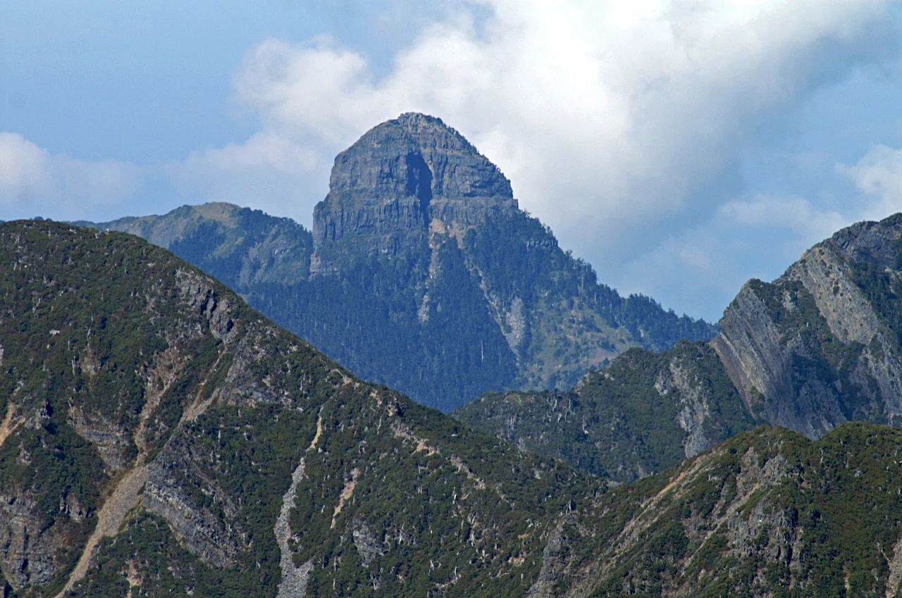
Shei-Pa sprawls across the border of Hsinchu, Miaoli, and Taichung Counties, a wilderness of ridgelines, creek valleys, and cloud forest established as Taiwan's fifth national park in 1992. Its Chinese name - Xueba, meaning "snow overlord" - hints at what dominates the landscape: Xueshan, the Snow Mountain, Taiwan's second-highest peak at 3,886 meters, and Dabajianshan, the Holy Ridge, whose jagged profile has earned comparisons to the Matterhorn.
The Snow Overlord's Domain
Xueshan anchors the park's eastern boundary, a massive peak whose summit collects snow in winter and disappears into cloud for much of the year. The mountain's flanks drop steeply into valleys where rainfall averages 3,152 millimeters annually - and in some areas exceeds 4,000. January temperatures hover around 6.6 degrees Celsius; even July averages a cool 14.9. This is not tropical Taiwan as most visitors imagine it. This is alpine country, fogbound and cold, where the air smells of wet cypress and the trails vanish into mist.
The park's terrain supports four distinct recreation areas, each offering a different window into the landscape. Wuling Recreation Area, established in 1963 as a farm providing employment for retired servicemen, sits on the eastern slope and serves as the primary gateway. On its high terraces, farmers cultivate Wuling Tea at 2,000 meters - leaves grown so slowly in the thin, cold air that they develop an intensity lowland tea cannot match.
Ice Age Survivors in Mountain Streams
The Formosan landlocked salmon is Shei-Pa's most celebrated and most vulnerable resident. Classified as a critically endangered subspecies of cherry salmon, these fish require water temperatures below 17 degrees Celsius and clear, unpolluted streams with gravel beds for spawning. They occupy a vanishingly small habitat: a handful of tributaries in the Chichiawan Creek watershed, all within the park's boundaries.
Conservation efforts have stabilized the population, but the margin remains thin. Climate change pushes stream temperatures upward. Typhoons scour the gravel beds. Agricultural runoff from upstream areas threatens water quality. The park administration monitors the salmon with the intensity of a hospital tracking a critical patient - counting individuals, measuring water chemistry, removing barriers to migration between pools. That this fish exists at all, ten thousand years after the conditions that brought it here vanished, is a small biological miracle.
Cloud Forests and the Holy Ridge
Below the alpine zone, Shei-Pa's mountains wear dense forests of cypress, hemlock, and giant fir. The cloud forest belt, perpetually swathed in fog between 2,000 and 3,000 meters, supports an ecosystem where epiphytes coat every branch and mosses carpet the forest floor in luminous green. Bamboo thickets fill the gaps where landslides have opened the canopy, growing back with the speed that only subtropical bamboo can manage.
The Holy Ridge traverse - connecting Xueshan to Dabajianshan along a knife-edge ridgeline - is among Taiwan's most demanding alpine routes. Climbers contend with rockfalls, cliff exposure, and weather that can swing from clear skies to whiteout fog in minutes. The park recommends traveling in groups with experienced guides, and the visitor centers stock basic first aid supplies for those who underestimate the mountains. Injuries beyond the capacity of these simple kits require a call to the national park management office, which coordinates evacuation to hospitals that lie hours away down winding mountain roads.
Xuejian and the Quieter West
On the park's northwestern flank, near Taian Township in Miaoli County, the Xuejian Recreation Area offers a different character entirely. This is Shei-Pa's newest and least developed section, where the access roads remain rough and the crowds thin. The name means "snow view," and on clear winter days, the lookout points deliver on that promise - panoramas of snow-dusted peaks rising above valleys still blanketed in subtropical forest.
Xuejian's relative isolation preserves something the more accessible areas have lost: silence. Without the steady traffic of tour buses and hiking groups, the forest sounds assert themselves - the drip of condensation from cypress needles, the territorial calls of Formosan blue magpies, the distant rush of water over rock. At night, with no light pollution to compete, the sky over Shei-Pa fills with stars so dense they seem to press down on the mountains. Visitors who camp here often describe the night sky as the single most beautiful thing they encountered in Taiwan.
From the Air
Located at 24.39°N, 121.14°E in central-northern Taiwan, Shei-Pa National Park covers rugged mountainous terrain between Hsinchu, Miaoli, and Taichung Counties. Xueshan (3,886m) is the dominant peak visible from the air. Taiwan Taoyuan International Airport (RCTP/TPE) lies approximately 80km to the northwest. Hsinchu Air Base (RCPO) is closer at roughly 40km. The terrain is extremely mountainous with peaks exceeding 3,500m; expect turbulence and rapidly changing weather conditions, especially during the April-August rainy season. Cloud cover is frequent. Best aerial views are from the east, looking across the Wuling valley toward the Snow Mountain massif.
Nearby Stories
- Lukang Ai Gate 3.1 km away
- Gaomei Lighthouse 5.1 km away
- Beipu 7.6 km away
- Kavalan Distillery 13 km away
- 1916–1917 Nantou Earthquakes 15 km away
- Qingshui Cliff 15 km away
- 1951 East Rift Valley Earthquakes 21 km away
- Taiwan Strait 70 km away