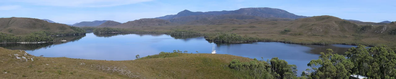

Southwest National Park
One road. Across more than six thousand square kilometres of mountains, moorland, and drowned river valleys, the Southwest National Park has a single road, and it runs only to a small hydro township at the northern edge before the wilderness swallows everything beyond. The rest, the whole vast southern and western reach of Tasmania's largest national park, you can enter only on foot, by boat, or in a light aircraft bumping down onto a gravel strip in the middle of nowhere. This is one of the great temperate wildernesses left on the planet, a place of buttongrass plains and serrated peaks and rain that falls more often than it does not, and humans have barely touched it.
Forty Thousand Years of Quiet
People have known this country far longer than the silence suggests. Aboriginal Tasmanians lived in the southwest for roughly 40,000 years, cut off from mainland Australia when the sea rose and flooded the land bridge some 8,000 years ago. In caves now within the neighbouring Franklin-Gordon park, archaeologists have found tools, bones, and hearths reaching back at least 34,000 years. The South West nation was one of nine across the island, and its clans, the Mimegin, Lowreenne, Ninene, and Needwonne, moved with the seasons, gathering shellfish and crayfish on the coast and hunting wallaby and wombat across the plains. Those plains themselves may be partly their handiwork: there is evidence the buttongrass moorland spread more widely than nature alone would allow, encouraged by generations of careful burning to open ground where game could feed.
The Last Country on the Map
Europeans were slow to come, and slower to stay. Abel Tasman glimpsed this coast in 1642, but no one even knew Tasmania was an island until Bass and Flinders sailed around it 156 years later. The first overland expeditions, in the early 1830s, were led by George Augustus Robinson and guided by Indigenous Tasmanians including Truganini and Woureddy, who knew the country Robinson was crossing. Robinson named many of its landmarks, and, acting under colonial policy, removed the Aboriginal people who remained, part of the catastrophe that befell Tasmania's first nations. In 1854 the surveyor James Sprent reached Port Davey and became the first European to sight a great spire of rock he called the Obelisk. We know it now as Federation Peak, one of the most fearsome climbs in Australia, a tooth of quartzite that still turns back all but the most committed walkers.
The Lake That Was Lost
The park's heart began as something smaller and tragic. In 1955 the government protected the country around Lake Pedder, a glacial lake famous among bushwalkers for a beach of unique pink quartz sand that one writer thought would have stood beside Uluru and the Great Barrier Reef in the national imagination, had it survived. It did not. In the early 1970s the lake was flooded for hydroelectric power, drowning the pink beach and driving species like the Pedder galaxias, a small native fish, toward extinction in the wild. The loss was so raw that it galvanised a young conservation movement, which would soon fight and win the battle for the nearby Franklin River. The park kept growing around the wound, reaching its present 6,183 square kilometres by 2000 and earning World Heritage listing along the way.
Where the Parrots Still Fly
For all its harshness, the southwest is a stronghold of rare life. Cyclonic winds, frost in summer, more than two metres of rain a year, and yet the park shelters hundreds of plant species and dozens of animals found only here. Its most famous resident is the orange-bellied parrot, a small, brilliantly coloured bird that breeds nowhere else on Earth but within a few kilometres of Melaleuca Lagoon, then flies the length of Tasmania's west coast to winter on the mainland. The species teeters on the edge: fewer than a hundred birds remain in the wild, propped up by nest boxes, feed tables, and a captive population watched bird by bird. To walk here, on the Port Davey Track or the South Coast Track, is to move through country that asks for ten to fourteen days, fuel stoves instead of campfires, and boots scrubbed clean of disease at hygiene stations. The park does not make itself easy. That is exactly why it has survived.
From the Air
The Southwest National Park covers the bottom corner of Tasmania, centred near 42.83 degrees south, 146.15 degrees east. From the air it is a study in roadless country: serrated ranges, golden-brown buttongrass plains, the deep inlets of Port Davey and Bathurst Harbour cutting in from the wild south coast, and the broad expanse of impounded Lake Pedder near the northern boundary at Strathgordon. The unmistakable spire of Federation Peak stands out among the southern ranges. The remote airstrip at Melaleuca serves light aircraft only; the nearest significant fields are Cambridge Aerodrome (ICAO YCBG) and Hobart International (YMHB), about 60 to 80 nautical miles to the northeast. Weather is the defining hazard here, with frequent low cloud, rain, and strong westerly to southwesterly winds straight off the Southern Ocean. Clear flying days are uncommon; when they come, a viewing altitude of 4,000 to 6,000 feet reveals the full sweep of ranges, moorland, and drowned valleys.
Nearby Stories
- Macquarie Harbour Penal Station 19 km away
- Franklin Dam Controversy 31 km away
- Mount Wellington (Tasmania) 53 km away
- Macquarie Harbour 59 km away
- Bruny Island 65 km away
- Van Diemen's Land 68 km away
- Port Arthur 145 km away
- Chatham Islands 3042 km away