
St Mary's Airport, Isles of Scilly
Before there was a runway here, planes landed on the golf course. In 1937, Channel Air Ferries began scheduled service from Land's End to the Isles of Scilly, and the pilots simply set their de Havilland Dragons down on the fairways between Hugh Town and Porth Hellick Bay. Two years later, in August 1939, the Council converted High Cross Farm into a proper airfield, just in time for the Second World War to define what flying to these islands actually meant. Today the airport sits a single nautical mile east of Hugh Town, owned by the Duchy of Cornwall, operated by the Council of the Isles of Scilly, and serving as the only fixed-wing connection between Britain's southwestern-most populated rocks and the mainland thirty miles away.
A Runway Carved from a Farm
High Cross Farm became an airport in August 1939, and the conversion was as humble as it sounds. Photographs from the opening show a small group of dignitaries - Earl Amherst representing Great Western and Southern Air Lines, the chairman of the Isles of Scilly Steamship Company, the captain of the local golf club - standing on freshly graded ground. There was no glamour to the project. The Isles of Scilly needed a faster link than the Penzance steamer, and a flat patch of west-facing Cornish granite was what they had to work with. The Dragons that had been touching down on the golf course since 1937 now had a dedicated strip, and within months the airfield was at war.
The Dragon and the Dragon Rapide
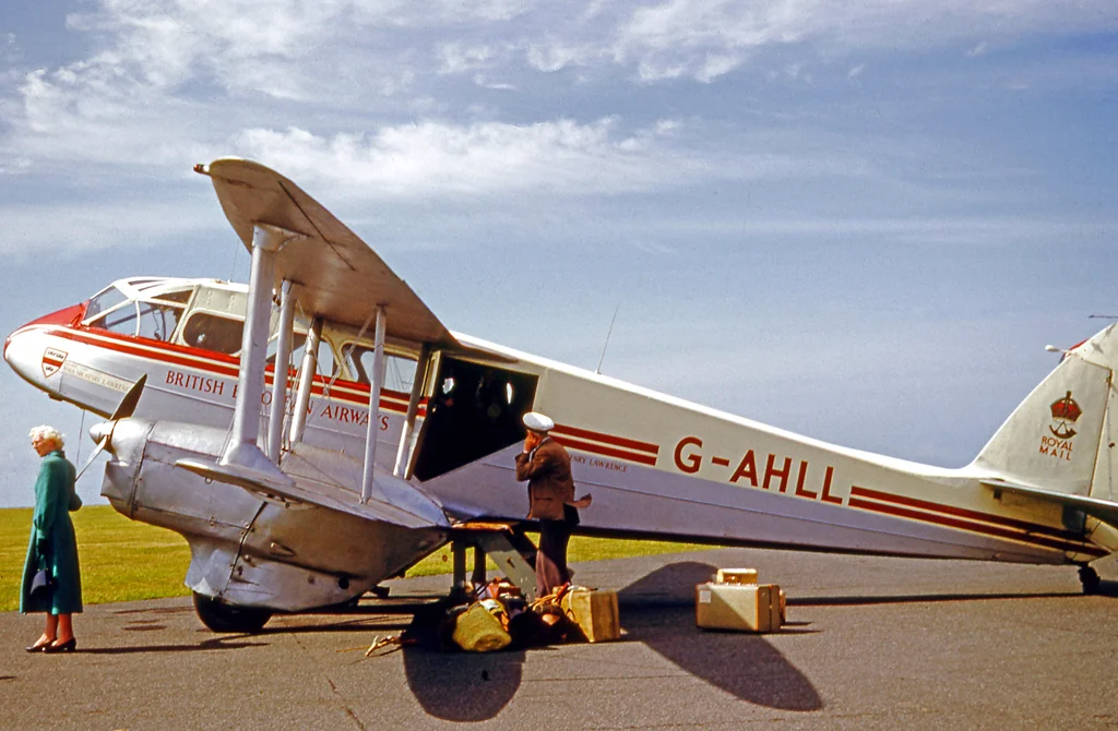
Great Western and Southern Airlines took over the route in 1938, replacing the original twin-engined Dragons with the slightly larger de Havilland Dragon Rapides during the war years. These were fabric-and-plywood biplanes, designed for short hops to communities that no other aircraft could reach. They flew through everything the Atlantic threw at them - low cloud, gale-force winds, the kind of visibility that would ground modern airliners. In February 1947 British European Airways absorbed the operation. The Dragon Rapides kept flying the Land's End route until 1964, when BEA replaced them with a single Sikorsky S-61 helicopter operating from a new heliport at Penzance. For the next forty-eight years, helicopters defined the journey to Scilly.
The Disaster of 1983
On 16 July 1983, a British Airways Helicopters Sikorsky S-61 on a routine scheduled flight from Penzance crashed into the sea two nautical miles short of St Mary's Airport. Nineteen passengers and one crew member were killed. Six people survived - four passengers and two crew - pulled from the cold Atlantic by the St Mary's Lifeboat, the same RNLI station that has guarded these waters since 1837. The crash remains one of the worst civilian helicopter accidents in British history. The Penzance helicopter service continued after the disaster but ended entirely in 2012, and a new commercial helicopter operation only resumed in 2020. For islanders, the route between mainland and home has always carried risk; the 1983 crash made that risk impossible to ignore.
The Footpath and the Runway
A public footpath crosses within a few metres of the southern end of the runway, and it is closed by warning lights and bells a few minutes before each take-off or landing. Walkers stop, the bells ring, a small twin-engined Britten-Norman Islander or de Havilland Twin Otter from Isles of Scilly Skybus thunders past at head height, and then the lights go green and life resumes. The airport doubles as a base for emergency services - the Cornwall Air Ambulance, the HM Coastguard Search and Rescue aircraft from Newquay, the Isles of Scilly Fire and Rescue Service. In 2014 the European Commission approved a £6.5 million upgrade for runway resurfacing, new navigational aids, and terminal improvements. The little airfield is still a working farm of a place, set into the landscape rather than imposed on it, but it is also the lifeline that keeps these islands inhabited year-round.
From the Air
St Mary's Airport (ICAO: EGHE, IATA: ISC) sits at 49.91 N, 6.29 W, elevation 116 ft, one nautical mile east of Hugh Town on St Mary's. Single asphalt runway 15/33, approximately 600 metres. No instrument approach - VFR only, weather is the dominant operational factor. Nearest mainland diversions: Land's End (EGHC) 28 nm northeast, Newquay (EGHQ) 60 nm northeast. The airfield is unmistakable from the air: a single strip cut across the eastern side of an emerald-green island ringed with white beaches and turquoise shallows. Watch for the footpath crossing at the southern threshold.
Nearby Stories
- Penlee Lifeboat Station 5.5 km away
- Black Swan Project 20 km away
- Tater Du Lighthouse 25 km away
- The Brisons 31 km away
- 1979 Fastnet Race 54 km away
- SM U-27 110 km away
- HMS Affray 149 km away
- Tower of Hercules 700 km away