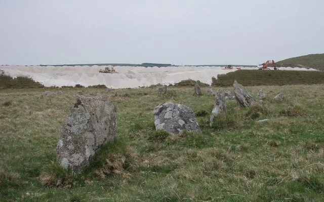

Stannon Stone Circle
Stand in the supposed centre of the circle and turn until your shoulder points to a compass bearing between twenty-two and twenty-eight degrees north of east. There, on the skyline, is Rough Tor. Whoever raised these stones some four thousand years ago made sure of that sightline. They flattened the ring on its northern side, as Alexander Thom would later classify it - a Type A flattened circle, like its neighbour at Fernacre - and they set it deliberately on the gentle slope of Dinnever Hill, two streams running past on either side. Two and a half miles south-east of Camelford, on the open western edge of Bodmin Moor, Stannon waits. The only company you are likely to meet are moor ponies and the wind.
Counting the Stones
Stannon contains 47 upright stones, 30 recumbent on the ground, and 2 that have shifted out of position - 79 in total, spaced regularly around an oval roughly 42.6 metres by 40.5 metres. Four further stones stand outside the main ring, jagged and isolated. Most are about half a metre tall. The largest has a base over 1.2 metres wide. This is not the kind of circle that batters you with scale, like Avebury or Stanton Drew. It works at a human dimension - you can walk its full perimeter in a few minutes, stand within it, see every stone from every other. The remoteness is the point. Aubrey Burl, the great cataloguer of British stone circles, argued that Stannon may be older than the more famous Stripple Stones to the south, a contention echoed by the surveyor John Barnatt. Late Neolithic or early Bronze Age - somewhere in that thousand-year window, somebody decided this slope mattered enough to ring it in granite.
The Settlement Below the Circle
In the late 1960s, the archaeologist R. J. Mercer dug at Stannon Down, the broader landscape that contains the circle. He uncovered eight round houses from a settlement that probably held more than twenty, each between six and eight metres across, with fields for cultivation and rectangular enclosures that may have served as stock corrals. The houses were posts and thatch, partitioned with timber, floored with paved stone or compressed earth. Pottery turned up. Flint tools. A whetstone, suggesting the residents had metal blades to keep sharp. Pollen analysis showed that the area had once been mixed oak woodland - the kind of forest the first settlers would have cleared to make space for their homes and crops. The settlement is dated to the Middle Bronze Age, somewhat later than the circle itself, which means whoever lived here lived alongside a monument already old and built by people they may never have known. The population was probably around a hundred.
The Quarry on the Hill
The view that frames Stannon today is not entirely ancient. To one side, the slope rises to a vast china clay works - white scars and tiered terraces cut into the moor, conveyor belts and settling ponds, the industrial extraction of kaolin that has shaped this part of Cornwall for two hundred years. The contrast is jarring, and the older guidebooks tend to describe the quarry, with audible disappointment, as having blighted the landscape. But the truth is more layered. The same china clay that built modern Cornwall's economy was created by the same granite that the circle builders used. The Neolithic monument and the modern quarry are working with the same stone, just at different scales of patience. From most angles inside the circle, the quarry stays out of frame. You can stand among the stones and see only moorland and the long ridge of Rough Tor to the north-east.
Sunrise on the Horizon
What was Stannon for? The honest answer is that nobody knows. But the alignments suggest something. The nineteenth-century researcher Matthew Gregory Lewis noticed that the relationship of these moorland monuments to their surrounding hills indicated deliberate consideration of sunrise positions at particular times of year. The modern archaeologist Andy M. Jones has reviewed the studies of the area and called Stannon part of a ceremonial complex - one piece in a larger ritual landscape that includes Fernacre, Rough Tor, the cairns and barrows of the surrounding moor. Astronomical observation, ancestral remembrance, communal gathering, marking of the seasons - any or all of these may explain why people raised the stones. Probably it was all of them at once. The certainty is that whoever stood in the centre of this ring four thousand years ago saw what we can still see: Rough Tor on the eastern horizon, the sky moving across the granite, the same long slope of Dinnever Hill running down toward the streams.
From the Air
Located at 50.589°N, 4.650°W on the western edge of Bodmin Moor. Recommended viewing altitude 2,000-3,500 ft AGL to take in the ceremonial landscape connecting Stannon to Fernacre (200 m east) and Rough Tor (1 mi north-east). Visual landmarks: the white scars of Stannon china clay works rise immediately west; Crowdy Reservoir lies 0.7 nm north-east; Camelford sits 2.5 nm north-west. The site is unsigned from the air; look for the irregular oval of stones on the gentle slope south-east of the quarry. Nearest civilian airports: Newquay (EGHQ) 22 nm south-west, Exeter (EGTE) 56 nm east. Moorland mist forms quickly; check visibility before low-level passes.
Nearby Stories
- Gunnislake 1.5 km away
- Tehidy Country Park 4.2 km away
- Caerhays Castle 8.1 km away
- Bude 15 km away
- Hope Cove Lifeboat Station 26 km away
- Appledore Lifeboat Station 29 km away
- Godrevy Lighthouse 34 km away
- Action of 17 November 1917 82 km away