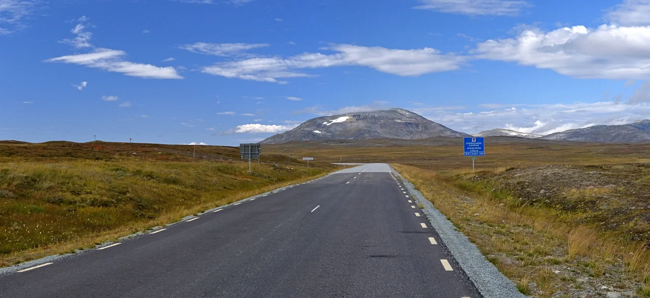

Stekenjokk
On the evening of 18 January 2017, the anemometer on the Stekenjokk plateau logged an average wind of 47.8 metres per second, or 172 kilometres per hour. It was the strongest sustained wind measured anywhere in Sweden since national records began in 1951, and the strongest single gust that day reached 201.6 km/h. The station was already the record holder: 47 metres per second during Cyclone Hilde in November 2013. A typical Swedish storm averages around 25 metres per second, enough to make walking upright difficult. The reason one weather station keeps winning is simple. Up here there is nothing left standing to slow the air down.
Above the Last Tree
Stekenjokk straddles a county line, belonging partly to Strömsund Municipality in Jämtland and partly to Vilhelmina Municipality in Västerbotten, a few kilometres from the Norwegian border and Børgefjell National Park beyond it. The name is half Sami: jokk means watercourse. This is bare fell, a subarctic climate too cold to grow trees, and the emptiness is the point. There is no precipitation gauge at the SMHI station, but Gäddede, lower down and not far away, takes more rain and snow than the Swedish average, and Stekenjokk's winters run cold and long enough that the snowpack lingers into early summer. Drifts of six or seven metres are ordinary. The nearest municipal seats give a sense of the isolation: Vilhelmina is 130 kilometres away by road, Strömsund 180.
Twelve Years of Copper
The plateau also held one of Sweden's more remote industrial gambles. Parliament debated state support for opening a mine at Stekenjokk in 1973, preparatory work began that summer, and Boliden brought the underground operation into production in 1976. It ran until October 1988. Over those twelve years roughly seven million tonnes of ore came out of the rock, carrying about 1.5 per cent copper, 3 per cent zinc and some 50 grams of silver per tonne. Around 170 people worked there at the peak. The ore was concentrated on site, trucked down to Lövliden and put on rail for the Rönnskär smelter on the coast. Then the world copper price fell far enough that the numbers stopped working, and Boliden shut the mine. What the company left behind was a scar on bare fell at high altitude, where almost nothing grows back on its own.
Teaching a Tailings Field to Grow
Restoring ground like this is slow, unglamorous work. In 2020 Boliden and the consultancy Ecogain took a five-hectare patch of the old site and tried a five-step recipe on it. Sewage sludge mixed with wood chips went down about two centimetres deep, to release nutrients over several years rather than all at once. An excavator loosened the surface, creating pockets sheltered enough for seed to germinate in a place where the wind is the main enemy. Seed was sown by hand, then rolled in so the wind could not simply take it away. Finally came dwarf birch seedlings, grown from seed collected locally. One choice reveals who the land belongs to: the knotweed seed used makes good reindeer grazing, which the Sami communities here value. The methods worked; the cold summers made ripening seed on site the hardest part.
Reindeer and a Government Decision
Stekenjokk is summer pasture. Reindeer from Vilhelmina södra sameby graze the moor through the warm months, and the herding work itself is part of what visitors come to see. The plateau is a bird protection area and a Sami cultural landscape, and it carries rules to match; in 2012 the reserve was closed to the public for months after thieves took eggs from nests, reopening only once the birds had a chance to lay again. That balance is now under pressure. Bluelake Mineral, formerly Vilhelmina Mineral, has pursued reopening since 2017. Sweden's mining inspectorate said no in October 2024, the company appealed, and in May 2026 the government granted the processing concession, rejecting objections from the Vilhelmina södra and Voernese Sami communities. Mining is restricted to November through April, on the reasoning that the reindeer are elsewhere then. Vilhelmina södra maintains it has reindeer in the area year-round. An environmental permit from the land and environment court is still required.
Four Months of Road
Vildmarksvägen, the Wilderness Road, runs 360 kilometres from Strömsund to Vilhelmina by way of Gäddede, Jormvattnet, Stora Blåsjön, Stekenjokk, Klimpfjäll, Kultsjön and Saxnäs, and locals call its high section Stekenjokkvägen after the pass. Climbing to roughly 870 metres, it is among the highest public roads in Sweden and arguably the highest paved one. The plateau stretch opens on 6 June and closes on 15 October; for the remaining seven and a half months the snow simply wins. Concrete bunkers built between 1940 and 1945 sit along the route, poured when Sweden expected a German advance from Norway. Drive it in July and the fell runs green and open to the horizon in every direction, with reindeer on the road and the old mine road branching off into the emptiness.
From the Air
Located at 65.090N, 14.463E on the border between Strömsund Municipality (Jämtland) and Vilhelmina Municipality (Västerbotten), a few kilometres east of the Norwegian frontier. The plateau is bare, treeless fell at roughly 800-900 metres, with Vildmarksvägen crossing it at about 870 metres; the road and the disused mine access tracks are the clearest man-made features in an otherwise empty landscape. Børgefjell National Park lies immediately west across the border, and the lake Stora Blåsjön lies south along the road. Recommended viewing altitude 4,000-8,000 ft AGL. Nearest airports: Vilhelmina (ESNV) about 55 nm east-northeast, Mosjøen Kjærstad (ENMS) about 55 nm west-northwest in Norway, Hemavan Tärnaby (ESUT) about 80 nm north-northeast, Sveg (ESND) far to the south. Expect extreme winds - this station holds the Swedish record for sustained wind speed - plus rapid cloud formation over the plateau, icing in the cold season, and snow cover from mid-October into early summer.
Nearby Stories
- Susendal Church 2.5 km away
- Børgefjell National Park 9.8 km away
- Unkervatnet 22 km away
- Kittelfjäll 24 km away
- Stora Blåsjön 24 km away
- Limingen 24 km away
- Norra Storfjället 59 km away
- Lapplandsleden 91 km away
Sources
- Stekenjokk - Wikipedia
- New wind record as powerful storm sweeps through Sweden - The Local
- Stekenjokks koppargruva - Swedish Wikipedia
- Regeringen säger ja till verksamhet i gruvan i Stekenjokk - SVT Nyheter
- Boliden: Efterbehandling av gruvområdet i Stekenjokk - Ecogain
- Vildmarksvägen - Wikipedia and Visit Sweden
- Where to stop along the Wilderness Road - Visit Sweden