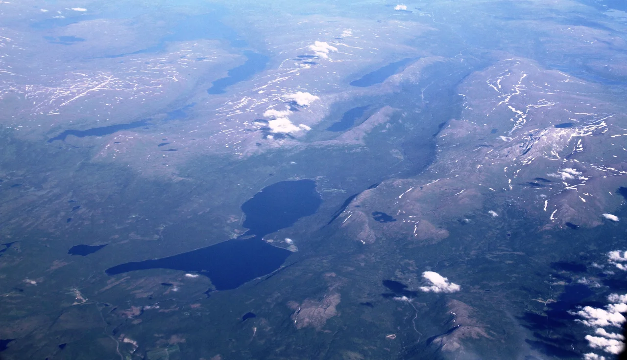

Unkervatnet
In late winter the surface of Unkervatnet will carry a snowmobile, and people drive out onto it to drill holes and sit over them. It is a strange place to be still. Under the auger, at the lake's deepest, the water continues down another fifty-six and a half metres — cold, dark and unhurried — while the person above waits for a char or a trout in a landscape flattened to white by the ice. Nine and a half kilometres of lake stretch away in one direction, and in the other, close enough to walk, runs a road into Sweden.
Åanghkejaevrie
In Southern Sami the lake is Åanghkejaevrie, and that name belongs to a language spoken by only a few hundred people, in a municipality that has made keeping it alive a matter of policy. The water sits at 321 metres above sea level, long and comparatively narrow — about nine and a half kilometres end to end and a little over two across at its widest — with a surface of just over fourteen square kilometres. It averages twenty-seven metres deep and reaches fifty-six and a half at its deepest, which is a lot of water for a lake this modest in area. That the Sami name survives on modern maps at all is worth noticing. Hattfjelldal Municipality made Southern Sami an official administrative language alongside Norwegian in 2017, and took Aarborte as a co-equal name for itself in 2019 — decisions that put names like Åanghkejaevrie back into ordinary official use rather than leaving them as footnotes.
Two Seasons, One Fishery
Unkervatnet has a reputation for trout and Arctic char, and unusually the reputation holds in both halves of the year. Summer fishing is done from boats and from the shore. Winter fishing is done through the ice, which in a place this far north means several months of access rather than a novelty weekend. Arctic char are a cold-water fish, at home in exactly this kind of deep northern lake, and they hold in the depths through the warm weeks before moving shallower as the surface chills. Two places serve the visitors who come for it: Ørnes camping at the eastern end of the lake, and Tjolmen on the north side about halfway along. Neither is elaborate. Neither needs to be.
One River In, One River Out
Water enters chiefly from the east by the Skardmodalselva, with the Gardsbekken, Sanderbekken and Sandskardbekken adding smaller volumes. It leaves at the other end as the Unkerelva, which joins the Vefsna. That connection places this quiet lake inside the largest river system in Nordland — 163 kilometres of river rising at Simskardvatnet in Børgefjell and draining 4,122 square kilometres before it reaches the sea at Mosjøen. The Vefsna was one of Norway's great salmon rivers, and then it was not: the parasite *Gyrodactylus salaris*, introduced into Norwegian watercourses in the twentieth century, took the fishery apart. The story of the Vefsna is a large one, and Unkervatnet is a small, cold, healthy tributary chapter of it.
The Road to Dikanäs
Along the northern shore runs the road from the village of Hattfjelldal to Dikanäs in Sweden — one of very few places in this stretch of the mountains where a driver can cross the frontier at all. The border here is not a wall of peaks but a long, high, open shoulder of country, and the road takes the lake as its natural line. East of the water, toward the border, lies the Skardmodalen nature reserve. The traffic is thin. What passes is mostly local, mostly seasonal, and mostly familiar with the conditions, which is the sensible attitude to a road that spends half the year in snow and never had many alternatives to begin with. For the farms and cabins strung along the shore this is not scenery, it is the way out — north to the village of Hattfjelldal and its airstrip, or east over the watershed to the Swedish side, where the nearest sizeable settlements are a long drive further on.
From the Air
Unkervatnet lies at 65.4983°N, 14.1856°E in Hattfjelldal Municipality, Nordland, with a surface elevation of 321 m (1,053 ft). From the air it is an unmistakable landmark: a dark, elongated lake about 9.5 km long and 2.3 km at its widest, oriented roughly east–west, with a road tracking its northern shore toward the Swedish border. Its outflow, the Unkerelva, runs to the Vefsna, and the much larger reservoir of Røssvatnet lies to the northwest. Recommended viewing altitude 3,000–5,000 ft AGL for the length of the lake and its valley walls; go higher for the Børgefjell peaks to the south. Nearest airport is Hattfjelldal (ENHT), a 715 m concrete general-aviation strip about 15 km northwest at the village, with no scheduled service and no instrument approach; Mosjøen Kjærstad (ENMS) is the nearest field with airline service, and Mo i Rana Røssvoll (ENRA) lies to the north. Vilhelmina South Lapland (ESNV) serves the Swedish side. Expect ice cover from roughly November into May, valley fog on still mornings, and rapid deterioration when weather moves in over the border ridge.
Nearby Stories
- Ranseren 7.4 km away
- Røsvatnet 12 km away
- Grane Municipality 13 km away
- Majavatn 17 km away
- Hemavan 17 km away
- Vefsn Municipality 22 km away
- Kittelfjäll 43 km away
- Lapplandsleden 132 km away