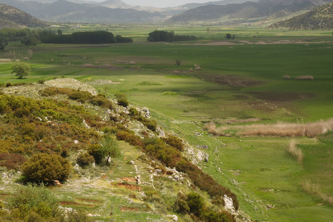

Stymphalus (Arcadia)
Pindar called Stymphalus "the mother of Arcadia," and for a city that disappeared long before he was born, that is a remarkable thing to say. The ancient city is gone — swallowed by earthquakes, time, and the Romans — but the plain it once commanded is still here: a flat, mountain-ringed bowl in the northeastern Peloponnese, about six miles long, sealed on all sides by slopes that rise to the massive bulk of Mount Cyllene in the north. At the center, a lake fills and empties in ways the ancient Greeks found inexplicable, because the water drains not through any visible river but downward, into the earth, through a subterranean passage that the ancients believed carried it all the way to the Erasinus River in Argolis, 200 stadia away. This is the landscape that myth chose for one of Heracles' twelve labors. It was not chosen carelessly.
The Lake That Breathes Underground
No river drains Lake Stymphalia. Instead, the water exits through a subterranean channel at the foot of Mount Apelaurum, on the plain's southern edge — and ancient writers believed it resurfaced, after a hidden underground journey, as the Erasinus River far to the east in Argolis. Whether or not that is true, the lake's behavior is strange enough to have invited the supernatural. The geographer Pausanias, writing in the 2nd century CE, reported that in his own time an inundation had covered the plain, and the people attributed it to the anger of Artemis. The channel had become blocked, the water rose, and the goddess was blamed.
The Roman emperor Hadrian found a more practical use for the springs feeding the lake: he commissioned an aqueduct to carry their water all the way to Corinth, and considerable remains of that engineering work can still be traced across the landscape today. The Athenian general Iphicrates, according to Strabo, once tried to obstruct the underground outlet while besieging Stymphalus — and abandoned the attempt only after what was described as a heavenly sign dissuaded him. Even in strategy, the lake had a way of stopping armies.
The Birds That Heracles Came to Drive Away
The sixth labour of Heracles brought him to this plain to deal with the Stymphalian birds — creatures celebrated throughout the ancient world, though their exact nature was never quite agreed upon. Pausanias described them as the size of cranes, shaped like ibises, but with stronger, uncurved beaks. They were said to be man-eating, or at least catastrophically numerous, fouling the countryside with their droppings and their menace. Heracles drove them away with a great rattle, a gift from Athena.
The city of Stymphalus did not let the story lie forgotten. The temple of Artemis Stymphalia, the only building Pausanias bothers to describe, had figures of the birds carved under its roof, and behind it stood marble statues of young women with the legs and thighs of birds — the human-avian boundary blurred, as myth tends to blur it. Silver coins minted here showed Heracles on one face and a Stymphalian bird on the other, with the inscription ΣΤΥΜΦΑΛΙΩΝ. The birds were the city's emblem, its claim on the wider imagination.
A City Rebuilt on a Grid
Excavations since 1982, directed by Hector Williams for the University of British Columbia, have revealed that the Stymphalus visible in the archaeological record is largely a 4th century BCE refoundation — a planned city built on a Hippodamian grid, with six-metre-wide roads running north-south every 30 metres, crossing major east-west avenues at intervals of more than a hundred metres. This is urban design, deliberate and rational, applied to a site enclosed by mountains and prone to flooding.
Within that grid, archaeologists have found a theatre, a palaestra, a fountain house still functioning in its original form, several temples, and a sanctuary where an inscription fragment reading POLIAD — meaning "of Athena Polias" — was discovered by Anastasios Orlandos in 1925, though it has since been lost. The sanctuary was frequented largely by women, to judge by the large quantities of copper and bronze jewelry recovered there, and loom weights in an annex point to a weaving workshop connected with Athena's cult. The Romans destroyed the sanctuary in 146 BCE, though lamps from the early Roman period suggest later visits.
Soldiers, Settlers, and Silence
After the Hellenistic grid city, a different kind of occupant arrived. Excavations in other parts of the town uncovered a fine early Roman villa — marble furniture, painted wall plaster, a cavalry sword, a shield — destroyed in an earthquake around 40 CE. The villa's occupant may have been a veteran officer from Octavian's army, settled in the northern Peloponnese after the Battle of Actium in 31 BCE; this region received a number of such veteran colonists. The luxury of the fittings suggests rank and comfort, even here, in a mountain plain that floods unpredictably.
Late Roman and early Byzantine settlers left five small cemeteries near the ancient city, spanning the late 4th to mid-6th centuries CE, though no church or house from this period has yet been found. The ancient city Homer mentioned in the Catalogue of Ships — one of the places whose troops Agapenor led to Troy — had by then been gone for centuries. What remained was a place people kept returning to, drawn perhaps by the water, the plain's agriculture, or the simple fact of walls still standing.
Myth, Grid, and Monastery
Just north of the ancient city stands the ruined Cistercian monastery of Zaraka, built by the Franks in the early 13th century — another layer in a landscape that accumulates eras rather than shedding them. The plain of Stymphalus is like that: myth on top of Bronze Age traces on top of a planned classical city on top of Roman villas on top of Byzantine graves, and then Frankish Gothic arches at the northern edge. The ancient source of the Stymphalus river rises on the northern side of the plain, cold and copious, and the 4th-century BCE fountain house nearby still works. Some things here are remarkably durable.
From the Air
Stymphalus lies at approximately 37.86°N, 22.46°E in the northeastern Peloponnese highlands, roughly 65 km southwest of Corinth. The mountain-enclosed plain and Lake Stymphalia are visually distinctive from altitude — look for the flat basin surrounded on all sides by steep ridges, with the elongated lake at its center. Recommended viewing altitude: 3,000–5,000 ft for the best view of the plain's geography and the lake's relationship to the surrounding mountains. Nearest airport: LGRX (Araxos / Patras), approximately 60 km to the northwest. Flying in from the north, the peak of Mount Cyllene (2,376 m) is a prominent landmark; the Stymphalian plain opens directly south of it.
Nearby Stories
- Siege of Corinth (1463) 2.1 km away
- Aigeira 2.7 km away
- Oblou Monastery 3.7 km away
- Isova 4.9 km away
- Mantinea 5.2 km away
- Arkadiko Bridge 8 km away
- 1981 Gulf of Corinth Earthquakes 11 km away
- Battle of Lalas 20 km away