_delegates_in_Peking_in_1761.jpg)
Sulu Archipelago
The Sulu Archipelago is not, as many suppose, the remnant of a land bridge between Borneo and the Philippines. It is something more dramatic: the exposed edge of submarine ridges, pushed up by the tectonic tilting of the ocean floor, crowned by the eroded cones of extinct volcanoes. Basilan, Jolo, Tawi-Tawi, and the hundreds of smaller islands that compose the chain form the boundary between two seas, the Sulu to the north and the Celebes to the south. Sometimes called Basulta, from the first syllables of its three provinces, the archipelago stretches southwest from Mindanao like a curving arm reaching toward Borneo.
Islands Born from the Deep
The geology tells the story of forces operating on a scale that makes human history look brief. The islands sit along submarine ridges produced by the collision of tectonic plates, their volcanic cones rising from the southernmost ridge in the chain. Tawi-Tawi, the most remote major island, has a serpentine basement-complex core capped with limestone, a composition that speaks to an ancient oceanic origin. The Tausug, the dominant ethnic group, have inhabited these islands for centuries, intermarrying with Kapampangan and Tagalog Muslims known as Luzones who were based in Brunei. Long before European cartographers mapped the chain, these waters were highways for traders, raiders, and missionaries moving between the Malay world, the Philippines, and China.
The Sultanate's Stronghold
In 1405, the Sultanate of Sulu made the archipelago the seat of an Islamic maritime state. Founded by Sharif ul-Hashim, the sultanate controlled not just these islands but portions of Borneo, Mindanao, and Palawan. From the beginning, the Spanish Empire contested this claim. Miguel Lopez de Legazpi established a colony in Cebu in 1565, and by 1578 a Spanish captain was negotiating with the Sulu sultan, extracting tribute in pearls. What followed was a conflict that spanned three centuries. The Spanish attacked Jolo in 1587, 1596, 1598, 1600, 1628, 1630, and 1638, each time either failing to hold the island or withdrawing after brief occupation. The Joloanos responded with raids on Spanish settlements across the Visayas, creating a cycle of attack and reprisal that defined life in the region.
Colonial Chess in Island Waters
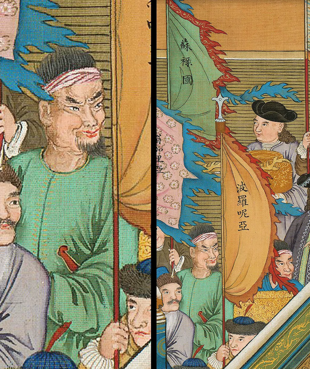
The archipelago became a contest ground for European empires. After the Seven Years' War, the British occupied Manila from 1762 to 1764, then withdrew south to establish trading alliances with the Sulu Sultanate through the British East India Company. Spain responded by directing its attacks on Jolo toward weakening British commercial interests. In 1798, the British Royal Navy, operating from a base in Sulu, bombarded Fort Pilar in Zamboanga. Meanwhile, the sultanate maintained its own diplomatic connections, sending delegates to Beijing and maintaining tribute relations with Ming dynasty China. By 1876, Spain finally assembled a force large enough to hold Jolo permanently: 9,000 soldiers aboard 11 transports, 11 gunboats, and 11 steamboats under Admiral Jose Malcampo. Even then, the Spanish were never secure. They built walls, forts, and tower gates, but the fortified town was sporadically attacked by warriors the Spanish called ajuramentados.
The American Chapter and Beyond
Spain's hold ended in 1898 when the United States defeated the Spanish fleet at the Battle of Manila Bay. The Philippine-American War followed, and after it, the Moro Rebellion of 1899 to 1913 continued the independence struggle against new occupiers. World War II brought Japanese conquest and then Allied liberation. Philippine independence in 1946 did not bring stability to the archipelago. Jolo suffered catastrophic destruction in 1974 during military operations against Moro independence forces, with bombardment and fire reducing much of the town to rubble. The fortification walls that had survived Spanish and American occupation crumbled. Today, fragments of degraded perimeter wall survive, hidden behind buildings or reduced to less than a meter in height. The archipelago was part of the Autonomous Region in Muslim Mindanao and now falls under the Bangsamoro framework, the latest attempt to balance Moro self-governance with Philippine sovereignty.
From the Air
Coordinates: 6.00°N, 121.00°E. The archipelago stretches roughly 300 km from Basilan (near Zamboanga) southwest to Tawi-Tawi, with Jolo island at its center. The chain is visible from high altitude as a curving line of islands between two distinct seas. Key airports include Jolo Airport (RPMJ) and Sanga-Sanga Airport (RPMN) in Tawi-Tawi. Zamboanga International Airport (RPMZ) is the major gateway. The islands are volcanic in origin, with peaks visible from cruising altitude. Be aware of military operations and potential airspace restrictions.
Nearby Stories
- Japanese Destroyer Tanikaze 49 km away
- Basilan 51 km away
- Isabela, Basilan 79 km away
- Tawi-Tawi 87 km away
- 2018 Lamitan Bombing 115 km away
- Sheikh Karimul Makhdum Mosque 153 km away
- Tubbataha Reef 303 km away
- November 2023 Mindanao Earthquake 378 km away