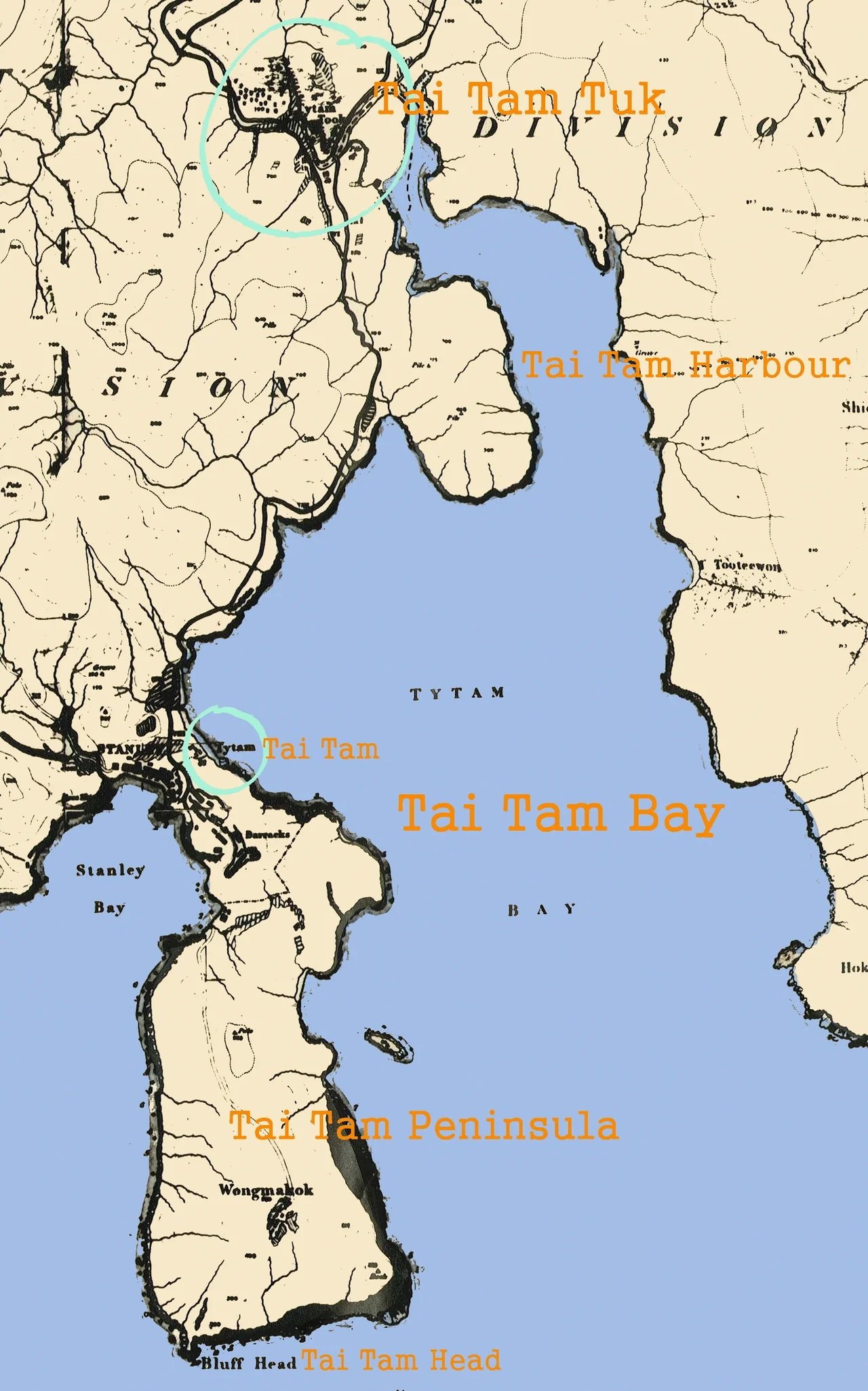

Tai Tam
Tai Tam means "big pool" in Chinese. When the British sloop HMS Sulphur, commanded by Sir Edward Belcher and Sir Henry Kellett, surveyed this triangular bay in January 1841 — just months after the Convention of Chuenpi formally ceded Hong Kong Island to the Crown — the name they found waiting for them was already old. They recorded it as "Tytham" in the ship's charts. The bay held a small fishing settlement facing the sea and, behind it, a valley running north into the hills. Both the name and the landscape have proved remarkably durable in a city that typically demolishes the past before it can become heritage.
A Bay Between Headlands
Tai Tam Bay is a near-perfect triangle, its three corners anchored by Stanley Peninsula to the west, D'Aguilar Peak to the northeast, and Tai Tam Tuk — the "innermost of Tai Tam" — at its base. Tai Tam Tuk is the precise geographical name for the valley at the bay's head, and it once supported a farming settlement of considerable size. That village was eventually relocated to Tai Tam Harbour to make room for the Tai Tam Tuk Reservoir, which occupies the valley floor today. The name migrated with the people. Tai Tam Head, the southeastern cape of what used to be called the Tai Tam Peninsula, still appears on maps as the outermost point of the bay — a geographic label that survived even as the political geography around it changed repeatedly.
December 1941 in the Hills
The Tai Tam area saw heavy fighting between Commonwealth and Japanese forces in December 1941, when the Battle of Hong Kong compressed 18 days of defence into an increasingly desperate retreat across the island's ridgelines. The hills around Tai Tam — the same hills that cradle the reservoirs — channelled troops and blocked retreat. The account is brief in most histories, easily passed over in favour of the larger battles at Wong Nai Chung Gap or the Repulse Bay Hotel. But the soldiers who moved through this green valley, among the same granite outcrops that the dam-builders had quarried a generation earlier, did so in the knowledge that the island would fall. The reservoir road that threads these hills was both a supply route and a retreat path. It served neither purpose well enough.
Tytham to Tai Tam: A Name's Second Life
Colonial romanisation was inconsistent enough that the same place could appear on maps as Tytham, Tai Tam, and Tytam depending on decade and cartographer. The name settled into its current form gradually through the twentieth century as Hong Kong's place-name standardisation efforts worked their way across the territory. By the time the Southern District of Hong Kong Island was formally established as an administrative unit, Tai Tam had stabilised as a distinct neighbourhood rather than a general geographic description. Today it refers specifically to the area around Tai Tam Tuk — the reservoir, the country park, and the scatter of low-rise residential developments that line Tai Tam Road below the dam.
Green Belt and Glass Towers
Tai Tam Road is one of the more arresting contrasts on Hong Kong Island. It runs from Wong Nai Chung Gap south through the country park and then curves past a series of luxury residential towers — buildings with names like The Manhattan, Le Palais, and Villa Rosa — before reaching the harbour. The Red Hill neighbourhood in the southern part of Tai Tam Tuk is known for low-rise upmarket housing: the Redhill Peninsula, Turtle Cove, Red Hill Park. The Hong Kong International School occupies the hillside above Tai Tam Road, and the American Club's larger campus sits on the valley floor. The Tai Tam Scout Centre edges the harbour shore. This is Tai Tam's present: a patchwork of carefully preserved green space, well-maintained reservoir infrastructure, and some of the most expensive residential addresses on the island.
Citizen Science at the Dam's Foot
Near the foot of the Tai Tam Tuk dam, the Tai Tam Tuk Eco Educational Centre runs programmes focused on sustainable development and ecological literacy. The centre hosted one of Hong Kong's first BioBlitz events, in which volunteers and scientists spend 24 hours cataloguing every species in a defined area. In a dense city where few people have direct contact with undeveloped land, projects like these carry a particular weight. Tai Tam's green buffer — preserved because the reservoir catchment needed to stay clean — turns out to be a rare outdoor classroom. The water infrastructure that saved the city from thirst also saved a fragment of the landscape that teaches people why nature is worth saving.
From the Air
Tai Tam is located at approximately 22.238°N, 114.224°E on the southeastern side of Hong Kong Island. From the air at 2,000–4,000 feet, the triangular indent of Tai Tam Bay is visible along the island's southern coastline, with Tai Tam Harbour at its head and the dam face of the Tai Tam Tuk Reservoir marking the transition from settled valley to country park. The surrounding ridgelines — D'Aguilar Peak to the northeast at 381 metres — define the bay's northern boundary clearly. Stanley Peninsula is visible to the west. Nearest major airport: Hong Kong International Airport (VHHH), approximately 34 km to the northwest on Lantau Island. The former Kai Tak site is about 8 km to the north across the harbour. In clear weather, the open green country park interior contrasts visibly with the denser development of Stanley and Shek O on nearby peninsulas.
Nearby Stories
- Lok Ma Chau Loop 2.3 km away
- Portas do Cerco 2.3 km away
- Kweilin Incident 17 km away
- Wanshan Archipelago Campaign 34 km away
- Nanxiong Formation 115 km away
- Battle of Nanpeng Island 148 km away
- Heyuan 169 km away
- Cape Maobitou 632 km away