
Taipa
The Portuguese asked the Chinese settlers the name of the place. The Chinese — shopkeepers who sold groceries and spoke no Portuguese — misheard the Portuguese word for "name" (*nome*) as the Cantonese for "sticky rice" (*nuo mi*), and assumed they were being asked if they had any to sell. "Daai ba," they replied: "a lot." The Portuguese, hearing a place name, called the island Taipa. There is no historical evidence for this story, and the linguists have their own explanation — the Portuguese name comes from the Min Nan pronunciation of the Chinese characters 氹仔. But the legend persists, and it captures something true about Taipa: a place where languages, cultures, and misunderstandings have been accumulating for eight hundred years.
Two Islands, One Name
Taipa began as a pair of islands — Greater Taipa and Lesser Taipa — separated by a central channel and sitting 2.5 kilometers south of the Macau Peninsula. The first settlers were Hokkien-speaking fishermen who arrived around eight hundred years ago, and most Chinese settlement followed during the Southern Song dynasty. Over centuries the gap between the islands silted naturally, and by the mid-twentieth century the two had merged into one. Today Taipa's geography is shaped by two hills — 159.1-metre Colina da Taipa Grande to the east, Colina da Taipa Pequena to the west — with flat, reclaimed terrain between them. The island has not stopped growing: land reclamation connected it to Coloane through Cotai, and what was once a channel is now a strip of casino resorts and convention centres. Taipa, Cotai, and Coloane are all, technically, one island now.
Annexation and Fortress
Portuguese Macau was a trading post before it became a colony in the fuller sense, and Taipa's formal annexation came relatively late. In 1847, under the assertive governorship of João Maria Ferreira do Amaral, Portugal moved to formalize its sovereignty over the islands south of the Macau Peninsula. Lesser Taipa was annexed first, and a fortress — Taipa Fortress — was built on the command of Pedro Jose da Silva Loureiro to suppress maritime pirates and protect the port. By 1851, Greater Taipa had also been incorporated. These moves were part of a wider Portuguese project to expand the colony beyond the peninsula to include Taipa, Ilha Verde, Coloane, and portions of the nearby island of Hengqin. A divided harbour on the peninsula had made the port vulnerable; controlling the surrounding islands resolved the problem and gave the colony room to grow.
The Firecracker Island
Taipa's industrial identity for most of the twentieth century was built not on fishing but on fireworks. The first firecracker factory opened on the island in 1923, and its establishment was partly driven by colonial caution: after a factory accident on the Macau Peninsula in 1925 killed 100 people, officials restricted firecracker manufacturing there, and Taipa — cheaper, less crowded, and more tolerant of risk — absorbed the industry. Factories multiplied, population grew, and the island's economy reorganized around the controlled explosion of gunpowder in paper tubes. By the mid-1980s, cheaper manufacturing elsewhere had undercut the industry, and the last firecracker factory on Taipa closed in 1984. What replaced it — cautiously at first, then overwhelmingly — was the casino economy.
Bridges and Airports
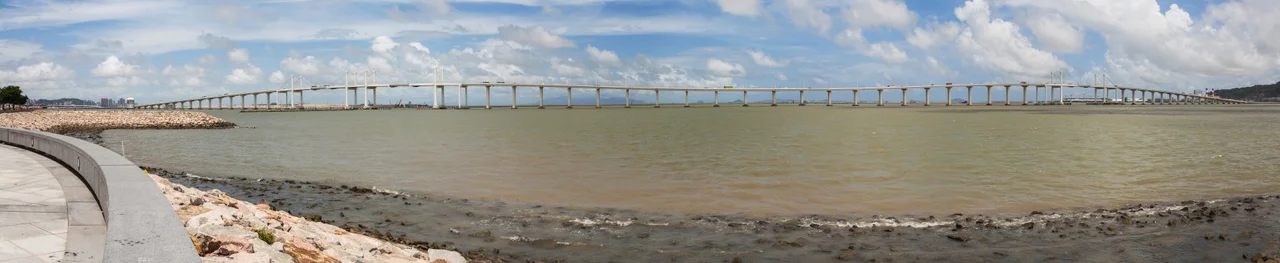
For most of Taipa's history, the island was connected to the Macau Peninsula only by boat. The first bridge, the Governador Nobre de Carvalho Bridge — named after the governor who held office from 1966 to 1974 — opened in 1974, giving Taipa its first fixed link to the city. A causeway connecting Taipa to Coloane had opened five years earlier, in 1969. Two more bridges to the peninsula followed: the Friendship Bridge and the Sai Van Bridge. Then, in 1995, Macau International Airport opened on the eastern coast of Taipa, transforming the island's connectivity overnight and anchoring its future as a hub for regional tourism. These infrastructural additions — one per decade or so across the latter half of the twentieth century — trace the arc of Taipa's transformation from an island community to an urban district.
Old Village, New World
Taipa's old village, clustered around the southern hills and the Portuguese-era streets near the Taipa Houses–Museum, has survived the surrounding development as a district that draws visitors for the contrast it offers. Cunha Street is lined with restaurants; the colonial-era churches and temples sit a short walk apart. The island's Cantonese names — Dragon Ring, Chicken's Neck, Pool — have all been superseded by the Portuguese transliteration that stuck. A population that was originally around 3,000 has grown to over 112,000. The Macau University of Science and Technology, the University of Macau (on adjacent Hengqin Island, technically part of the same civil parish), the Macau Jockey Club, and Macau Stadium are all on Taipa. The old village and the mega-resort strip coexist uneasily, a few hundred meters and several centuries apart, both sharing the same silted, reclaimed, still-expanding island.
From the Air
Taipa sits at approximately 22.16°N, 113.56°E, immediately south of the Macau Peninsula across a narrow channel bridged by three crossings — all visible from altitude. The island's characteristic shape includes two low hills flanking a flat central plain, with the Cotai development strip extending south toward Coloane. Macau International Airport (VMMC) occupies the eastern coast of Taipa and is the primary landmark from the air: a single runway extending into reclaimed water. Recommended viewing altitude: 2,000–5,000 ft for a clear view of the full Taipa-Cotai-Coloane complex, the three bridges to the Macau Peninsula, and the airport. VHHH (Hong Kong International) is approximately 55 km to the northeast, with the Pearl River estuary between. From higher altitude, the density contrast between old Taipa village and the Cotai casino corridor is visually striking.
Nearby Stories
- Tai Tau Chau (Southern District) 0.7 km away
- Lai Chi Wo 3 km away
- Wanshan Archipelago Campaign 3.2 km away
- Pearl River Delta 3.7 km away
- Battle of Yamen 13 km away
- Jiangmen 15 km away
- Hong Kong 12 32 km away
- Battle of Nanpeng Island 114 km away