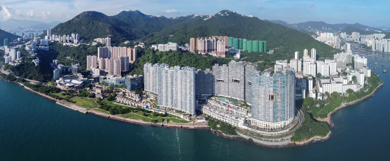

Telegraph Bay
The bay has gone by three names, and each one is a chapter of history. To the people who lived here first, it was Tai Hau Wan — 大口灣 — the big mouth bay, a description of its open, wide-jawed shape as it meets the South China Sea. The British colonial maps called it Taihowan Bay, a phonetic approximation that honored the sound without quite capturing the meaning. Then the telegraph cables came ashore here in the late nineteenth century, and the name shifted again to Telegraph Bay — a name that announced the place had been claimed by something new and global. Today it is also known as Kong Sin Wan, and on its shores stands Cyberport, Hong Kong's technology hub. The bay has been renamed, rewired, and redeveloped, but it has not forgotten itself.
The Cables That Crossed the World
In the late nineteenth century, undersea telegraph cables were the internet of their day — invisible threads of copper and gutta-percha carrying words and numbers across ocean floors at speeds that seemed miraculous to anyone who had grown up waiting weeks for a letter. The China Submarine Telegraph Company, founded by John Pender, chose this bay on the island's western shore as the landing point for cables linking the colony to the wider world. The choice made practical sense: the bay offered shelter, accessible depth, and proximity to the colony's administrative center. Where the cables came ashore, the bay's name followed. Telegraph Bay entered colonial maps and stayed there. The physical infrastructure is long gone — no cable station survives here in visible form — but the name it left behind is one of Hong Kong's most literal: this is a bay that was defined entirely by what once ran through it.
The Flower That Belongs Only Here
Sometime in the late nineteenth century, a botanist or plant collector walking near this bay noticed a flowering tree that didn't match anything in the existing botanical records. The tree had broad, butterfly-shaped leaves and orchid-like blossoms in deep magenta and white. It was a Bauhinia — specifically, what would eventually be named Bauhinia blakeana, after Sir Henry Blake, who had served as Governor of Hong Kong from 1898 to 1903 — the species was formally described in 1908, after his tenure, but named in his honor. The plant was found to be sterile, reproducing only through cuttings, which means every Bauhinia blakeana alive today is a clone of the tree found near Telegraph Bay. It grows nowhere else in the wild. Hong Kong eventually adopted it as the city's symbol: the white flower on the regional flag is a stylized Bauhinia blakeana. The bay's most lasting contribution to Hong Kong may be botanical, not technological.
Cyberport and the Next Signal
The irony is almost too neat: a bay named for nineteenth-century communications infrastructure is now home to Hong Kong's twenty-first-century technology campus. Cyberport, which opened in phases from the early 2000s, sits on the western end of the bay, a cluster of office buildings, residential towers, and tech incubator spaces built on what was previously undeveloped hillside. The development was government-supported and its arrival stirred debate — critics questioned whether it represented genuine innovation policy or a real-estate play dressed in tech language. Whatever the answer, Cyberport has grown into a functioning hub for startups, digital media firms, and financial technology companies. The bay that once received undersea cables now sends data through fiber and air.
Between Sandy Bay and Waterfall Bay
Telegraph Bay sits between Sandy Bay to the north and Waterfall Bay to the south, tucked into the western shoreline of Hong Kong Island below Pok Fu Lam. This is a quieter part of the island, far from the density of Central or the commercial energy of Causeway Bay. The water here faces west toward the Pearl River estuary, and on clear days the hills of the New Territories are visible across the strait. The indigenous name Tai Hau Wan, meaning big mouth bay, referred to the bay's northern opening — though cartographic confusion over the centuries has sometimes shifted that name to the adjacent Sandy Bay. The names have drifted, the coastline has been reshaped, and the big mouth of the bay now opens onto a waterfront that would be unrecognizable to anyone who knew it before the cables arrived.
From the Air
Telegraph Bay sits at approximately 22.267°N, 114.133°E on Hong Kong Island's western shore. Approaching from the west at 2,000–3,000 feet along the Pearl River estuary, the Cyberport development is visible on the hillside above the bay. The bay lies roughly 15 km east of Hong Kong International Airport (VHHH) on Lantau Island. Sandy Bay is immediately to the north, and the steep wooded hillsides of Pok Fu Lam Country Park rise sharply behind the shore. The South China Sea opens to the southwest, and in clear conditions the outer islands are visible from this altitude.
Nearby Stories
- Lok Ma Chau Loop 2.3 km away
- Portas do Cerco 2.3 km away
- Kweilin Incident 17 km away
- Wanshan Archipelago Campaign 34 km away
- Nanxiong Formation 115 km away
- Battle of Nanpeng Island 148 km away
- Heyuan 169 km away
- Cape Maobitou 632 km away