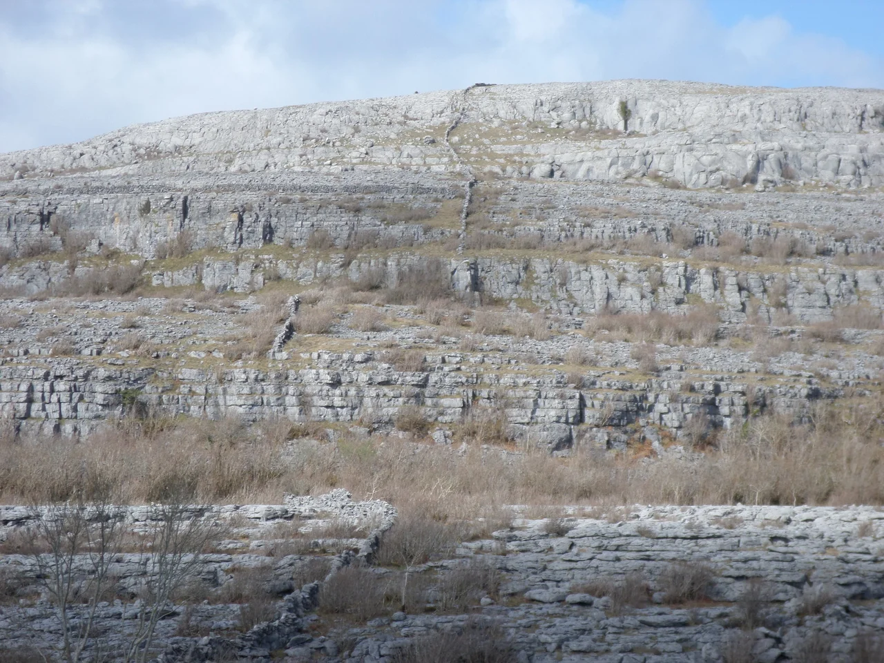

The Burren
Edmund Ludlow's verdict on this place has never quite been bettered. Sent in 1651 to suppress Irish resistance in the wake of Cromwell's conquest, the parliamentary general summarized what he found: "a country where there is not enough water to drown a man, wood enough to hang one, nor earth enough to bury him... and yet their cattle are very fat; for the grass growing in turfs of earth, of two or three foot square, that lie between the rocks, which are of limestone, is very sweet and nourishing." In four hundred years almost nothing about the Burren has changed enough to make Ludlow wrong. It is still a hard place. The cattle are still fat. The grass in the cracks is still impossibly sweet.
A Sea Turned to Stone
The Burren measures roughly 530 square kilometres, centred in northwestern County Clare and bounded by the villages of Lisdoonvarna, Corofin, Gort, and Kinvara. Geologically it is much larger than that - the same Carboniferous limestone extends north under Galway Bay to surface again as the Aran Islands, and east across the Gort plain. The strata formed in a tropical sea about 325 million years ago, when this latitude lay near the equator and the seabed accumulated layer after layer of dead coral, crinoids, sea urchins, and ammonites. The bed of limestone is up to 800 metres thick. Then tectonics lifted it, glaciers scoured it, and rainwater - mildly acidic from atmospheric carbon dioxide - began the slow dissolution that produced the karst surface. The result is a glacio-karst landscape considered one of the world's finest examples.
Where the Arctic Meets the Mediterranean
Over 70 percent of Ireland's species of flowering plants grow in the Burren. That figure is staggering for a region this size, and what makes it stranger is the company those plants keep. Spring gentian - a brilliant blue Alpine flower that elsewhere grows at high altitude in the Alps - blooms here at sea level, sometimes within a few metres of mountain avens, an Arctic plant of cold tundra. Both grow near Mediterranean species like the maidenhair fern that prefers warm rocky places near the sea. The Burren's grikes - the deep cracks in the limestone pavement - trap moisture and shelter dwarf shrubs, while acid-loving heathers like Calluna thrive on thin patches of peat that isolate them from the basic limestone underneath. Twenty-four species of fern. Twenty-two species of orchid. Twenty-eight of Ireland's thirty butterfly and moth species. All seven species of bat. It should not work. It does.
Five Thousand Years of Tombs
Around 33,000 years ago, hunters were already in this landscape - cave deposits hold butchered animal bones radiocarbon-dated to that depth. By the Neolithic, around 4000 BC, settlers had begun clearing trees, building stone walls, and raising megalithic monuments. The Poulnabrone dolmen - a portal tomb whose massive capstone has become one of the iconic photographs of Ireland - was built around 3800 BC. Around seventy megalithic tombs survive in the Burren, more than half of all such structures in County Clare. The late-Neolithic and early-Bronze-Age wedge tombs, mostly built between 2500 and 2000 BC, account for about 90 percent of those - clusters of them survive at Roughan Hill, at Gleninsheen, at Poulaphuca. The Iron Age is harder to date here because the dwellings were perishable, but ringforts like Cahercommaun, Caherconnell, and Ballyallaban speak to centuries of continuous habitation.
The Prince of Burren
The medieval Burren had its own dynasty. The O'Loughlin clan ruled Boireann from their tower house at Gregans Castle down to the mid-17th century, and the head of the family bore the title "Prince of Burren." Their kinsmen the O'Conors ruled west to Liscannor from Dough Castle. Both clans were ultimately subjects of the O'Briens, kings of Thomond, who eventually became the Barons Inchiquin and held the castles at Dromoland and Leamaneh. The villages still bear medieval names: Lisdoonvarna, Ballyvaughan, Noughaval, Carron, Fanore. Family tombs cluster near the altar at Corcomroe Abbey. Then came Ludlow, came Cromwell, came confiscation. The medieval Gaelic political order ended in the 1650s. The walls stayed where they were.
A UNESCO Geopark
The Burren and Cliffs of Moher Geopark, designated by UNESCO in 2011, encompasses an expansive interpretation of the Burren including the Cliffs of Moher to the south. The Burren National Park is much smaller - about 1,500 hectares in the southeast - and is the smallest of Ireland's eight national parks. A proposed visitor centre at Mullaghmore was shelved in the 1990s after the Burren Action Group fought it as inappropriate for the site. Conservation here is delicate. The traditional grazing system - hardy native cattle moved onto upland grasslands from October to April - is what keeps brush like hazel and blackthorn from advancing across the limestone pavement. Research conducted in the 1990s found that the area of pavement had halved since pre-Famine times. The Burren is a paradox: it looks immortal but it isn't. It is sustained by the cattle as much as the cattle are sustained by it.
Caves and Cliffs
The same dissolution that fissures the surface drills tunnels below it. Pollnagollum, one of the longest cave systems in Ireland, runs under the limestone with the Irish Cave Rescue Organisation based nearby at Doolin. The sea cliffs at Ailladie draw rock climbers from across Europe. Walkers cover the Burren Way over five days; the Cliffs of Moher Coastal Walk runs 18 km along the edge of the Atlantic where 200-metre cliffs drop into Galway Bay. In winter the rain comes - 1,525 millimetres annually, more than twice what falls on the east of Ireland. In late May the gentians peak, the avens flower, and for a few weeks the rock turns blue and white at the same time.
From the Air
Coordinates 53.10°N, 9.28°W. The Burren occupies the northwest corner of County Clare, with Galway Bay along its northern shore and the Atlantic to the west. Shannon Airport (EINN) lies 50 km south and is the standard arrival point; Connemara Airport (EICA) is 30 km north across Galway Bay. From altitude the Burren is unmistakable: a pale grey-white expanse of bare limestone framed by greener farmland to east and south and by the dark line of the Cliffs of Moher dropping into the Atlantic to the west. The Aran Islands visible offshore are geological extensions of the same plateau. Best viewed in late May when the limestone pavement and the gentian flowering create the strongest visual contrast.
Nearby Stories
- Ballynahinch Castle 2.8 km away
- Knockmoy Abbey 3.1 km away
- Lough Corrib 4 km away
- Rineen Ambush 6.9 km away
- 2003 Derrybrien Landslide 15 km away
- Saint Macdara's Island 15 km away
- Shannon Region 18 km away
- Magharee Islands 66 km away