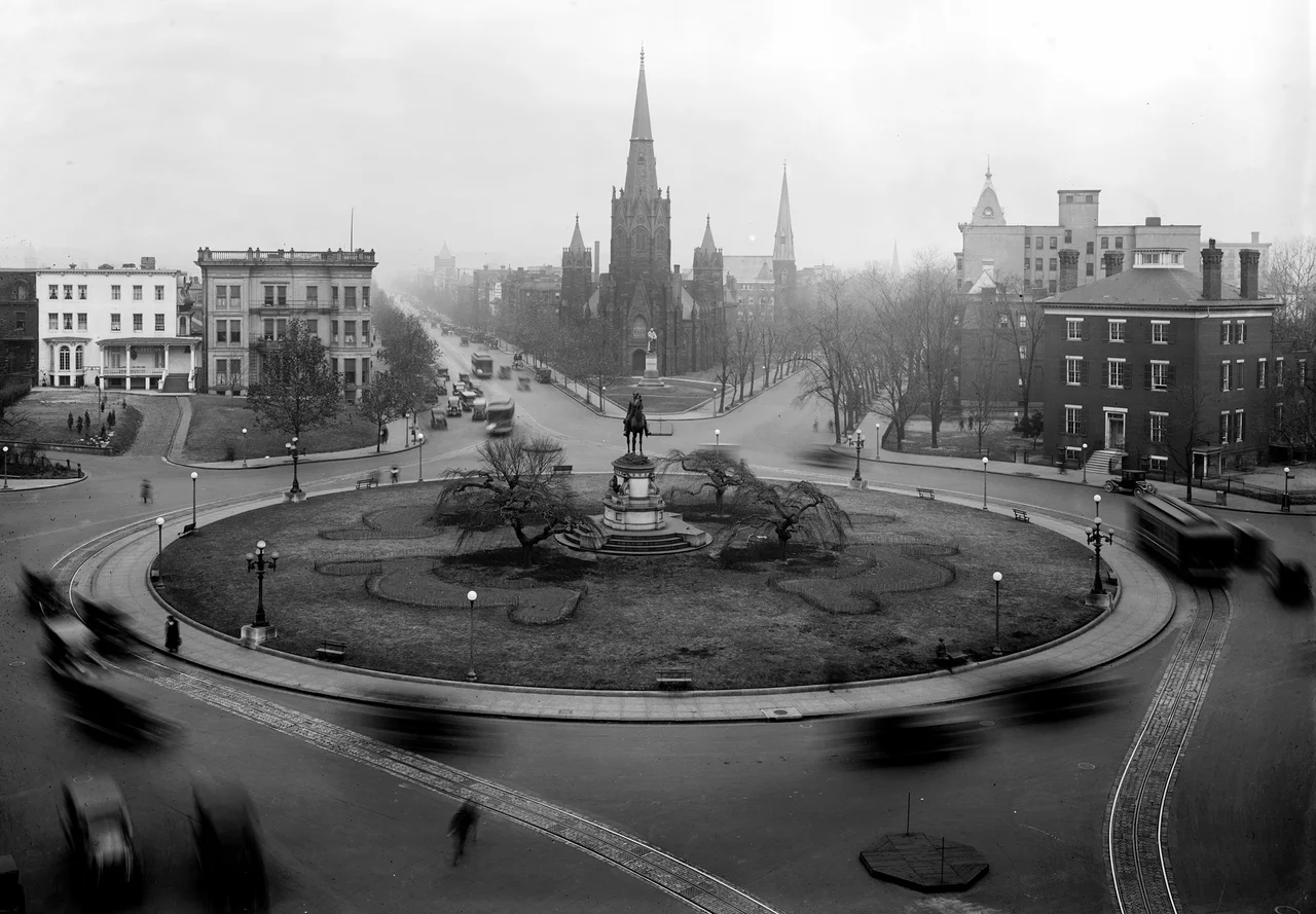

Thomas Circle
George Henry Thomas was a Virginian who chose the Union when Virginia seceded - the rarest of Civil War acts, which cost him most of his family and earned him both Lincoln's trust and the nickname Rock of Chickamauga for refusing to retreat when most of the federal army around him did in September 1863. Fourteen years after Chickamauga, Congress dedicated his equestrian statue at the intersection of Fourteenth and Massachusetts in Washington - the country a Virginian had helped to hold together remembering, in bronze, what that holding had cost. The intersection took his name. Today Thomas Circle marks the boundary between downtown Washington and the gentrifying neighborhoods to the north - a circle within a tunnel within a city, the Massachusetts Avenue underpass running directly beneath the general's horse.
L'Enfant's Drawing
Pierre L'Enfant put an intersection here on his 1791 plan for the federal city - the meeting of Fourteenth Street, M Street, Massachusetts Avenue, and Vermont Avenue NW. By 1792 the plan called for that intersection to be a circle. Development was slow. The area was effectively countryside until after the Civil War, with only a few large houses around the open space. The horse-drawn streetcars that brought commuters from outlying neighborhoods reached the circle in the 1860s; landscape improvements followed under Alexander 'Boss' Shepherd, the Reconstruction-era public-works strongman who shaped much of modern Washington's street grid. New soil was brought in to replace the dead clay; a fountain and ornamental iron vases were installed. Most of the 1872 plantings died because they had not been sunk deep enough - a small civic embarrassment that Shepherd later corrected.
The Rock of Chickamauga
The equestrian statue was dedicated on November 19, 1879. John Quincy Adams Ward sculpted it - the same sculptor who carved the statue of George Washington at Federal Hall in New York and the Henry Ward Beecher monument in Brooklyn. Thomas sits on his horse facing south down Fourteenth Street toward the White House. He had died nine years earlier, in 1870, having survived the war and a postwar tour commanding the Department of the Pacific. His family in Virginia, who never spoke to him again after he chose the Union in 1861, declined to attend the dedication. The Society of the Army of the Cumberland, which Thomas had commanded at Chickamauga and the rest of the Western Theater, provided most of the audience. The statue and its circle were added to the National Register of Historic Places in 1979, on the centennial of the dedication.
Two Churches and a Tunnel
Two churches face each other across Thomas Circle. The Luther Place Memorial Church, built in the early 1870s on the north side as a memorial to those who died in the Civil War and as a symbol of postwar reconciliation, is a Gothic Revival stone building still active as a Lutheran congregation. Across the circle stands the National City Christian Church, a much larger Greek Revival building designed by John Russell Pope (the architect of the Jefferson Memorial and the National Archives) and dedicated in 1930. Both churches are contributing properties to the Greater Fourteenth Street Historic District. Underneath them both runs the Massachusetts Avenue tunnel, an underpass dug in the late 1930s to relieve traffic congestion that had made the circle one of the worst bottlenecks in the city. Construction tore out most of the circle's landscaping. The tunnel opened on March 14, 1940 - the same week, by coincidence, that Soviet and Finnish negotiators signed the Treaty of Moscow ending the Winter War and less than four weeks before the Nazi invasion of Norway on April 9.
The 1952 Mistake
In 1952 the District added north-south through-traffic lanes that cut directly across the circle, leaving the Thomas statue on a small, inaccessible oval island in the middle of moving traffic. Pedestrians could no longer reach the statue without jaywalking across three lanes of cars. The reconfiguration was meant to improve traffic flow and probably did - at the cost of cutting the public park out of public use. For five decades the statue's circle functioned as a roundabout that pedestrians simply orbited from the outside. In the early 2000s the District restored L'Enfant's original layout. The 2006 reconfiguration removed the through lanes, installed four new sidewalks leading from the cardinal directions to the central circle, surrounded the statue with wrought-iron fencing, and made the entire 28,176-square-foot space pedestrian-accessible again. It is one of the small, quiet civic restoration projects that Washingtonians use as a marker of when the city stopped being managed primarily for cars.
Gateway
Thomas Circle today sits on the boundary between two different Washingtons. To the south lies downtown - office buildings, hotels (the Washington Plaza Hotel sits directly on the circle), the law firms and trade associations of K Street, the federal city. To the north lies what city planners now call uptown Fourteenth Street - the gentrifying corridor that runs through Logan Circle, Shaw, the U Street neighborhood, and continues to Columbia Heights. Logan Circle's restored Victorian rowhouses sell for over two million dollars. The U Street historic district that produced Duke Ellington fills with new restaurants every season. Thomas Circle has become, in the District's own planning language, a gateway - the small civic threshold a pedestrian crosses moving from federal Washington into residential Washington. The general the circle is named for might recognize it. He held the line, after all, against forces moving south. The circle holds the line in the opposite direction.
From the Air
Thomas Circle sits at 38.9057 degrees N, 77.0320 degrees W, at the intersection of 14th Street, M Street, Massachusetts Avenue, and Vermont Avenue NW, about ten blocks due north of the White House. From the air the circle is a small green space with a central equestrian statue, flanked by the imposing Greek Revival mass of National City Christian Church on the northwest and the Gothic Revival Luther Place Memorial Church on the north. Best viewed at 1,500 to 2,500 feet AGL; the entire site lies within the Washington FRZ and the prohibited area P-56A. Nearest airports are Ronald Reagan Washington National (KDCA) 3 nm south, College Park (KCGS) 7 nm northeast, and Washington Dulles (KIAD) 23 nm west.
Nearby Stories
- Gunston Hall 1.1 km away
- 2023 Baltimore Shooting 4.9 km away
- Battle of Middleburg 6.6 km away
- Crownsville Hospital Center 10 km away
- Battle of Loudoun Heights 13 km away
- First Battle of Rappahannock Station 20 km away
- Howard County, Maryland 21 km away
- Harriet Tubman Underground Railroad 50 km away