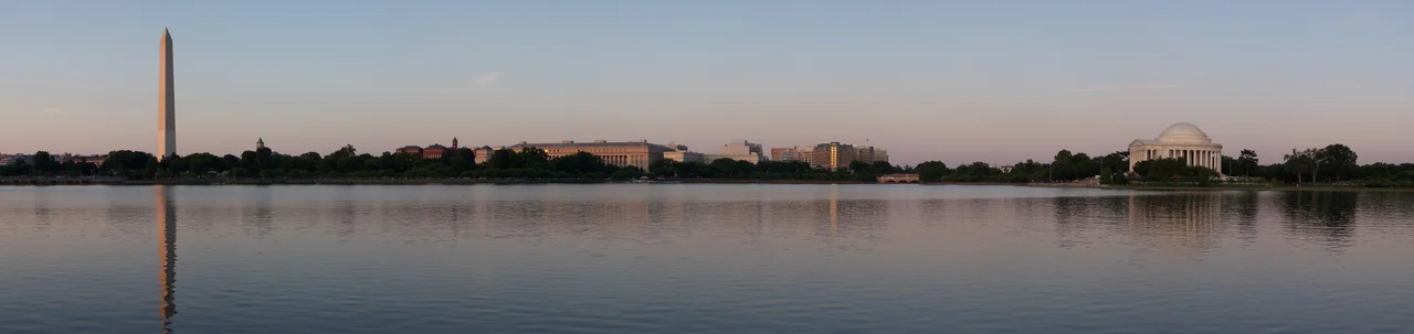

Tidal Basin
In March 1912 the city of Tokyo shipped 3,020 cherry trees to Washington, D.C., as a gift from Yukio Ozaki, the mayor of Tokyo. The trees were Japanese flowering cherries - Yoshino and Kwanzan varieties - and their intended recipient was a 107-acre engineered reservoir along the Potomac River that had been designed to do something entirely different. The Tidal Basin had been built in the 1880s by the Army Corps of Engineers to flush silt out of the Washington Channel. It was a piece of plumbing. The cherry trees were planted around it on March 27, 1912, by First Lady Helen Herron Taft and Viscountess Iwa Chinda, the wife of the Japanese ambassador. Today, every spring, the bloom of those trees and their descendants brings more than 1.5 million people to the basin's edges. The plumbing still works. Hardly anyone notices.
The Channel Problem
By the 1870s, the Washington Channel - the waterway separating the District's wharves from the marshy ground that would become East Potomac Park - was silting up faster than the city could dredge it. The channel served as the federal city's working harbor for steamboats, coal barges, and produce from the Chesapeake. Without a way to keep it flushed, it would slowly close. Major William Johnson Twining of the Corps of Engineers, serving as the District's Engineer Commissioner, proposed in 1879 to create a tidal reservoir that would solve the problem hydraulically. Water entering the basin on the rising tide would be held until the tide began to ebb; then the gates on the channel side would open and the rush of water out would scour the channel clean. Colonel Peter Conover Hains, who would later supervise the Panama Canal's locks, oversaw the design and construction. The basin opened in the 1880s under the name Tidal Reservoir. A 1917 map called it Twining Lake. By the 1920s the original name had returned. The system works twice a day. Two hundred and fifty million gallons of water enter and exit the basin every tidal cycle.
The Cherry Trees
The 1912 gift was actually the second attempt. An initial shipment of 2,000 trees in 1910 arrived diseased and was burned on orders from the Department of Agriculture. Mayor Ozaki, mortified, sent the replacement: 3,020 trees in twelve varieties, carefully fumigated. The planting ceremony in March 1912 began with two trees that Mrs. Taft and Viscountess Chinda put in the ground near what is now the John Paul Jones memorial. The remaining trees were planted around the basin's perimeter and along the Potomac through April. The National Cherry Blossom Festival began in 1935 with a one-day event; it now runs for several weeks each spring. Peak bloom is calculated by the National Park Service from the budding of the Yoshino trees, and varies from year to year - the earliest peak on record was March 15, 1990; the latest was April 18, 1958. As of 2024 the basin and its surroundings hold about 3,700 cherry trees, a mix of original survivors, descendants of the 1912 gift, and later additions.
The Bathing Beach
In August 1918 Congress opened the Tidal Basin Bathing Beach on the shore where the Jefferson Memorial now stands. By one estimate, the beach drew 20,000 visitors on a single July day in 1920. It was racially segregated - Black Washingtonians had a separate beach at Highland Beach in Anne Arundel County, Maryland, founded by Frederick Douglass's son Charles. The Tidal Basin beach hosted bathing-suit beauty pageants until 1922, when a beach official banned them as too risque - which, given that the beach already enforced a rule that women's bathing suits could not stop more than six inches above the knee, gives some indication of how strictly the 1920s were policing the boundary. The beach closed in 1925 - Congress ordered its dismantling specifically to avoid having to integrate it, rather than fund a promised separate beach for Black Washingtonians. The Jefferson Memorial was not built on the site until 1938-1943, more than a decade later. No traces remain on the site.
The Three Memorials
Three presidential memorials now surround the basin. The Jefferson Memorial, designed by John Russell Pope on the model of the Pantheon in Rome, was dedicated in 1943 on the basin's south shore. The Franklin Delano Roosevelt Memorial, designed by Lawrence Halprin as a series of four open-air rooms representing FDR's four terms, opened in 1997 along the basin's western edge. The Martin Luther King Jr. Memorial, designed by Lei Yixin and dedicated in 2011, stands on the northwest shore - a thirty-foot granite figure of King carved as if emerging from a Stone of Hope, with the inscription 'Out of a mountain of despair, a stone of hope' chosen from his I Have a Dream speech. The Washington Monument rises north of the basin. The sight lines among the four monuments form a triangle of American memory that no other body of water in the country can match.
The Sinking Edge
The basin is in trouble. Sea level rise and land subsidence together have caused the paths along the water to flood at high tide. By 2020 the National Park Service was working with the Trust for the National Mall on a re-imagining of the basin's future. After a 2023 environmental assessment, the Park Service announced plans to rebuild approximately 6,800 linear feet of seawall around the basin and West Potomac Park, raising it 4.75 feet higher on a new foundation and widening the walkways from eight feet to twelve. In 2024 the work began, requiring the removal of 158 cherry trees, including the celebrated Stumpy - a small, gnarled specimen on the south shore that had become an internet celebrity in 2022 for its determination to bloom despite leaning against the eroding seawall. Stumpy was cut down on May 28, 2024. Genetic material was preserved; the Park Service plans to replant Stumpy's clones once the new seawall is finished. The basin's plumbing will continue to work. The pageantry around it will continue to draw a million and a half people each spring. The water will continue to rise.
From the Air
The Tidal Basin sits at 38.8870 degrees N, 77.0376 degrees W, on the National Mall's southwestern edge between the Potomac River and the Washington Channel, immediately south of the Washington Monument. From the air the basin is unmistakable: an oval body of water about 107 acres in size, with the white Pantheon-style Jefferson Memorial on its south shore, the FDR Memorial's open-air pavilions on the west, the Martin Luther King Memorial on the northwest, and the cherry-tree ring along its perimeter. Best viewed at 1,500 to 4,000 feet AGL; the entire site lies within the Washington FRZ and the prohibited area P-56A. Nearest airports are Ronald Reagan Washington National (KDCA) 2 nm south, College Park (KCGS) 8 nm northeast, and Washington Dulles (KIAD) 22 nm west.
Nearby Stories
- Gunston Hall 1.1 km away
- 2023 Baltimore Shooting 4.9 km away
- Battle of Middleburg 6.6 km away
- Crownsville Hospital Center 10 km away
- Battle of Loudoun Heights 13 km away
- First Battle of Rappahannock Station 20 km away
- Howard County, Maryland 21 km away
- Harriet Tubman Underground Railroad 50 km away