The Bay on the Fault Line
The water in Tomales Bay is deceptively still. Sheltered from Pacific swells by Inverness Ridge, the bay stretches thirteen miles in a near-perfect line northwest from Bolinas - a line so straight it looks drawn with a ruler. It was, in a sense, drawn by something far more powerful. Tomales Bay fills the rift valley of the San Andreas Fault, the boundary where the Pacific Plate slides past the North American Plate at roughly two inches per year. The granite on the west shore and the sedimentary rock on the east came from entirely different geological origins, separated by millions of years of tectonic movement. On the surface, though, it is simply one of the most beautiful bays in California - warm enough for swimming, calm enough for kayaking, and quiet enough that the loudest sound on a summer afternoon is the crunch of shells underfoot.
Eight Thousand Years on the Shore
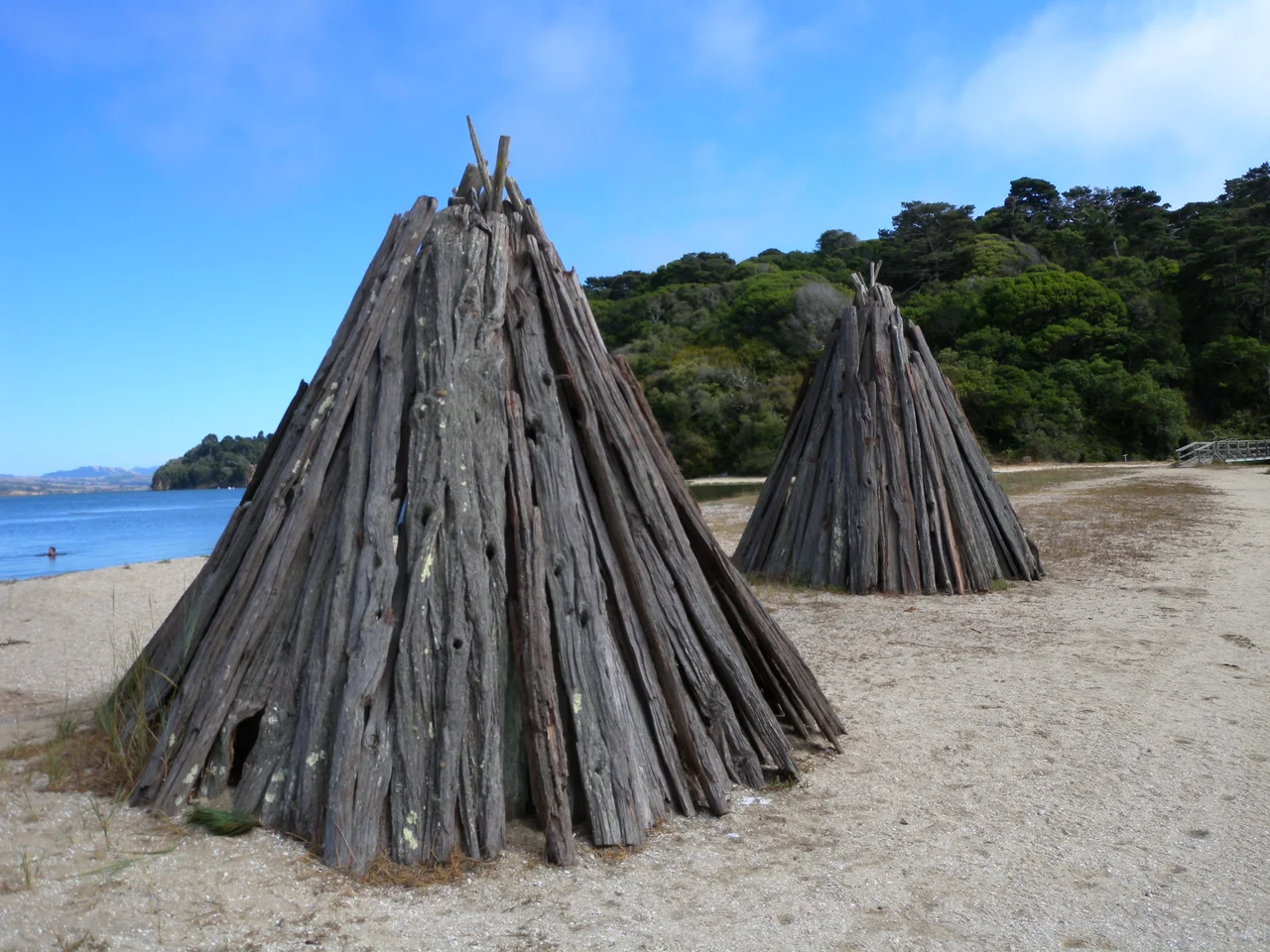
The Coast Miwok made their home along Tomales Bay for millennia before any European sail appeared on the horizon. They built villages near the water's edge, harvested shellfish from the tidal flats, hunted deer in the surrounding hills, and gathered acorns from the bishop pines and live oaks. Their basketry - woven from local grasses and reeds - ranked among the finest in California, intricate enough that some baskets could hold water. At Indian Beach, two reconstructed Miwok bark shelters called kotchas still stand, their tall conical frames a reminder that this shoreline was home long before it became a park. An interpretive trail explains how the Miwok read the tides, the seasons, and the movements of fish and game with a precision that sustained their civilization for over eight thousand years.
Three Kings and a Privateer
Sir Francis Drake sailed into these waters in 1579, during his circumnavigation of the globe, though the exact location of his landing remains debated to this day. What is certain is that the Spanish explorer Sebastian Vizcaino arrived roughly 25 years later and named the peninsula La Punta de Los Tres Reyes - the Point of the Three Kings - in honor of the Feast of the Epiphany. The English eventually anglicized this to Point Reyes. The peninsula's remoteness kept it largely undeveloped through the Spanish, Mexican, and early American periods. While the rest of Marin County filled with towns and roads, Point Reyes remained a place of dairy ranches, coastal fog, and isolation - qualities that would ultimately save it from the development that consumed so much of the Bay Area's shoreline.
Saving Heart's Desire
By the mid-twentieth century, private buyers had begun purchasing beach frontage along Tomales Bay, threatening to close off public access to the shoreline. Conservation groups and the state of California responded by acquiring key parcels, and on November 8, 1952, Tomales Bay State Park opened. The park encompasses roughly 2,000 acres divided between the western and eastern shores of the bay. Heart's Desire Beach, the park's centerpiece, is the only beach accessible by road - a gentle crescent of sand where the bay water runs warmer than the ocean-facing beaches of Point Reyes National Seashore. A moored swimming platform floats offshore, and families spread across the picnic grounds beneath the trees. It is the kind of place that feels discovered rather than visited.
Four Beaches, One Trail
Beyond Heart's Desire, three more beaches are reachable only on foot: Indian Beach, Pebble Beach, and Shell Beach, each connected by trails that wind through groves of bishop pine and coastal scrub. The walking filters out the crowds. By the time you reach Shell Beach, the southernmost, you may have the sand to yourself. The water is shallow and calm, the bottom sandy - nothing like the violent surf pounding the outer coast just a few ridgelines to the west. The contrast is part of the park's appeal. Tomales Bay sits in the rain shadow of Inverness Ridge, which wrings moisture from incoming fog and leaves the bay shore drier and warmer than the exposed Pacific beaches barely two miles away.
A Fault Runs Through It
The geology beneath the park is never far from mind. During the great 1906 San Francisco earthquake, a road at the head of Tomales Bay was offset by nearly 21 feet in a single jolt. The fault trace runs directly beneath the bay, and the two plates continue their slow grind - locking, building pressure, and eventually releasing it in earthquakes that have shaped this landscape for millions of years. When the last ice age ended roughly 12,000 years ago, rising seas flooded the rift valley and created the bay itself. Tomales Bay is, in the most literal sense, a crack in the Earth filled with ocean water. Kayakers paddle over the fault line without knowing it. The still surface gives nothing away.
From the Air
Located at 38.12N, 122.89W on the Point Reyes peninsula in western Marin County. Tomales Bay is unmistakable from the air - a narrow, ruler-straight body of water running NW-SE for 13 miles, marking the trace of the San Andreas Fault. The bay separates the Point Reyes peninsula (Pacific Plate) from the Marin mainland (North American Plate). Heart's Desire Beach is on the western shore, roughly midway along the bay. Look for the Inverness Ridge running parallel to the bay on the west side. Nearest airports: Gnoss Field (KDVO) approximately 25 nm east, San Francisco International (KSFO) approximately 35 nm southeast. Recommended viewing altitude: 3,000-5,000 feet AGL for full bay perspective. The San Andreas Fault trace is clearly visible as the linear bay and Olema Valley to the south.
Nearby Stories
- The Navy's Tiffany Chapel 7.7 km away
- The Bottle That Humbled France 8.9 km away
- Sixty Thousand Experiments on Eighteen Acres 9.1 km away
- Ghost Ship Warehouse Fire 10 km away
- The Farallon Islands: California's Forbidden Rock 15 km away
- The Sea Ranch 44 km away
- Gualala River 80 km away
- ʻAkaka Falls State Park 3652 km away