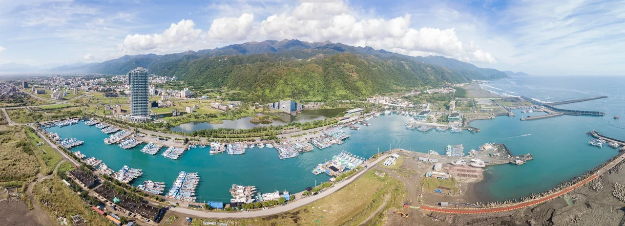

Toucheng
The Hsueshan Tunnel changed everything for Toucheng. Before it opened in 2006, the journey from Taipei to this corner of northeastern Taiwan meant a long drive over mountain passes — a journey that kept Yilan County in a kind of productive isolation, its dialects intact, its agriculture undisturbed. The tunnel collapsed that distance to about an hour, and the coast around Toucheng became suddenly accessible to Taipei's millions. But the township had been receiving travelers long before the tunnel, long before the road. The Kavalan people were here first, and they made Toucheng the gateway it has always been.
The Kavalan Gateway
Toucheng is one of the oldest settlements in Yilan County. The Kavalan, an Austronesian indigenous people, inhabited this stretch of northeastern coast for centuries before Han Chinese settlement during the Qing dynasty. The name Toucheng — 頭城, literally 'head city' — reflects its role as the first significant settlement travelers encountered when crossing into the Lanyang Plain from the northeast. During the Japanese colonial period, the town's regional importance grew further as new infrastructure connected Toucheng to the broader transportation network of the island. That layering of Kavalan, Qing, and Japanese histories has left traces that coexist without perfectly reconciling — a quality common to many Taiwanese towns, but especially pronounced in a place this old and this geographically distinct.
More Rail Stations Than Anywhere Else
Toucheng holds an unusual distinction: it has three railway stations, more than any other township in Taiwan. The stations serve the North Railway Line (北迴鐵路), which connects northeastern Taiwan to both Hualien in the south and Taipei in the north, threading through terrain where the mountains meet the Pacific coast. For travelers approaching from Taipei, Toucheng is the first stop after the line emerges from the hills onto the Yilan plain — a transition that announces itself in the sudden widening of sky and the smell of salt air. Guishan Island, a volcanic island roughly 10 kilometers offshore in the Philippine Sea, is visible on clear days from the coast. The island belongs administratively to Toucheng Township, making the township's geography as much ocean as land.
Surf and Sea at Honeymoon Bay
The coastline east of Toucheng offers something rare on Taiwan's west coast: consistent surf. Honeymoon Bay (蜜月灣), just south of the township center, breaks reliably enough to support a small surfing community. The northern side of Wushi Harbor (烏石漁港) also offers surf breaks, and the harbor itself is the departure point for whale and dolphin watching tours — advance booking is required, and the seasonal migrations of cetaceans through these waters make the tours genuinely worthwhile. The Philippine Sea is not a gentle body of water; the same swells that make it surfable also make Toucheng vulnerable to the typhoons that track northward along the coast every summer. Heavy rainfall is common from June through September, and the area's humidity rarely relents. Spring and autumn are when the coast reveals its most agreeable face.
Ghost Grappling and Deep Festival Time
Toucheng is perhaps best known outside Yilan County for its Ghost Month festival — the Toucheng Ghost Grappling Competition (搶孤), held annually on the last day of the lunar Ghost Month, in late summer or early autumn. Tall poles are erected and coated with grease. Teams of competitors attempt to climb them to reach offerings placed at the top, in a ritual that honors the hungry ghosts of those who died without family to tend their memory. The festival was banned for a period due to safety concerns, then revived. It draws crowds from across Taiwan and represents one of the most vivid expressions of the folk religious traditions that Tainan and other southern Taiwanese cities are also famous for — but in Toucheng, the competition's physical extremity gives it a particular intensity, a contest between human effort and the obligations owed to the dead.
From the Air
Toucheng sits at 24.85°N, 121.82°E where the northeastern coast of Taiwan meets the edge of the Yilan Plain. From altitude, the township's position at the northern end of the broad coastal lowland is clear — mountains crowd in from the west and north, while the blue of the Philippine Sea extends eastward. Guishan Island is visible as a distinctive volcanic cone roughly 10 km offshore. The nearest airport is RCYU (Yilan Airport), approximately 20 km to the south. Coastal winds can be strong, especially during the northeast monsoon season from October through March.
Nearby Stories
- Daxi Wude Hall 0.9 km away
- National Museum of Marine Science and Technology 1.8 km away
- Suao 3.6 km away
- Mount Dabajian 16 km away
- 2022 Chinese Military Exercises Around Taiwan 82 km away
- Sinking of MV Sewol 1068 km away
- Yellow Sea 1128 km away
- Sibuyan Island 1356 km away