.png)
Treaty Ports
On 11 July 1938, a Union Jack came down for the last time over Spike Island in Cork Harbour. Sixteen years after Ireland had become a Free State, the Royal Navy was finally handing back the last of its bases on Irish soil. Eamon de Valera and Frank Aiken were on the dock to take possession. In London, Winston Churchill stood in the House of Commons and called the handover a 'folly.' Within a year, Britain was at war and the Atlantic convoys had to swing 200 miles further north because the harbour at Cobh - which had been a Royal Navy refuelling base for a century - was now neutral. The Treaty Ports were three small dots on the map of Ireland that ended up changing the geography of the Second World War.
What the Treaty Took
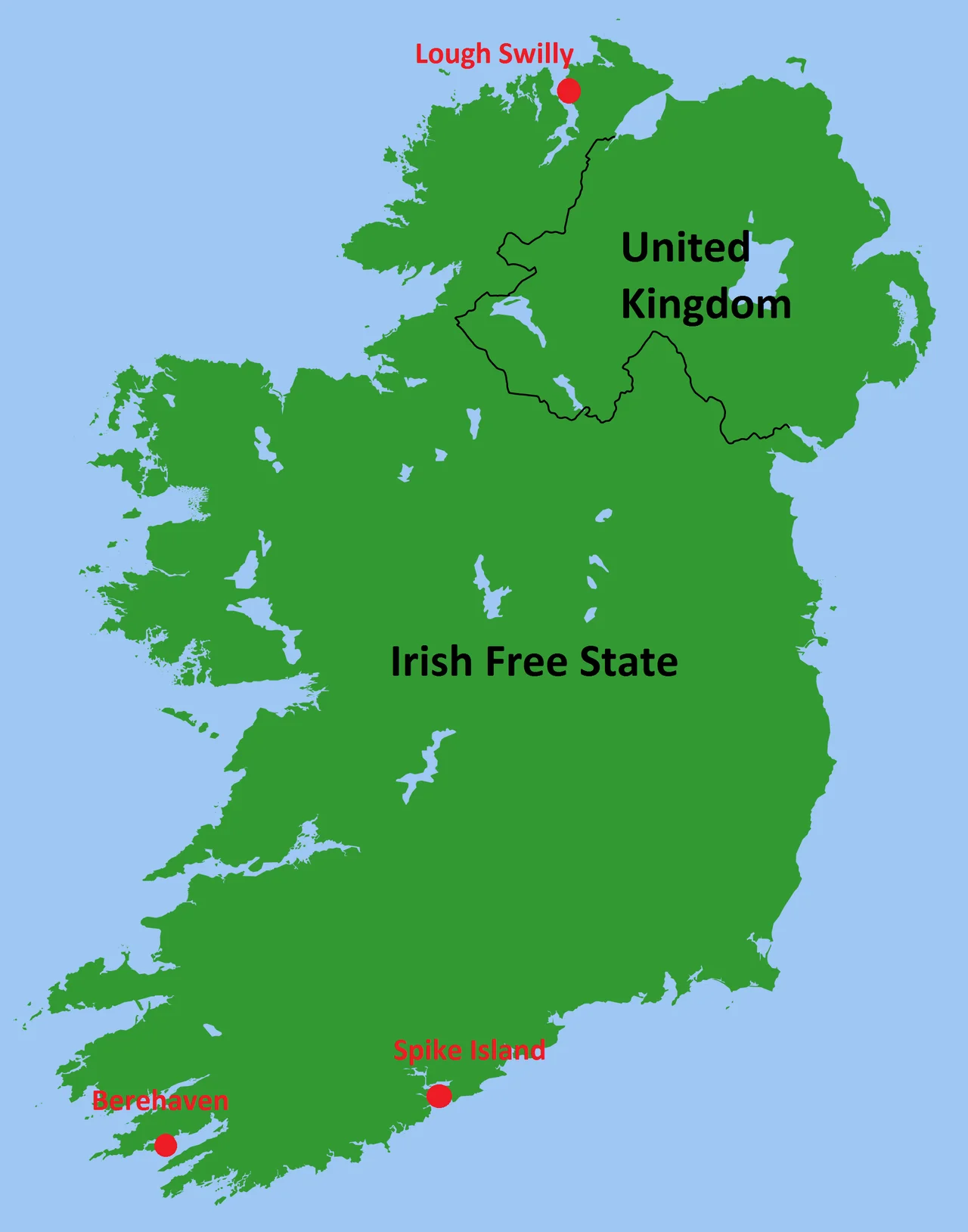
When the Anglo-Irish Treaty was signed on 6 December 1921, it gave the 26 counties their independence but left a few sharp things tucked into the small print. Article 7 reserved three deep-water harbours to the United Kingdom for naval use: Berehaven at Castletownbere on the southwest tip, Spike Island in Cork Harbour, and Lough Swilly in Donegal. The Annex actually listed a fourth - Belfast Lough - because the Treaty originally included all of Ireland, with the option for Northern Ireland to opt out. On 8 December 1922, Northern Ireland duly opted out, leaving the British with three exclaves in the Free State. The reason was simple: the U-boat campaign of the First World War had nearly strangled Britain, and the Royal Navy was not willing to surrender harbours that had been built specifically to defend the Western Approaches.
Sixteen Years of Awkwardness
From 1922 onward, the bases were increasingly uncomfortable for both sides. Irish foreign policy was moving toward neutrality - by the 1930s de Valera was a vocal champion of the League of Nations and a position outside great-power blocs. Royal Navy ships flying the Union Jack and refuelling at Berehaven and Spike contradicted that posture. From 1932 to 1938 the two countries fought the Anglo-Irish Trade War, a tariff dispute originating in de Valera's refusal to pay land annuities to Britain. In September 1937, Malcolm MacDonald told de Valera that London was willing to give up the ports - if Ireland would guarantee British use in wartime. De Valera was not willing to make that guarantee. He proposed talks anyway. The eventual agreement, signed in April 1938, did not include the wartime guarantee. The British, exhausted by the Trade War and not seriously expecting another European conflict for years, accepted.
Three Handovers, Three Months
The actual handovers came in quick succession that autumn. Spike Island was first, on 11 July 1938. The Times of London reported it with photographs of British families packing up and Irish dignitaries inspecting the fortress. On 29 September, Castletownbere and the batteries on Bere Island - Berehaven - were transferred; the Times wrongly proclaimed these the last British troops in Ireland. On 3 October, Fort Dunree at Lough Swilly in County Donegal was finally handed over. Within months the British forts were being renamed for Irish patriots: Fort Westmoreland on Spike became Fort Mitchel for the journalist John Mitchel, Fort Camden became Fort Meagher, Fort Carlisle became Fort Davis. The names on the gates changed; the casemates and gun pits and magazines did not.
Churchill's Folly
Almost nobody in Britain noticed at the time. Churchill was one of the few MPs who spoke against the handover. He told the Commons it was an 'astonishing triumph' for de Valera, and asked whether it would not be better to pay the £10 million Ireland was offering and keep a legal lease on the harbours. He was ridiculed for suggesting that Ireland might choose neutrality. When war came in September 1939, Ireland did exactly that. Without Berehaven and Cobh, Royal Navy escorts protecting convoys from North America had no fuelling stop on Ireland's south coast. Allied convoys were routed north through Iceland, adding hundreds of miles to each crossing. The Admiralty later estimated that the loss of the Treaty Ports led to the sinking of 368 Allied ships and the deaths of 5,070 sailors during the Battle of the Atlantic - a calculation made by men who had every reason to be bitter. Churchill, no longer ridiculed, would simply note: 'I told you so.'
What's Left to See
All three sites are open in some form today. Spike Island in Cork Harbour, the most accessible, became Europe's Leading Tourist Attraction in 2017 - boats run from Cobh and the star-shaped fortress, prison cells and gun emplacements can be walked through. Fort Davis at Whitegate and Camden Fort Meagher at Crosshaven, the companion installations defending the same harbour mouth, are owned by the Irish Defence Forces; Fort Meagher has been partially restored as a heritage site by Cork County Council. Berehaven's gun positions on Bere Island can be visited via the local ferry. Fort Dunree at Lough Swilly is now a military museum perched on the cliffs of the Inishowen peninsula. They are quiet places now. For sixteen years they were the last anomaly of an empire that had run out of reasons to stay.
From the Air
The three Treaty Ports stretch across Ireland's south and northwest coasts. Spike Island sits at 51.835 degrees N, 8.285 degrees W in Cork Harbour, near Cork Airport (EICK) - the most visible from the air, with its star-shaped fortress clearly readable from 5,000 feet. Berehaven (Castletownbere/Bere Island) lies at roughly 51.65 N, 9.90 W on the southwest tip of the Beara Peninsula, near Cork West (EICM) and Kerry Airport (EIKY). Lough Swilly at Fort Dunree sits at roughly 55.20 N, 7.55 W on the west side of the Inishowen Peninsula, with City of Derry Airport (EGAE) nearby. A complete Treaty Ports tour by air is essentially a tour of Ireland's strategic Atlantic harbours.
Nearby Stories
- Walter Siepmann 6.3 km away
- Gaeltacht na nDéise 11 km away
- Fermoy 12 km away
- Canovee 14 km away
- Rathcoole Ambush 16 km away
- SS Folia (1907) 20 km away
- Cloghan Castle, Lough Hyne 35 km away
- SM U-27 91 km away