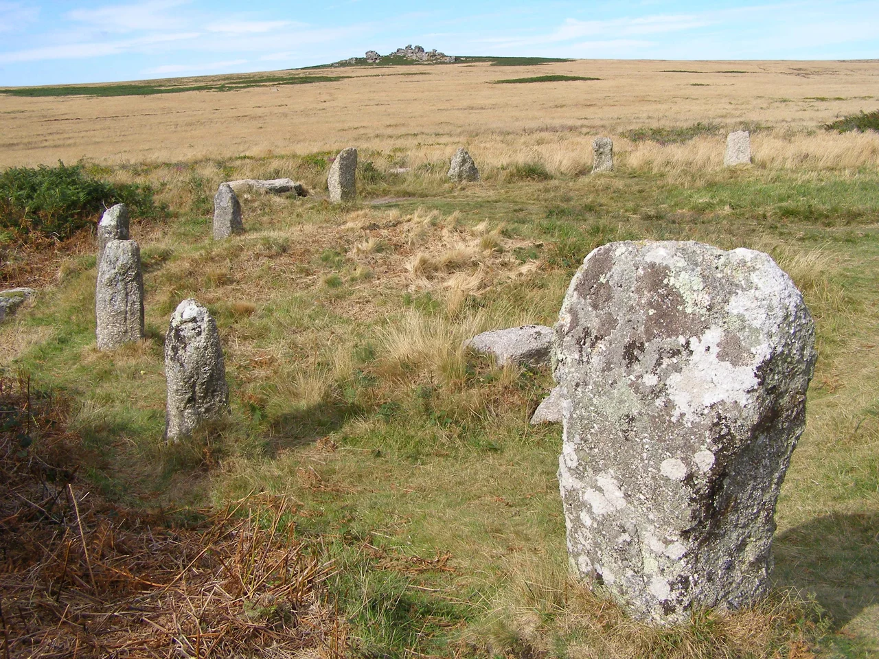

Tregeseal East Stone Circle
Dans Maen, the Cornish called them. Stones of the Dance. There are nineteen of them now, granite blocks waist-high or shoulder-high, set in a rough ring twenty-one metres across on the heather slopes below Carn Kenidjack. Once there were probably twenty-one stones in this circle and twenty-one stones in another two circles to the west, three rings strung along an east-west line across the hillside like three drumbeats. Two of those circles are essentially gone now, betrayed only by an aerial photograph from 1947 and a single lone stone in the middle position. Only the eastern circle still dances. It has been dancing here since roughly 2500 BC.
On the Hillside
The circle stands about one kilometre east of the hamlet of Tregeseal, in west Cornwall, on the high ground north of the road between Penzance and St Just in Penwith. Above it rises Carn Kenidjack, the carn whose dark granite tor crowns this stretch of moorland and casts a long afternoon shadow toward the stones. The land around the circle is heather and gorse, grazed by ponies and the occasional sheep, criss-crossed by walkers' paths and the older lines of long-vanished field boundaries. From the centre of the circle you can see south-west to the Atlantic and east toward the rolling country that climbs back toward Penzance. The position is not accidental. Bronze Age megalith-builders chose their sites very deliberately, and the line of three circles is part of a broader prehistoric arrangement still partly readable in the landscape - cairns, ritual enclosures, standing stones - that turns this whole hillside into a kind of open-air theatre.
Nineteen Stones, Heavily Restored
The 19 granite blocks that make up the surviving circle stand between roughly 1 and 1.5 metres tall, set in an approximate circle some 21 metres in diameter. Two stones are probably missing - older accounts describe 21. Like most surviving prehistoric monuments in Britain, the circle has been rebuilt and re-set several times across the centuries, and only the stones on the eastern half are thought to be in close to their original positions. Standing among them is still uncanny: each block is unworked, the granite weathered to grey with crusts of yellow lichen, the spacings irregular in a way that feels intentional rather than careless. Some stones lean slightly outward; others tip in. The diameter is wide enough to hold a small crowd but tight enough to feel deliberate.
A Line of Three
The Tregeseal East circle is the easternmost survivor of what was once a row of three circles aligned generally east-to-west, similar to the more famous arrangement around The Merry Maidens in west Penwith. The middle circle, recorded in 1885 as having the largest diameter and ten remaining stones, today has only a single standing stone left to mark its position. The third and westernmost circle, recorded only on RAF aerial photographs from 1947, is more uncertain; it is smaller, and may actually be the foundation of an Iron Age hut rather than another ceremonial ring. Whatever the precise number, the alignment is clear. Late Neolithic and early Bronze Age megalith-builders did not arrange circles in a row by accident. The line probably had astronomical significance - solar or lunar - and certainly had ritual significance. Walking the surviving stones, you walk through the broken remains of one of the more ambitious ceremonial landscapes in prehistoric Britain.
Antiquarians and Their Drawings
Tregeseal first enters the modern written record in 1754, in William Borlase's Antiquities, Historical and Monumental, of the County of Cornwall - the great Cornish antiquary's pioneering survey of the duchy's prehistoric monuments. Borlase, born at Pendeen Manor only a few miles away, counted 17 standing stones. In 1827 the antiquary William Cotton produced a careful drawing of the circle in his Illustrations of Stone Circles, Cromlehs and Other Remains of the Aboriginal Britons in the West of Cornwall - at which date some of the stones in the other two circles were still upright. A later William Borlase - William Copeland Borlase, descendant of the first - reported 15 stones in his 1872 Naenia Cornubia and mapped them precisely. Compare the three records and you can watch the monument lose stones across the 18th and 19th centuries, robbed for hedge-walls and gateposts. The restoration work began in earnest in the late 20th century, and the circle as it stands today is the outcome.
Dance of the Maidens
Across west Cornwall, prehistoric stone circles carry the same folk-name: the Merry Maidens, the Hurlers, the Nine Maidens of Boskednan, the Dancing Stones at Tregeseal. The story is variations on a theme. Young women - sometimes with their pipers, fiddlers, or husbands - were dancing or playing on the Sabbath. In their wickedness they were turned to stone, locked forever in the moment of their dance. The story is medieval and Christian, layered onto something far older that no one in the Middle Ages understood. The stones were inexplicable and faintly threatening; the legend made them safely cautionary. Stand inside the Tregeseal East circle in late afternoon, when Carn Kenidjack's shadow falls across the ring and the moor goes quiet, and the legend feels less foolish than it does in print. Whoever raised these stones four thousand years ago meant them to make their visitors feel exactly what visitors still feel: that they are inside a circle that has been here much longer than they have, and that will be here much longer too.
From the Air
Located at 50.1337°N, 5.6585°W, approximately 1 nm northeast of St Just in Penwith on the moors below Carn Kenidjack. The stone circle is small (21 m diameter) and best identified from low altitude by its position relative to Carn Kenidjack - a distinctive granite tor that rises sharply above the surrounding heather. The circle sits on the south-facing slope below the tor. Land's End Airport (EGHC) is 2 nm south-southwest. Recommended viewing altitude 1,000-2,000 ft. Best photographed in early morning or late afternoon when low sun raises the shadows of the individual stones; from directly overhead the circle is hard to pick out, but the broader prehistoric ritual landscape - cairns, field systems, standing stones - is easier to read at altitude than on the ground.
Nearby Stories
- Bartholomew Ledges Wreck 1.8 km away
- Carn Brea Castle 4.6 km away
- Battle off Lizard Point 12 km away
- Carnewas and Bedruthan Steps 18 km away
- King Charles's Castle 25 km away
- MV Cita 34 km away
- 1979 Fastnet Race 47 km away
- Trevose Head Lighthouse 55 km away