The Night the Wind Came for Santa Rosa
No cell phone alert sounded. At 9:43 p.m. on October 8, 2017, a fire ignited near Calistoga in Napa County. By midnight, driven by winds gusting to 70 miles per hour, it had crossed into Sonoma County. By 1:30 a.m., it was inside the city limits of Santa Rosa. Entire neighborhoods burned so fast that residents had minutes - not hours - to flee. The Tubbs Fire would destroy 5,643 structures, kill 22 people, and burn 36,807 acres before it was contained on October 31. It followed nearly the same path as the Hanly Fire of 1964, which had burned 52,700 acres of mostly open land. In the decades between, subdivisions, hospitals, and retirement communities had filled that corridor. History repeated itself, but this time there were neighborhoods in the way.
A Corridor with a Memory
Sonoma County has four historic wildfire corridors - paths that fire has followed repeatedly over the decades, shaped by terrain and prevailing winds. The Hanly Fire of 1964 traced one such path from Calistoga southwest through Mark West Springs and Wikiup to Mendocino Avenue, stopping across the street from Journey's End Mobile Home Park. That fire, the third largest in Sonoma County history, burned mostly open land. In the 53 years between the Hanly Fire and the Tubbs Fire, the Fountaingrove area filled with expensive homes, a golf course and clubhouse, medical buildings, retirement communities, and two hotels. The fire corridor remained; the fuel changed from grass and oak to structures and lives. New building codes required fire-resistant siding, roofing, and protected eaves. When the Tubbs Fire followed the Hanly corridor almost exactly, those requirements proved insufficient against winds approaching hurricane strength.
Minutes to Escape
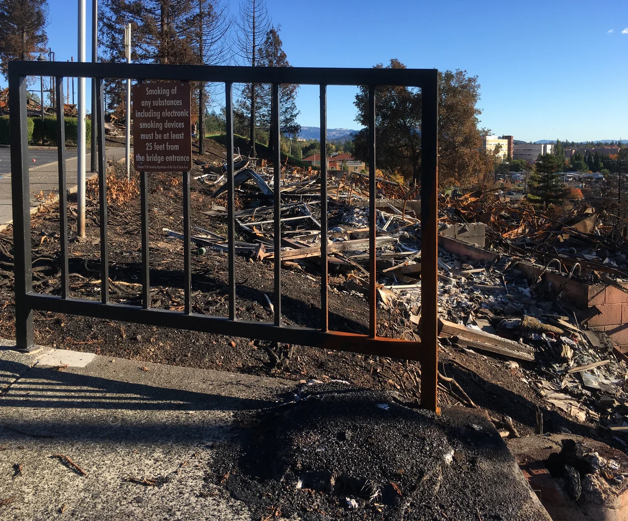
The speed of the fire shocked everyone, including firefighters. Propelled by Diablo winds - the hot, dry northeast winds that define Northern California's fire season - the Tubbs Fire covered the roughly 15 miles from Calistoga to Santa Rosa in a few hours. The Coffey Park subdivision in northwest Santa Rosa was virtually obliterated. More than 2,800 homes in the city alone were destroyed. Kaiser Permanente evacuated 130 patients from its Santa Rosa hospital. Safari West, a wildlife preserve in the fire's path, managed to save its animals - cheetahs, giraffes, rhinoceroses - through desperate effort by owner Peter Lang and his staff. One in six doctors in Santa Rosa lost their home. The Redwood Adventist Academy, the Fountaingrove Inn, Paradise Ridge Winery, and Willi's Wine Bar were among the landmarks reduced to ash.
Covering the Catastrophe
The Press Democrat, Santa Rosa's daily newspaper, covered the fire while its own staff members were losing their homes. Reporters worked from evacuation centers, filing stories between checking on their families. Their coverage - described by the Pulitzer committee as 'lucid and tenacious coverage of historic wildfires that ravaged the city of Santa Rosa and Sonoma County' - won the 2018 Pulitzer Prize for Breaking News Reporting. Social media became a lifeline during the crisis. Snapchat ran a geolocation filter that collected over 12,000 videos and images by October 11. Twitter became the primary platform for real-time updates, with the heaviest posting on October 11. Sonoma County's decision not to send a cell phone emergency alert became one of the fire's most debated controversies.
The Question of Blame
Suspicion fell immediately on Pacific Gas and Electric Company, the utility whose aging infrastructure had sparked fires before. Cal Fire's investigation, completed in January 2019, attributed the fire to private electrical equipment rather than PG&E lines, temporarily lifting the company's stock price. But private investigators disagreed, and victims pushed for a jury trial. The legal battle played out through PG&E's 2019 bankruptcy proceedings. U.S. Bankruptcy Judge Dennis Montali allowed a parallel civil trial to proceed, and PG&E's stock dropped 25 percent on the ruling. The trial was ultimately overtaken by a broader settlement: PG&E established a Fire Victim Trust in July 2020, funded with billions to compensate victims of the Tubbs Fire and other blazes. Sonoma County received nearly $150 million; the city of Santa Rosa received $95 million. Officials then faced a different kind of challenge - deciding how to spend it.
What Remains
The scars of the Tubbs Fire are both visible and invisible across Santa Rosa. Coffey Park has been largely rebuilt, though not entirely. The Fountaingrove neighborhood, perched on the hillsides where the fire burned hottest, has seen slower recovery. Journey's End Mobile Home Park, where the Hanly Fire stopped in 1964 but the Tubbs Fire did not, lost many of its residents - elderly people on fixed incomes who could not easily relocate. The fire prompted statewide conversations about building in wildfire zones, the maintenance of utility infrastructure, and the adequacy of emergency alert systems. California's wildfires have only intensified since 2017. The Tubbs Fire was the state's most destructive until the Camp Fire surpassed it just one year later, in November 2018. Each fire teaches the same lesson that the landscape has been teaching for centuries: the wind remembers the corridors, even when people forget.
From the Air
Located at 38.61°N, 122.20°W in the hills between Napa and Sonoma counties, northeast of Santa Rosa. From altitude, the fire's path is traceable from Calistoga southwest through Mark West Springs to the Fountaingrove area and Coffey Park in Santa Rosa. The terrain funnels northeast winds down through the valleys. The burned hillsides above Fountaingrove are visible from the air, as are the rebuilt subdivisions of Coffey Park. Nearest airports: Charles M. Schulz - Sonoma County Airport (KSTS) approximately 7 nm northwest; Napa County Airport (KAPC) approximately 15 nm east. Sonoma Mountain and the Mayacamas Range frame the fire corridor on both sides.
Nearby Stories
- Yolo Causeway 2.3 km away
- Eight Acres for a Plant That Exists Almost Nowhere 2.9 km away
- The Stone Chapel That Survived Everything 9 km away
- Where Carlin Took His Last Bow 11 km away
- Locke: The Town They Built But Could Not Own 14 km away
- Rico Harris 14 km away
- The Fence That Ran to the Sea 20 km away
- Sutter Hock Farm 22 km away