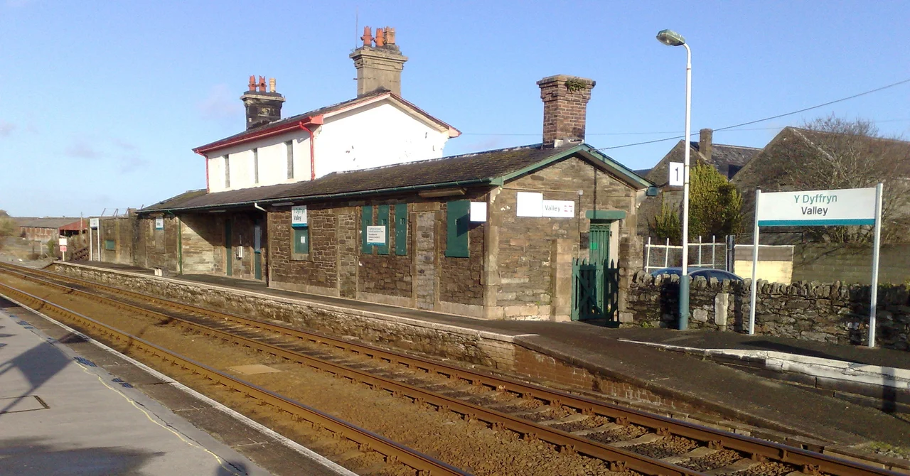

Valley, Anglesey
Stand in the middle of the village and you will hear it before you see it: the high crackle of a Hawk T2 trainer banking somewhere over the Irish Sea, or the deeper thunder of a Texan T1 turboprop on a circuit. RAF Valley is where the Royal Air Force teaches its fast-jet pilots how to be fast-jet pilots. The runways stretch across the flat west of Anglesey almost to the sea, and the village named Valley — Y Fali in Welsh — sits along their northern boundary, separated from the airfield by hedges, a few fields, and a road. The aviation has been here for a century. The name is older, though no one is sure how old, or quite where it came from.
Where the Name Comes From
The origin of 'Valley' has been argued for more than a hundred years. Thomas Morgan, writing in the 1880s, suggested it was a corruption of Mael-dy, 'house of trade', and linked the place to Tacitus's claim that the Romans traded with Ireland from somewhere on this coast in the time of Agricola. Gwilym T. Jones and Tomos Roberts, in their 1996 study of the place-names of Anglesey, offered two further possibilities: that the name comes from the Irish word baile (a settlement), brought across by sailors and traders; or that it was simply coined by the labourers who dug a long, deep trench through the flat land here in the 1820s, to yield rubble for the construction of Thomas Telford's Stanley Embankment carrying the A5 road across to Holyhead. The trench was, locally, a valley. The cluster of dwellings nearby took the workers' name. Early records call the area Glan Môr Tŷ Coch and Glan Môr Castell Llyfaint. In modern Welsh it is most often Y Fali — though for a time, until the early 2000s, the official Welsh form was Y Dyffryn, a literal translation of the English word.
RAF Valley
The airfield went in in 1941, originally as a Coastal Command base flying anti-submarine and air-sea-rescue missions over the western approaches and the Irish Sea. After the war it became a training station, and it has been one ever since. Generations of British pilots — and a long list of overseas officers training under various exchange schemes — have learned to fly fast jets here. The fast-jet school is currently equipped with BAE Hawk T2 trainers. The Search and Rescue helicopter flight that operated from the field for decades was where Prince William served as a flight lieutenant between 2010 and 2013. The runways are also used by Anglesey Airport (also known as Maes Awyr Môn), which runs commercial flights to Cardiff and previously served the Isle of Man. Across the road from the airfield, in the village, life carries on with the soundtrack of military jets the way Cornish villages live with the soundtrack of the surf.
Telford's Road and the Railway
Two great Victorian-era transport projects bisect the village. Thomas Telford's A5 road, completed in 1826, runs west-east on its way from London to Holyhead; the road was Telford's masterpiece, built to a uniform engineering standard with gentle gradients, drainage, and stone-faced embankments, and it changed Anglesey from a quiet backwater into the main link between London and Dublin (then the second city of the British Isles). The Stanley Embankment that carries the A5 across to Holy Island is the engineering achievement that arguably gave the village its name. Half a century later, in 1850, Robert Stephenson's Britannia Bridge brought the Chester and Holyhead Railway across the Menai Strait, and the line was extended westward through Valley to its terminus at Holyhead. Valley railway station, still in service, sits on the North Wales Coast Line; its Victorian signal box is Grade II listed.
The People
The community of Valley includes the village of Llanynghenedl and part of Four Mile Bridge, with a 2011 population of 2,361 — slightly down from 2,413 a decade earlier. The football club CPD Y Fali plays in Division One of the North Wales Coast West Football League, on a ground squeezed between the railway line and the A55 expressway. Two names from Valley are widely known beyond the village. Gareth Williams (1978–2010), a Welsh mathematician who worked for GCHQ and was seconded to MI6, was found dead in suspicious circumstances in London in August 2010 — the so-called 'spy in the bag' case, never solved, that briefly made headlines around the world. He is buried in Ynys Wen Cemetery here. The other name is George North, the Wales and Ospreys rugby international, who attended Ysgol Gymuned Y Fali, the village school. A small Anglesey village has produced an unsolved intelligence mystery, a national rugby star, and a long line of fast-jet pilots, which is not a bad record.
The Land Around
Valley sits in the flat coastal plain of western Anglesey. To the south, the salt marshes of the Cefni estuary; to the west, the bridge across to Holy Island; to the north, gentle farmland leading up to the cliffs around Carmel Head; to the east, the long horizon of the Snowdonian mountains across the Menai Strait, which on a clear day are an astonishing presence on the skyline. The airfield, the village, and Llyn Penrhyn (a small natural lake just east of the runways) make a recognisable cluster from the air. The Skerries lighthouse and the Stack lighthouse are both visible in good weather from the higher ground above the village. The land is, as the Welsh phrase has it, llydan a llonydd — wide and quiet, except when the Hawks are flying.
Flight Context
Valley sits at 53.284°N, 4.562°W, immediately adjacent to RAF Valley (ICAO EGOV) on the west coast of Anglesey. The village itself is north of the airfield; the runways stretch southwest toward the Stanley Embankment. The single most important piece of airspace knowledge for any aviator near this place: RAF Valley's MATZ (Military Aerodrome Traffic Zone) extends to 3,000 ft above airfield elevation and is busy with fast-jet training traffic at almost all daylight hours on weekdays. Civilian general aviation traffic uses Anglesey Airport on the same runways under tower control. Visible landmarks from altitude include the Britannia Bridge and Menai Suspension Bridge to the east, Holyhead Mountain to the west, and the Snowdonian mountains across the Menai Strait.
From the Air
Coordinates 53.284°N, 4.562°W (Valley village, immediately north of RAF Valley airfield, west coast of Anglesey). Recommended viewing altitude 2,000–4,000 ft AGL — but check NOTAMs and the RAF Valley MATZ, which is active during fast-jet training. Nearest airport RAF Valley (EGOV) itself; civilian operations as Anglesey Airport on the same runways. Visible landmarks: the airfield, the Stanley Embankment carrying the A5 west to Holy Island, the Snowdonian mountains across the Menai Strait.
Nearby Stories
- Llandudno Lifeboat Station 3.8 km away
- Glynllifon 6.1 km away
- German submarine U-1024 9.4 km away
- Irish Sea Bridge 11 km away
- Ysbyty Ifan 12 km away
- Irish Sea 18 km away
- Celtic Array 18 km away
- Birkdale Palace Hotel 56 km away